This item has been sold, but you can get on the Waitlist to be notified if another example becomes available, or purchase a digital scan.
1944 Rand McNally Pictorial Map of Military Bases Across the United States
MilitaryPosts-randmcnally-1944$175.00

Title
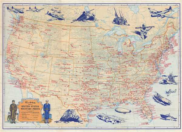
Rand McNally Map of United States Military Posts.
1944 (dated) 18.25 x 26 in (46.355 x 66.04 cm) 1 : 7300000
1944 (dated) 18.25 x 26 in (46.355 x 66.04 cm) 1 : 7300000
Description
This is a 1944 Rand McNally map of the United States which labels all the military installations from California to New York. The map depicts the United States from the Pacific Ocean to the Atlantic Ocean and from Canada to Mexico. The map differentiates between the different types of military posts by using different symbols. Airfields, bases, and stations are illustrated by small airplanes, while naval bases are indicated using an anchor inside a circle. Army camps, forts, and posts are labeled by a square with a dot at the center. Airfields and army installations are present in all 48 states, while naval bases are only located along the East, West, and Gulf coasts. On a more basic level, myriad cities and towns are labeled throughout and the rail network is illustrated and labeled from coast to coast. Several national parks are illustrated and labeled, including Yellowstone National Park and Grand Canyon National Park. The whole is surrounded by a series of military-inspired vignettes, including fighter aircraft, a Sherman tank, an anti-aircraft gun, a soldier with a bazooka, and B-17 Flying Fortress (one of the most celebrated aircraft of the war) along the top border. In the lower right corner, illustrations of a battleship, an aircraft carrier, and a PT boat (like the one commanded by President John F. Kennedy). A decorative title cartouche, including the legend, is situated in the lower left corner, and is flanked by a navy enlisted man and an army enlisted man.
This map was created and published by Rand McNally and Company of Chicago in 1944.
This map was created and published by Rand McNally and Company of Chicago in 1944.
Cartographer
Rand, McNally and Co. (fl. 1856 - present) is an American publisher of maps, atlases and globes. The company was founded in 1856 when William H. Rand, a native of Quincy, Massachusetts, opened a print shop in Chicago. Rand hired the recent Irish immigrant Andrew McNally to assist in the shop giving him a wage of 9 USD per week. The duo landed several important contracts, including the Tribune's (later renamed the Chicago Tribune) printing operation. In 1872, Rand McNally produced its first map, a railroad guide, using a new cost effective printing technique known as wax process engraving. As Chicago developed as a railway hub, the Rand firm, now incorporated as Rand McNally, began producing a wide array of railroad maps and guides. Over time, the firm expanded into atlases, globes, educational material, and general literature. By embracing the wax engraving process, Rand McNally was able to dominate the map and atlas market, pushing more traditional American lithographic publishers like Colton, Johnson, and Mitchell out of business. Eventually Rand McNally opened an annex office in New York City headed by Caleb S. Hammond, whose name is today synonymous with maps and atlases, and who later started his own map company, C. S. Hammond & Co. Both firms remain in business. More by this mapmaker...
Condition
Very good. Light wear along original fold lines. Verso repaiors to margin fold separations. Text on verso.
References
Rumsey 6783.003. OCLC 953572862.