This item has been sold, but you can get on the Waitlist to be notified if another example becomes available, or purchase a digital scan.
1889 Coates and Worden Map of Milwaukee, Wisconsin
Milwaukee-coatesworden-1889$175.00

Title
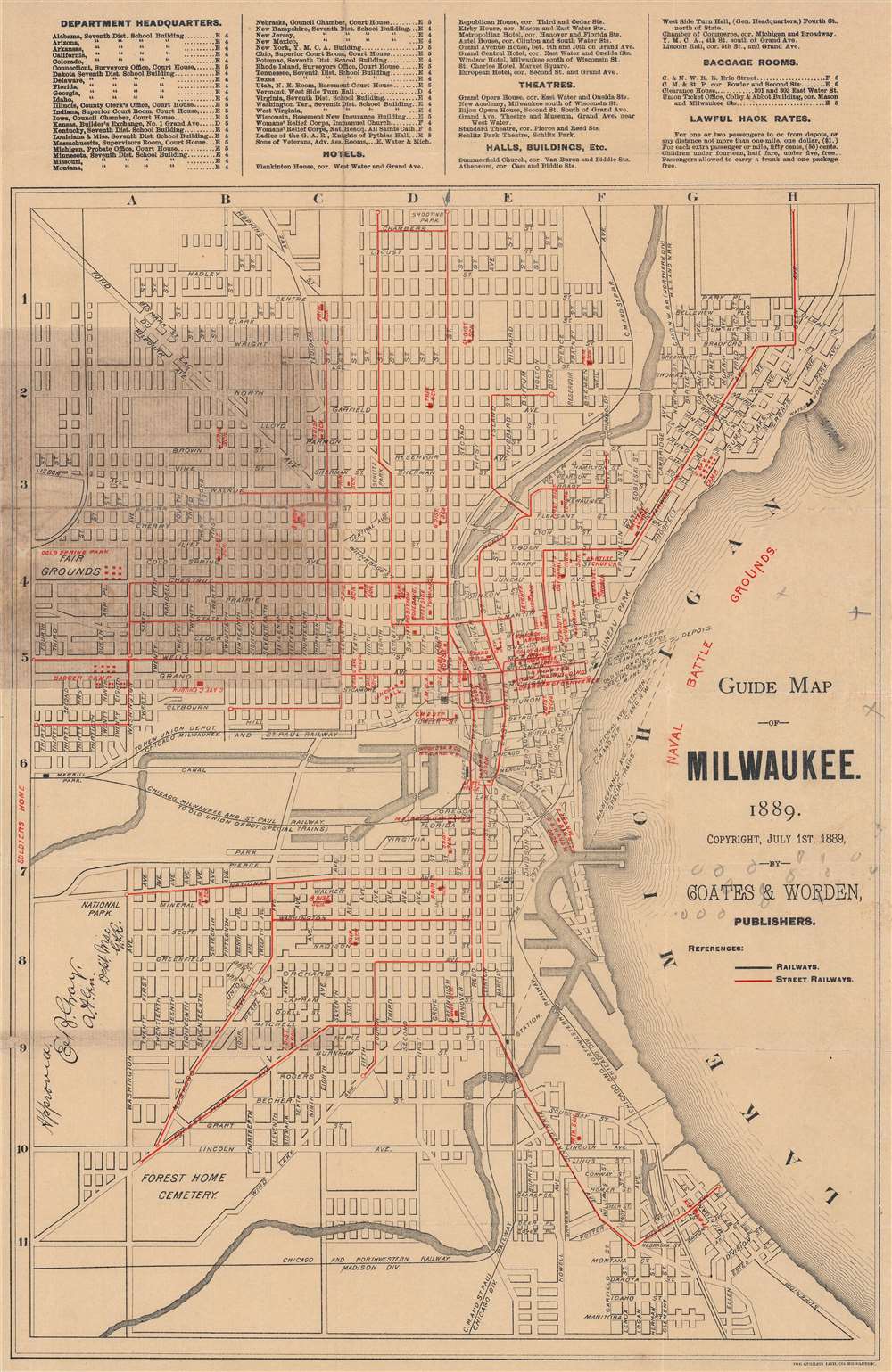
Guide Map of Milwaukee.
1889 (dated) 16 x 12 in (40.64 x 30.48 cm) 1 : 22500
1889 (dated) 16 x 12 in (40.64 x 30.48 cm) 1 : 22500
Description
A rare 1889 map of Milwaukee published by Coates and Worden. It displays the city during a period of breakneck population growth, when it developed into one of the main industrial and economic centers of the Upper Midwest.
This map was produced during a period when the city's population was booming, the result of an increasingly industrialized economy (aided greatly by the railroads) and immigration, especially from Germany. The city's population more than doubled between 1870 and 1890, in part the result of the incorporation of growing suburbs on the city's edge, such as Bay View at bottom-right. The city's growing prominence was reflected in a set of grand new structures built in the years after this map's publication, including a new City Hall and the Pabst Building.
This rapid expansion led to social and racial tensions. In large measure due to the political leanings of the city's German immigrants, a robust labor and Socialist movement caused consternation for the city's elite, with strikes and other forms of unrest a regular concern. Meanwhile, the same year that this map was published anti-Chinese riots resulting from anxieties over interracial sexual relations roiled the city.
A Closer Look
Coverage ranges from today's Burleigh St. in the north to Oklahoma Ave. in the south, and from Lake Michigan in the east to 35th St. in the west. Important public buildings, including government buildings, train stations, churches, schools, parks, and a 'badger camp' (most likely an organization of Union veterans of the U.S. Civil War), are indicated with red text. Red lines denote streetcar lines while black lines are used for railroads. Railroad depots are listed over the waters of Lake Michigan with dashed lines pointing to their respective locations. Handwriting, most likely the original owner's name, appears at left towards bottom, and a number of penciled annotations appear throughout.This map was produced during a period when the city's population was booming, the result of an increasingly industrialized economy (aided greatly by the railroads) and immigration, especially from Germany. The city's population more than doubled between 1870 and 1890, in part the result of the incorporation of growing suburbs on the city's edge, such as Bay View at bottom-right. The city's growing prominence was reflected in a set of grand new structures built in the years after this map's publication, including a new City Hall and the Pabst Building.
This rapid expansion led to social and racial tensions. In large measure due to the political leanings of the city's German immigrants, a robust labor and Socialist movement caused consternation for the city's elite, with strikes and other forms of unrest a regular concern. Meanwhile, the same year that this map was published anti-Chinese riots resulting from anxieties over interracial sexual relations roiled the city.
Publication History and Census
This map was lithographed by the Gugler Lithograph Co. and published by Coates and Worden in Milwaukee in 1889. Little is known about either company, and we have been unable to locate any other examples of this map, either in institutional collections or on the market.Condition
Good. Wear, discoloration, and chipping along fold lines. 'Pinhole' areas of loss at some fold intersections. Area of discoloration at left.