
1875 Schmidt / Kuhlmann Wall Map of Milwaukee, Wisconsin


Map of the City of Milwaukee...
Milwaukee: German Athens of America.
- Digital Map Information
- Suitable for large format printing
- Full resolution TIFF file
- ICC color profile embedded
- Delivered instantly via download link
Milwaukee: German Athens of America.
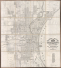
This is William Schmidt and H. V. Kuhlmann's large-format c. 1875 wall map of Milwaukee, Wisconsin. It is the finest map of Milwaukee during the late 19th century, when it underwent a period of fast-paced immigration-fueled development. The map is invaluable as a snapshot of Milwaukee’s emergence as an industrial and immigrant metropolis, documenting neighborhoods, infrastructure, and development patterns.A Closer Look
This map covers Milwaukee and its immediate environs, from the vicinity of today's Locust Street in the north to Lincoln Avenue in the south, and west just past Twenty Second Avenue (now 22nd Street). In the developed parts of the city, subdivisions, blocks, and lots are labeled. Along the edge of the city and in its hinterland, property owners are recorded, as are new developments (additions). Schools, hospitals, parks, reservoirs, and a race course at left are marked, while a list of fire alarm stations appears below the title at right.Streets, waterways, railroads, and the city's horsecar network (light dashed lines) are indicated throughout. A bolder set of dashed lines likely refers to horsecar lines actively under construction, as the line at left along 22nd Street represents the West Side Street Railway Company, established in 1874 and built over the following years. Handwritten annotations appear to trace planned expansions of the horsecar network. The railroads noted include the Chicago and North Western Railway, the Wisconsin Union Railway, the Milwaukee and St. Paul (better known as the Milwaukee Road), the Milwaukee and Prairie du Chien Railway (a subsidiary of the Milwaukee Road), and the Milwaukee and Northern Railway (traced but not labeled).
Overall, the map presents a city undergoing transformation, as evidenced by older structures that do not neatly align with the city grid, such as the Orphan Asylums (established 1848 and 1850, respectively) and St. Mary's Hospital (in this location since 1858) towards the top-right. Similarly, in the same area, the street grid is interrupted by larger, rural lots not yet sold, but it is laid out with the expectation that those lots will soon be sold to make way for urban development. Faint handwritten annotations appear throughout the upper-right, likely referring to land sales. Elsewhere, minor waterways flow through neighborhoods, suggesting they were built over or that the neighborhood was planned but did not yet exist.
Historical Context
This map was produced at a time when Milwaukee was growing at a tremendous pace. Between the 1850s and the 1870s, the city's population skyrocketed, expanding from roughly 20,000 residents to over 100,000. This explosive growth was fueled primarily by a massive wave of European immigration, predominantly from Germany in the wake of the Revolutions of 1848. By 1860, over half of Milwaukee's population was foreign-born, earning the city the nickname the 'German Athens of America' due to its rich array of German-language newspapers, theaters, and musical societies. Alongside substantial Irish neighborhoods and the initial arrival of Polish immigrants in the 1870s, these communities established the distinct cultural, political, and architectural identity of the city.Economically, the city evolved from a trading post on the shores of Lake Michigan into a formidable industrial powerhouse. Capitalizing on its excellent natural harbor and an expanding railroad network, the city emerged as a commercial giant, briefly becoming the world's largest wheat exporter during the early 1860s. As the 1870s progressed, the local economy shifted from simply shipping raw grain to processing agricultural goods. Heavy iron foundries, leather tanneries, and meat-packing plants flourished, while pioneering commercial operations like Pabst, Schlitz, and Miller cemented Milwaukee's legacy as America's premier 'Brew City.'
Publication History and Census
This map was prepared by draughtsmen William Schmidt and H. V. Kuhlmann and published by Schmidt and Christian H. Meyer, all employees of the city's Board of Public Works, with at least the former two working for the City Engineer's Office therein. The map is undated, but from features present, it is thought to be c. 1875. However, the incomplete state of the West Side Street Railway Company and the name of the Milwaukee and St. Paul Railway (as opposed to the Chicago, Milwaukee and St. Paul Railway) suggest that it may have been published in 1874, or at least based on surveys from that date.The OCLC listing for this map combines original examples and reproductions. A search of the relevant catalogs locates originals only at the Milwaukee Public Library, Wisconsin Historical Society, the Bibliothèque et Archives nationales du Québec, and the Bibliothèque nationale de France.
Cartographers
William J. Schmidt (April 13, 1840 - May 15, 1909) was a draughtsman in the City Engineer's Department of Milwaukee. Like many in Milwaukee, he was born in Germany, in Lower Saxony, and emigrated in the aftermath of the Revolutions of 1848, arriving in the U.S. in 1849. His family originally settled in Baltimore but early in his adult life, Schmidt travelled to Milwaukee for work and decided to relocate there. By June 1870, Schmidt was working for the City of Milwaukee as a civil engineer and draughtsman, where he would spend nearly 40 years. By the end of his career, he had risen to the position of 'Chief Draughtsman,' soon thereafter renamed 'City Draughtsman,' and was described upon his death in 1909 as 'in point of service the oldest employee of the city.' Schmidt was known to be a knowledgeable and assiduous public servant, hardly missing a day of work in his decades with the city and only stopping work a week before his death despite suffering from throat cancer. His son, also named William Schmidt, worked in the city's Water Department for many years. Further Details...
H. V. Kuhlmann (fl. c. 1873 - 1875) was a 'chainman' in the Milwaukee City Engineer's office in 1873. He may have been later involved with public schools in the city, being a member of the Board of Public Schools and a School Commissioner for the 15th Ward, though it is unclear if this is the same individual. The City Engineer's Department also employed one Edward J. Kuhlmann, perhaps a relative, as a clerk and draughtsman for many years in the late 19th and early 20th centuries, while one William Kuhlman is listed in city directories of the late 1880s as a draughtsman. Further Details...
Christian Hinrich Meyer (March 1843 - July 21, 1910) was a well-known 'pioneer' of Milwaukee, Wisconsin and a long-time government employee. Born in Schleswig-Holstein, Germany, Meyer emigrated to Milwaukee in 1846, as a child of 3. At the time, Milwaukee was still an assemblage of three competing towns - Milwaukee, Juneautown, and Kilbourntown - Meyer was a Milwaukee lifer. After completing school, he worked as a clerk for the county and city in multiple offices, including the Milwaukee Board of Public Works and Board of Supervisors, leading to his signature being ubiquitous on city records of the time. He later, c. 1881, went into the private sector, acting as an executor of estates and working for a lumber company, before heading the real estate and tax department of the Joseph Schlitz Brewing Co. for some twenty years. Further Details...
Milwaukee Lithographing and Engraving Company (c. 1872 - 1920) was a printing company based in its namesake city that is often considered to be the first modern printer in Milwaukee. The firm was founded by the German-born Henry Seifert (1824 - 1911), who had worked as a lithographer and printer for several years before immigrating to Milwaukee in 1852 and founding his own firm, 'H. Seifert, Lith.,' which produced bank notes, stationary, advertising cards, and the like. Seifert entered into several partnerships in the following years, the first being in 1856 with the Austrian-born artist Louis Kurz (1834 - 1921), who went on to become a partner in one of the major lithographic publishers of the late 19th century, Chicago-based Kurz and Allison. The Seifert-Kurz partnership was short lived and might have overlapped with Seifert's partnership with engraver James Lawton. In 1872, Lawton left to join the Western Bank Note and Engraving Co. in Chicago. From 1869, Seifert employed a talented young German-born engraver and printer named Julius Gugler. In 1871, Julius was joined by his father Henry, who had already had a long career in the field, and in 1872, Seifert and the Guglers founded the Milwaukee Lithographing and Engraving Company. They also look to have established a separate firm in 1875 called Seifert, Gugler, and Co. aiming to print public documents for the City of Milwaukee and State of Wisconsin, but this firm stopped operating after 1878. In 1876, the Milwaukee Lithographing and Engraving Co. constructed a three-story plant in downtown Milwaukee; by this time, they operated three state-of-the-art steam presses alongside sixteen hand presses. In 1878, the Guglers left to found their own firm, first as Henry Gugler and Sons and then the Gugler Lithographic Co. after Henry's death in 1880. The Gugler Lithographic Co. went on to great successes and only closed in 2005. As for the Milwaukee Lithographing and Engraving Co., it was noted in documents of the late 19th century as part of the Seifert Press, suggesting a subsidiary status. Fred Brosius (1851 - 1909), twin brother of viewmaker Herman Brosius (1851 - 1917), became president of the Milwaukee Lithographing and Engraving Co. when Seifert retired in 1898 and the company continued to operate until the late 1910s. Some obituaries of Henry Seifert credited him with operating 'the first lithographing plant in the West.' Further Details...
Condition
Very good. Full professional restoration. Dissected and mounted on linen. Some areas of infill. Wear along original fold lines. Some handwritten annotations.
References
OCLC 760205147.