
1595 Mercator Map of Africa (First Atlas Issue)

This item has been sold.
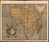
Africa Ex magnus orbis terre descriptione Gerardi Mercatoris desumpta. Studio and industria G.M. Iunioris.
Influential mapping of Africa, in its first state, by 'The Ptolemy of His Age'.
- Digital Map Information
- Suitable for large format printing
- Full resolution TIFF file
- ICC color profile embedded
- Delivered instantly via download link
Influential mapping of Africa, in its first state, by 'The Ptolemy of His Age'.
This is the 1595 first edition of Gerard Mercator's map of Africa - a classic, early Dutch depiction of the continent derived from Gerard Mercator's 1569 wall map of the world. It was engraved by the illustrious Gerard's grandson, Gerard the Younger, whose command of the engravers' craft is brilliantly apparent.Same Sources - Different Results
The elder Mercator incorporated several modern sources in compiling the Africa data for his 1569 world map. These included Waldseemüller's 1513 maps of northwest and south Africa. For much of his general outline, he relied on the 1564 Gastaldi wall map of Africa. Since Gastaldi's map and the reports of Leo Africanus informed Ortelius as well, it is remarkable the extent to which Mercator's map resembles neither those of Ortelius nor Gastaldi. Mercator's map includes very different river systems. For example, the R. de Infante (Great Fish River, South Africa), whose length is exaggerated in all maps of this era, appears to run directly north on the Gastaldi, extending well above the tropic of Capricorn. Mercator's map reduces the length of the river and presents its angular course more accurately. Also, Mercator's depiction of the Abyssinian river systems differs significantly from that of Ortelius/Gastaldi, as does his naming of kingdoms in the region - all suggesting a familiarity with contemporaneous Portuguese sources beyond those available to Gastaldi.Prester John
In the mid-16th century, the Portuguese were the most active Europeans in East Africa. In part, their goal was to contact and open relations with the Coptic Christian Abyssinian kingdoms of the Upper Nile. European travelers and geographers believed this, and not Asia, was the location of the fabled kingdom of Prester John. Accordingly, Mercator's map presents the enthroned, crucifix-displaying ruler just west of the Nile, between the kingdoms of Nubia, Barnagas, and Tigre.Publication History and Census
Gerard Mercator the Younger engraved this map, and it was included in the first, posthumous 1595 edition of Mercator's Atlas Sive Cosmographicae Meditationes De Fabrica Mundi et Fabricati Figura. It remained in the atlases after Hondius purchased the plates until 1633, staying in publication concurrently with Hondius' own Nova Africae Tabula. In its various editions, the map is well represented in institutional collections and appears occasionally on the market. This specific example conforms typographically to the first, 1595 printing of the atlas. We see 6 examples of this 1595 Duisberg edition of the separate map in institutional collections, and about 30 examples of the 1595 atlas in OCLC.Cartographer
Gerard Mercator (March 5, 1512 - December 2, 1594) is a seminal figure in the history of cartography. Mercator was born near Antwerp as Gerard de Cremere in Rupelmonde. He studied Latin, mathematics, and religion in Rupelmonde before his Uncle, Gisbert, a priest, arranged for him to be sent to Hertogenbosch to study under the Brothers of the Common Life. There he was taught by the celebrated Dutch humanist Georgius Macropedius (Joris van Lanckvelt; April 1487 - July 1558). It was there that he changed him name, adapting the Latin term for 'Merchant', that is 'Mercator'. He went on to study at the University of Louvain. After some time, he left Louvain to travel extensively, but returned in 1534 to study mathematics under Gemma Frisius (1508 - 1555). He produced his first world map in 1538 - notable as being the first to represent North America stretching from the Arctic to the southern polar regions. This impressive work earned him the patronage of the Emperor Charles V, for whom along with Van der Heyden and Gemma Frisius, he constructed a terrestrial globe. He then produced an important 1541 globe - the first to offer rhumb lines. Despite growing fame and imperial patronage, Mercator was accused of heresy and in 1552. His accusations were partially due to his Protestant faith, and partly due to his travels, which aroused suspicion. After being released from prison with the support of the University of Louvain, he resumed his cartographic work. It was during this period that he became a close fried to English polymath John Dee (1527 - 1609), who arrived in Louvain in 1548, and with whom Mercator maintained a lifelong correspondence. In 1552, Mercator set himself up as a cartographer in Duisburg and began work on his revised edition of Ptolemy's Geographia. He also taught mathematics in Duisburg from 1559 to 1562. In 1564, he became the Court Cosmographer to Duke Wilhelm of Cleve. During this period, he began to perfect the novel projection for which he is best remembered. The 'Mercator Projection' was first used in 1569 for a massive world map on 18 sheets. On May 5, 1590 Mercator had a stroke which left him paralyzed on his left side. He slowly recovered but suffered frustration at his inability to continue making maps. By 1592, he recovered enough that he was able to work again but by that time he was losing his vision. He had a second stroke near the end of 1593, after which he briefly lost speech. He recovered some power of speech before a third stroke marked his end. Following Mercator's death his descendants, particularly his youngest son Rumold (1541 - December 31, 1599) completed many of his maps and in 1595, published his Atlas. Nonetheless, lacking their father's drive and genius, the firm but languished under heavy competition from Abraham Ortelius. It was not until Mercator's plates were purchased and republished (Mercator / Hondius) by Henricus Hondius II (1597 - 1651) and Jan Jansson (1588 - 1664) that his position as the preeminent cartographer of the age was re-established. Further Details...
Source
Mercator, G., Atlas Editio Quarta, (Duisberg) 1595.
Condition
Very good. Offset stains resulting from oxidation of the original green. Centerfold reinforced near bottom. Generous margins and original color.
References
OCLC 633410478. Betz 31; Norwich 21. van der Krogt 8600 : 1A.