1931 Milwaukee Electric Railway and Light Co. City Plan or Map of Milwaukee, WI
MilwaukeeStreetRailway-tmerl-1931$350.00


Title
Street Railway and Motor Bus Guide of Milwaukee. 'Ride the Street Car or Motor Bus'.
1931 (dated) 20.5 x 17.75 in (52.07 x 45.085 cm)
1931 (dated) 20.5 x 17.75 in (52.07 x 45.085 cm)
Description
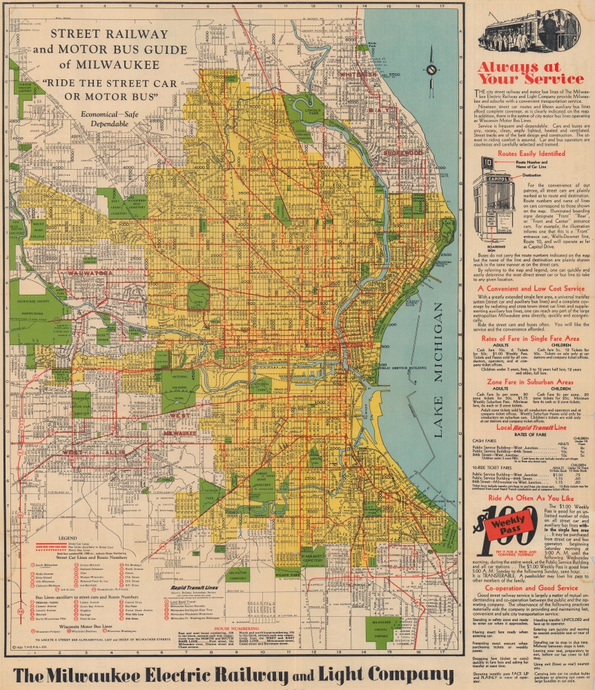
This is a 1931 Milwaukee Electric Railway and Light Company city plan or map of Milwaukee, Wisconsin. It captures the breakneck growth of Milwaukee's public transportation system in the first decades of the 20th century.
A Closer Look
Coverage embraces Milwaukee from Mill Road south to the Milwaukee County Airport and from the New Blue Mound Country Club to Lake Michigan. Red overprinting highlights the city's streetcar, bus, and interurban rail lines. Each line is numerically identified to correspond with a key in the lower left. Streets are illustrated throughout, along with canals, parks, golf courses, and cemeteries. The Public Service Building, the Milwaukee Electric Railway and Light Company's corporate headquarters, are marked by a large red dot and arrow. This building opened in 1905 and served as the Milwaukee Railway and Light Company's interurban terminal. Ten lines operated inside the building and another three boarded outside. Not far away, the rail lines of the Chicago, Milwaukee, St. Paul and Pacific Railroad are also identified.The Milwaukee Electric Railway and Light Company
The Milwaukee Electric Railway and Light Company (1896 - 1938) (TM) was an electric street railway and electricity provider in Milwaukee, Wisconsin, and the surrounding region. Founded in January 1896, TM emerged from the bankruptcy of the Milwaukee Street Railway, which began operation in 1890, and had consolidated most of Milwaukee's horse-drawn streetcars. Milwaukee's streetcar and interurban railroad network grew exponentially in the early part of the 20th century, eventually operating 180 miles of track within the city limits alone. By the time of this map's publication, TM operated 19 streetcar lines and 15 bus lines in Milwaukee and interurban rail lines to Racine, Kenosha, Burlington, East Troy, Waukesha, Watertown, Port Washington, and Sheboygan. Ridership had fallen off by the early 1930s due to the popularity of private cars and continued to fall throughout the Great Depression. Ridership slightly rebounded during World War II (1939 - 1945) due to gasoline and tire rationing. Defense workers commuting to work also helped increase ridership. However, after the war, ridership decreased rapidly, and all of Milwaukee's streetcar lines were abandoned by 1958.Publication History and Census
This map was published by the Milwaukee Electric Railway and Light Company in 1931. We note eight examples cataloged in OCLC: University of Michigan, the Indiana Historical Society Library, the University of Chicago, the University of Illinois at Urbana Champaign, the Wisconsin Historical Society, the University of Minnesota Twin Cities, and Stanford University.Condition
Good. Wear and toning along original fold lines. Small areas of loss along fold lines and at fold intersections. Text on verso. Light dampstaining. Slight loss to one margin not effecting printed area on either side.
References
OCLC 225177138.