This item has been sold, but you can get on the Waitlist to be notified if another example becomes available, or purchase a digital scan.
1899 Rice City Map or Plan of Minneapolis, Minnesota
Minneapolis-rice-1899$600.00

Title
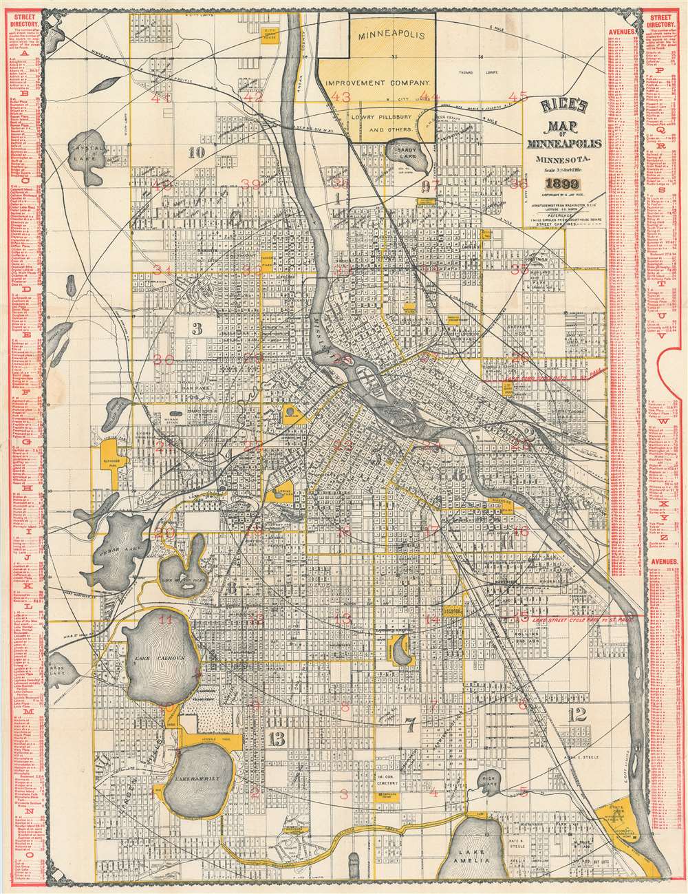
Rice's Map of Minneapolis Minnesota.
1899 (dated) 33.25 x 25.5 in (84.455 x 64.77 cm) 1 : 19495
1899 (dated) 33.25 x 25.5 in (84.455 x 64.77 cm) 1 : 19495
Description
This is an 1899 G. Jay Rice city map or plan of Minneapolis, Minnesota. The map depicts the region from Sweeney Lake and Bass Lake to the eastern city limits of Minneapolis and from the northern city limits of Minneapolis to Lake Amelia and the southern city limits. Highly detailed, myriad streets are illustrated and labeled throughout the city. Buildings all across the city are identified by numbers, although it is unclear whether or not these numbers are their street addresses. Railroads, such as the Minneapolis and Pacific, the Chicago, St. Paul, and Minneapolis, and the Great Northern Railway wind their way across the city in several different directions. Parks are labeled and shaded yellow, as are major avenues, streets, and the city limits. Neighborhoods are identified but not rigidly defined. Concentric circles placed one mile apart illustrate the distance from Courthouse Square. A street directory, situated along both the left and right borders, lists the city's streets in alphabetical order and gives each street's location on the grid that is superimposed over the city on the map.
Publication History and Census
This map was created and published by G. Jay Rice in 1899. There are two examples in institutional collections at the University of Minnesota, Minneapolis and the Minnesota Historical Society.Cartographer
Gilbert Jay Rice (February 22, 1816 - May 4, 1904) was a prominent American map publisher and lithographer based in Saint Paul, Minnesota and active in the late 19th century. Rice was born in Covington, New York, the oldest of a family of 6. In 1837 he moved to Logansport, Indiana, to join his half-brother, Benjamin O. Spencer, establishing the short-lived commission and grocery store, 'Spencer and Rice.' When the partnership dissolved, 1846, Rice acquired Spencer's interest and continued top operate under his own name. We have been unable to locate rice in the subsequent 20 years, but by 1868, Rice relocated to St. Paul, where he established a publishing an engraving concern, 'St. Paul Lithographic, Engraving and Publishing.' Rice live in 94 W. Fourth Street and the firm was located at 88 East 3rd Street, Saint Paul. Most of Rice's cartographic work focuses on Minnesota and the Dakotas. More by this mapmaker...
Condition
Very good. Backed on archival tissue for stability. Even overall toning. Light soiling along left margin. Blank on verso.
References
OCLC 36281478.