
1871 Burritt / Power Folding Map of Minnesota

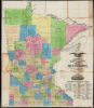

Burritt's Sectional and Township Map of Minnesota.
Minnesota's Homesteader Population Boom.
- Digital Map Information
- Suitable for large format printing
- Full resolution TIFF file
- ICC color profile embedded
- Delivered instantly via download link
Minnesota's Homesteader Population Boom.
This is Elijah H. Burritt and James B. Power's 1871 large-format map of Minnesota. It captures the state in the early post-Civil War period, when immigration from the eastern U.S. and Europe was fueling a period of tremendous growth. Burritt is better known for his popular celestial atlas; this is his only known terrestrial map.A Closer Look
The map displays the state with hand-coloring used to distinguish counties. Survey lines overlay the map, except in the far western and northernmost parts of the state, which remained unsurveyed at the time of publication. Bold red lines trace the boundaries of land districts, each with a land office authorized by the U.S. Congress to handle the sale, preemption, and homesteading of land. County seats, other towns and villages, post offices, waterways, and railroad lines, both completed and under construction, are also indicated. Additionally, the map records the locations of forts, including Fort Abercrombie, and of Indian reservations, namely the White Earth and Red Lake Indian Reservations, reminders of the recent conflict on the frontier and the confinement of Native Americans to reservations.Historical Context
Following the end of the American Civil War (1861 - 1865) and the passage of the Homestead Act of 1862, the population of Minnesota exploded, jumping from roughly 172,000 in 1860 to nearly 440,000 by 1870. This era was defined by a massive influx of Northern European immigrants, particularly Germans, Norwegians, and Swedes. These settlers were drawn by the promise of cheap, fertile land and a climate that, while harsh, felt familiar to their homelands. The state government and private entities even established 'immigration boards' to actively recruit New Yorkers and Europeans, painting Minnesota as a land of boundless opportunity. The Red River Valley, forming Minnesota's border with North Dakota, was particularly popular, seeing the establishment of huge 'bonanza' wheat farms.In addition to nearly limitless farmland, the primary engine of this rapid expansion was the railroad. During the 1870s, rail lines like the Northern Pacific and the Saint Paul and Pacific (the precursor to the Great Northern Railway, discussed below) began to crisscross the prairie. In addition to transporting people and goods, the railroad companies were land developers and town-builders, having been given generous land grants along the planned routes of their lines. These lands were then sold to immigrants to finance further construction. This created a symbiotic cycle; the tracks brought the people, and the people produced the wheat that the trains carried back to mills in Minneapolis.
Finding a Northern Route to the Pacific
Around the time of this map's publication, Minnesota became the epicenter of a frantic push to complete a northern transcontinental railway, a project primarily spearheaded by the Northern Pacific Railroad (NP). After receiving a massive federal land grant, the NP began construction in earnest in 1870 at a junction near Duluth, backed by the significant financial power of Philadelphia banker Jay Cooke. This 'Northern Route' was designed to link the Great Lakes to the Pacific Northwest, transforming the northern Minnesota wilderness into a corridor for global trade. The promise of the railroad produced a frantic atmosphere, as the NP aggressively marketed its land to European immigrants to ensure both a labor force and future freight customers. NP surveyors slogged their way through swamps, bogs, and forests to chart a route through Minnesota and the Dakota Territory. Construction also began on the westernmost portion, linking the Columbia River to Puget Sound. But construction was halted by the financial Panic of 1873, which bankrupted the Northern Pacific. The company had to be reorganized twice, and only minimal construction was undertaken for several years. It was only when Henry Villard (1835 - 1900) took the reins in the early 1880s that the project found its second wind. On September 8, 1883, the 'Gold Spike' was finally driven at Gold Creek, Montana, creating a continuous rail link that transformed the northern frontier from an isolated wilderness into a corridor of commerce, settlement, and industry.Other railroads present here were also integrated into the Transcontinental networks. The Saint Paul and Pacific Railroad was the successor to the Minnesota and Pacific Railroad, the state's first active railroad, which quickly went bankrupt despite generous land grants. The Saint Paul and Pacific also went bankrupt, having been acquired by the original Northern Pacific before the Panic of 1873, and in 1879 reorganized as the St. Paul, Minneapolis and Manitoba Railway. A decade later, James Jerome Hill (1838 - 1916) used the St. Paul, Minneapolis, and Manitoba as the basis for his Great Northern Railway, which was completed in 1893 without federal aid. Likewise, the Winona and St. Peter Railroad, seen here, was purchased by the Chicago and Northwestern Railway Company (CNW) in 1867 and later became the Minnesota division of the CNW. The 'Milwaukee Road' embarked on a costly extension to the Pacific in the early 20th century, much of which was soon electrified, the largest railway electrification project in the world at the time.
Publication History and Census
This map was published by Elijah H. Burritt in 1871, compiling surveys undertaken by James B. Power, chief draughtsman of the U.S. Surveyor's Office in St. Paul. This is, according to our research, the only known terrestrial map published by Burritt, his other work being mostly star and constellation maps. The map was printed by the St. Paul Lithograph and Engraving Co. There are at least two editions, both copyrighted to 1870 but with differing dates below the title (1870 and 1871, respectively). Examples of the 1871 edition are variously published by Burritt alone as here, Burritt and Pease, or (G. Jay) Rice and Reed. The map is quite rare in either edition, being cataloged at 8 institutions in OCLC.Cartographers
Elijah Hinsdale Burritt II (July 11, 1835 - 1879) was a bookseller and publisher active in St. Paul, Minnesota in the late 1860s - early 1870s. He is the son of the surveyor and astronmical atlas publisher of the same name Elijah Hinsdale Burritt (1794 - 1838). He was born in New Britain, Connecticut. It is unclear when the bookseller Elijah H. Burritt came to Minnesota, but he was already present and considered a 'leading man' of St. Paul by 1862, having worked as a Clerk of the Supreme Court of Minnesota. That year, he joined as First Assistant an overland expedition from St. Paul, Minnesota to Portland, Oregon, led by Captain James Fisk. Fisk was a vocal proponent of westward expansion and settlement and had been granted an officer's commission by the Union Army and given free rein to protect emigrants settling on the frontier of Minnesota. After this adventure, Burritt was appointed a Clerk of the Sioux Indemnity Commission in St. Paul, which was established following the Dakota War of 1862. His subsequent activities are unclear, but he was active as a publisher and bookseller in the late 1860s - early 1870s, sometimes under his own name, sometimes as 'E. H. Burritt and Co.,' and, from 1871, as 'Burritt and Pease,' which provided stationary and 'sundries' to the state government, among others. Burritt primarily published educational material and works relating to Minnesota, such as maps and emigrants' guides. Burritt was an officer of the Republican Club of Ramsey County and a representative from the county to at least one State Republican Convention. Further Details...
James Buel Power (August 20, 1833 - December 16, 1912) was a draughtsman and land commissioner active in Minnesota and North Dakota in the late 19th and early 20th century. Born in Stockport, New York, Power moved around New York and New England in his youth, working as a ticket clerk on the New York and Erie Railway. In 1851, he began working in the Civil Engineering Department of the St. Louis and Pacific Railroad. After a brief stint in Missouri, Power returned to New York to work as head engineer on the Susquehanna division of the New York and Erie Railway. In 1857, Power married Helen Amelia Buckhout, with whom he would have five children. Soon afterwards, the newlyweds moved to the frontier, settling in Janesville, Minnesota, where Power worked as Chief of the Land Office in the Auditor's Office of Minnesota, and then St. Paul in 1862, when he became Deputy State Treasurer. In 1867, Power was appointed Chief Draftsman in the U.S. Surveyor's Office in St. Paul and in 1871 he was appointed the first Land Commissioner of the Northern Pacific Railway, becoming the General Agent for the Minnesota and Dakota division in 1873. With the Northern Pacific, Power was a major promoter of the purchase of land for the bonanza farms in the Red River Valley following the 1873 depression. He himself bought a large 6,000 acre plot he dubbed the Helendale Stock Farm (a small community within Helendale later being called Power after his family). In 1881, Power became Land Commissioner of the St. Paul, Minneapolis, and Manitoba (Great Northern) Railway and then briefly worked as the Secretary and Treasurer of the South St. Paul Stockyards in 1885 before retiring. Considered an expert on agricultural and land issues in the territory (state from 1889), Power was appointed to several important positions with the Board of Agriculture, State Board of Public Lands, and the North Dakota Agricultural College (now North Dakota State University, where his papers are kept), of which he was President from 1893 to 1895. Afterwards, he served in the North Dakota House of Representatives. Power traveled back and forth regularly between his farm in North Dakota and St. Paul, dying at the former and being buried in the latter. Further Details...
St. Paul Lithograph and Engraving Co. (St. Paul Lithographic and Engraving Co.; fl. c. 1870 - 1891) was a lithographic printer active in St. Paul, Minnesota in the late 19th century. The firm primarily produced maps of the State of Minnesota and its major cities, including Minneapolis and St. Paul, working with a range of map publishers active in the state during the 1870s and 1880s. The firm was likely founded and for its known period of operation managed by one William Silcock, resident in St. Paul from about 1870 to 1900 and listed in city directories as a lithographer, printer, or transferer. Further Details...
Condition
Good. Areas of brittleness and toning; Mended splits at several folds, some loss at junctures of folds and to insertion panel.
References
OCLC 7522776, 69226867, 1324034836. Karrow, R. W. (ed.), Erickson, N. (comp.), Checklist of Printed Maps of the Middle West to 1900, Volume 7: Minnesota, (Chicago: G.K. Hall) 1981, # 0809.