1804 Neele / Boisgelin Map of Malta and Gozo
MaltaGozo-neele-1804$4,000.00


Title
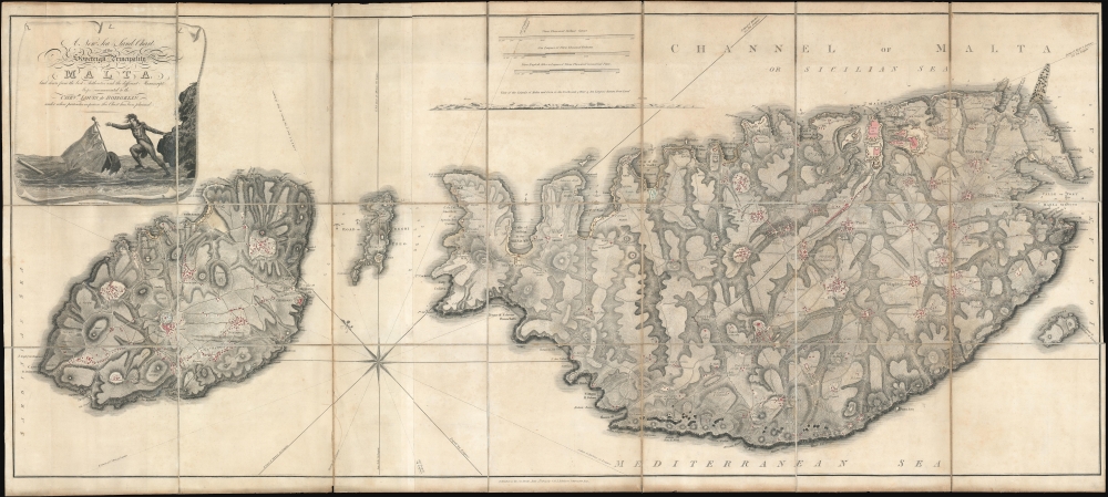
A New Sea and Land Chart of the Sovereign Principality of Malta; laid down from the best Authorities and the different Manuscript Maps communicated to the Chevr. Louis de Boisgelin under whose particular inspection this Chart has been planned.
1804 (dated) 23.5 x 52.25 in (59.69 x 132.715 cm) 1 : 35000
1804 (dated) 23.5 x 52.25 in (59.69 x 132.715 cm) 1 : 35000
Description
A spectacular discovery, this 1804 production is the largest and most detailed map of Malta to appear in the 19th century. The map was produced by Pierre Marie Louis de Boisgelin de Kerdu and Samuel John Neele based upon Boisgelin's lifetime of experience in Malta as a member of the knightly monastic Order of St. John. The map is matched in dimensions and sophistication only by the Carte Generale de la Principaute Souveraine des Isles de Malte et du Goze (53.1 x 22.8 inches), made by Gervais de Palmeus in 1752.
On the Map
Oriented to the northeast - unusual for maps of Malta which typically have the opposite orientation. Fine engraving employing hachuring illustrates the island's topography. Some depth soundings are included, particularly around the important harbor of Valetta. The detail is impressive, with important buildings and streets in every town and village on the island noted. An evocative cartouche is featured in the upper right.The Knights of St. John in Dire Straits
An evocative cartouche is featured in the upper right. It figures a Knight of the Order of St. John reaching for a sinking ship. This directly relates to the dire circumstances of the knightly order in 1805. The Order was unpopular with the French Revolutionaries, who saw it as a hold out of the established nobility - which it was. The National Convention seized the order's possessions in France in 1792, shortly after taking power. When Napoleon Bonaparte invaded Malta in 1798, he expelled the order, whose members fled to various parts of Europe. As French influence, under Napoleon, spread throughout continental Europe, more of the Order's possessions were seized, leaving it with few assets and a diaspora membership. England seized control of Malta in 1800 and agreed to return Malta to the Order in 1802-3, but this never materialized. Today the Order is based in Rome but maintains limited extraterritoriality at upper portion of Fort St. Angelo in the city of Birgu, Malta.Sovereign Military Hospitaller Order of Saint John of Jerusalem, of Rhodes and of Malta
The Knights of St. John or the Sovereign Military Order of Malta (SMOM) is a Catholic lay religious order, traditionally of military, chivalric, and noble nature. The organization claims continuity to the Knights Hospitalier, a Crusading chivalric order that was founded c. 1099 by the Blessed Gerard in medieval Jerusalem. The headquarters of the Order of Saint John had been in Malta from 1530 until 1798. During the French Occupation, in 1798, the Order was expelled from Malta, its members fleeing to various parts of Europe. The Order's rights were reasserted in 1879, when the Grand Magisterium of Malta was restored by order of Pope Leo XIII. Although not recognized by the United Nations, the Order is essentially an independent political entity comprising some 13,500 members. They remain true to their mediaeval roots, running hospitals throughout Europe and employing some 42,000 doctors and 80,00 volunteers in more than 120 countries.Publication History and Census
This map was prepared by Samuel John Neele under the supervision of Pierre Marie Louis de Boisgelin de Kerdu. It was engraved and printed by the firm of G. and J. Robinson. The work was intended to compliment and illustrate Boisgelin's Ancient and Modern Malta, but was often, as here, also issued separately. Examples are scarce to the market, appearing roughly once every two or three years.CartographerS
Pierre Marie Louis de Boisgelin de Kerdu (May 5, 1758 - September 9, 1816), also known as Caillot-Duval, was a French writer and militant monk. He was born at the Château de la Ville-Balin in Plélo, France. He studied at the seminary of Sant-Sulpice until 1782 when he was presented to the Order of St. John of Jerusalem, a Malta based militant monastic knightly order related to the Knights Templar. He left the Knights of St. John in 1793, but remained in Malta. When Malta was occupied by the French under Napoleon Bonaparte, in 1798, he joined the French armies. When the English retook the archipelago, in 1800, he fled to Toulon. There, he joined royalist forces, organizing with the support of Louis XVIII, the 'Royal Louis' regiment. When they were defeated by the Republican Army, Boisgelin fled to England, where he wrote and published his 1804, Ancient and Modern Malta and a supplementary large-scale map of Malta - the best yet seen. He returned to France in 1805 where he lived out the remainder of his days. His personal library and literary work were bequeathed to the Méjanes Library in Aix-en-Provence. More by this mapmaker...
Samuel John Neele (July 29, 1758 - May 13, 1824) was a prolific British map engraver active in the late 18th and early 19th centuries. Neele apprenticed as a printer and engraver with Harry Ashby from about 1781 to 1782 before establishing himself independently in 1785 at 352 Strand, London. The combination of business acumen and technical skill made Neele extremely successful with literally hundreds of maps to his credit. His vast corpus was composed of notable maps by most major English publishers of the period including, Haywood, Faden, Wallis, Stockdale, Arrowsmith, Thomson, Pinkerton, and Greenwood, among others. Neele's sons, James and Josiah Neele, also engravers, took over their fathers business around 1818, both becoming notable in their own right. Learn More...
G. and J. Robinson (fl. 1785 - 1818) were Scottish book, magazine, and map publishers active in the late 18th and early 19th centuries. The firm was based at 25 Paternoster Row, London. From about 1809, it was run exclusively by G. Robinson. The firm, at various points, consisted of George Robinson (the elder) the 'King of Booksellers', George Robinson (the younger), John Robinson, and James Robinson. It was George Robinson, the younger, who continued to run the firm solo after 1909. Learn More...
Condition
Very good. Dissected and mounted on linen in four panels. Original linen. Some wear to old linen.
References
OCLC 63573807.