1904 Hausermann Map of Catholic Missions in Mainland Southeast Asia
MissionsSiam-hausermann-1904$650.00


Title
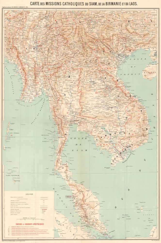
Carte des Missions Catholiques du Siam, de la Birmanie et du Laos.
1904 (dated) 38.5 x 24.75 in (97.79 x 62.865 cm) 1 : 3000000
1904 (dated) 38.5 x 24.75 in (97.79 x 62.865 cm) 1 : 3000000
Description
A colorful, large-format chromolithographed 1904 map of mainland Southeast Asia engraved by Rémy Hausermann and printed by Jean Noël Monrocq as a supplement to the missionary periodical Les Missions Catholiques. While also an excellent topographic map, its main focus is on the Catholic missionary territories (vicariats apostoliques) of the Missions Etrangères de Paris (MEP) in the region.
The main focus of the map is the division of apostolic mission territories of the Missions Etrangères de Paris in Malaya, Siam, Burma, and Laos. Symbols in the legend indicate the apostolic status of different mission sites, from bishoprics and apostolic vicariates (equivalent in terms of hierarchy but distinguished by whether the apostolic territory was an established diocese or still a vicariate being targeted for missionary work) to small congregations or centers of Christianity perhaps even lacking a chapel (and likely only seldom visited by a missionary). Although, as the map indicates, the MEP had a lock on apostolic administration of this region, other Catholic mission orders were also active, running schools, hospitals, and other charitable works. The situation in Vietnam (Cochinchine, Annam, and Tonkin) was quite different, with a much larger number of Catholics and a more varied landscape of apostolic administration
In any event, the relationship between Church and State was surprisingly cozy given their intense domestic political struggles during the Third Republic. Around the time this map was produced, France was deep in the throes of a battle over Church-State relations and moving towards strict anticlericalism in the wake of the Dreyfus Affair, but abroad, one would hardly know there was any tension at all; in fact, French diplomats and missionaries actively and enthusiastically collaborated to promote France's mission civilisatrice.
A Closer Look
Coverage ranges from the Burma-India borderlands to China (Guangxi Province, here as Kouang Si) and southwards to Singapore and part of Sumatra. Topographic detail is noted by relief, shading, and color, giving a clear sense of the rapid interchange between steep mountains and valleys in the region. Cities and towns, islands, bodies of water, railways (existing and under construction), and other features are noted in great detail. The Yunnan-Haiphong Railway (completed in 1910) is traced, leading ultimately to Kunming (here as 'Yunnan Sen'). An equally ambitious French railway scheme to link Bangkok to Saigon via Pnom Penh never materialized.The main focus of the map is the division of apostolic mission territories of the Missions Etrangères de Paris in Malaya, Siam, Burma, and Laos. Symbols in the legend indicate the apostolic status of different mission sites, from bishoprics and apostolic vicariates (equivalent in terms of hierarchy but distinguished by whether the apostolic territory was an established diocese or still a vicariate being targeted for missionary work) to small congregations or centers of Christianity perhaps even lacking a chapel (and likely only seldom visited by a missionary). Although, as the map indicates, the MEP had a lock on apostolic administration of this region, other Catholic mission orders were also active, running schools, hospitals, and other charitable works. The situation in Vietnam (Cochinchine, Annam, and Tonkin) was quite different, with a much larger number of Catholics and a more varied landscape of apostolic administration
The MEP and Asia Missions in the Third Republic
The MEP was created in the 17th century to avoid the perceived weaknesses of (or perhaps challenge) the established religious orders such as the Jesuits and Dominicans, who were seen as having mishandled the evangelization of Japan in particular, resulting in severe anti-Christian persecution. Instead, the MEP would consist of secular clergy (not members of religious orders) and laity who worked closely with the Sacred Congregation for the Propagation of the Faith (Propaganda Fide), the Holy See's body for managing missionary work. The organization is also unusual for being so explicitly tied to a particular nationality rather than being self-consciously international. The MEP quickly developed a focus on evangelization in Asia and tended to operate in dangerous environments (often in direct contravention of the laws of Asian kingdoms), sometimes becoming directly embroiled in succession disputes and rebellions. Attacks on MEP missionaries were a common justification for French military action in Annam, Tonkin, China, and Korea. Historians have argued whether the missionaries were deliberately encouraged to get themselves martyred by the French state or whether it was the missionaries exploiting the French state for their own benefit.In any event, the relationship between Church and State was surprisingly cozy given their intense domestic political struggles during the Third Republic. Around the time this map was produced, France was deep in the throes of a battle over Church-State relations and moving towards strict anticlericalism in the wake of the Dreyfus Affair, but abroad, one would hardly know there was any tension at all; in fact, French diplomats and missionaries actively and enthusiastically collaborated to promote France's mission civilisatrice.
Publication History and Census
This map was engraved by Rémy Hausermann and printed by Jean Noël Monrocq as a supplement to the 1904 volume of the French missionary periodical Les Missions Catholiques (bulletin hebdomadaire de l'Oeuvre de la propagation de la foi). The map did not accompany an article, as was often the case, but a short note in the volume explains that this is the first map of the region produced by Les Missions Catholiques and includes a brief description of the different territories mentioned in the title and the presence of Christians (Catholics) there. This map is cataloged among the holdings of 12 institutions in the OCLC, only two of which (the New York Public Library and the Universidad Iberoamericana) are outside of Europe (the University of Hawaii catalogs a digital example, but it is unclear if it also holds a physical example).CartographerS
Rémy Hausermann (1843 - 1933) was a French map engraver who, among other roles, was the main engraver for the Missions Catholiques de Lyon, allowing him to introduce the geography of areas previously little known or unknown to a European audience. Little is known about his early life and training, but by 1879 he was the Vice President of the Congrès des Sciences géographiques. He was well-known and well-regarded in geographical study circles in the late 19th century, writing school textbooks on the subject and receiving accolades at the 1878 exposition universelle in Paris. More by this mapmaker...
Jean Noël Monrocq (December 25, 1819 - February 18, 1913) was a French printer and bookseller active in Paris in the mid to late 19th century. Monrocq was born on Chrismtas day, hence his name, in Trelly, La Manche, the son of a farmer. In 1839 he moved to Paris for a more urban lifestyle. Although he had little formal education, he found work with the Parisian book and print seller Delarue. Meating some success, he opened his own print shop in 1848. He initially applied for a booksellers patent in 1853, but the application was initially rejected. It was formally approved in 1877. In 1859, he received a lithographers patent for artistic and industrial prints for education purposes. He took over the presses of Louis Etienne Stanislas Petit in 1859, but did not relieve a formal intaglio imprint until 1865. In March 1874, he established a branch of his lithographic printing press in Ivry, Rue de Vitry, where he moved part of his equipment. He became known for zincographic lithography - the process of etching plates into zinc, which he claimed falsely to have invented. He did nonetheless, contributed significantly to the industrialization of the printing with zinc plates. Being cheap, simple to make, easy to modify, zinc plates became the standard for news printing. Zincography under Monrocq was also ideally suited to map production. The Monrocq produced a significant corpus of maps. The firm spearheaded the movement to centralize map production in France. The firm continued well after his death, issuing maps for both Hachette Taride. For a long time, his son, Léon Monrocq (1857 - 1902) worked with him specifically printing maps, unfortunately he died young. The firm for a time was operated by the founder's son-in-law, who took the name Gaillac-Monrocq. Jean Noël Monrocq's grandson Lucien Monrocq, eventually took over the publishing arm of the firm. Learn More...
Source
Les Missions catholiques : revue générale illustrée de toutes les missions, Vol. 13, (Lyon: Oeuvre de la propagation de la foi) 1882.
Condition
Very good. A few minor wormholes and edge reinforcements.
References
OCLC 557668560, 902293372.