Digital Image: 1904 Hausermann Map of Catholic Missions in Mainland Southeast Asia
MissionsSiam-hausermann-1904_d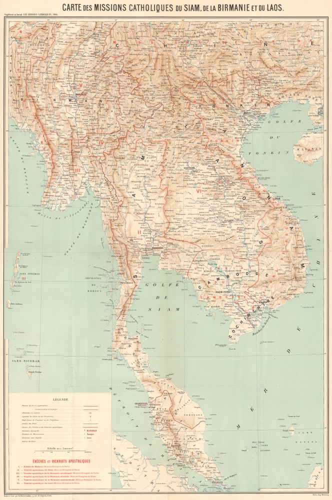


Title
Carte des Missions Catholiques du Siam, de la Birmanie et du Laos.
1904 (dated) 38.5 x 24.75 in (97.79 x 62.865 cm) 1 : 3000000
1904 (dated) 38.5 x 24.75 in (97.79 x 62.865 cm) 1 : 3000000
Description
FOR THE ORIGINAL ANTIQUE MAP, WITH HISTORICAL ANALYSIS, CLICK HERE.
Digital Map Information
Geographicus maintains an archive of high-resolution rare map scans. We scan our maps at 300 DPI or higher, with newer images being 600 DPI, (either TIFF or JPEG, depending on when the scan was done) which is most cases in suitable for enlargement and printing.
Delivery
Once you purchase our digital scan service, you will receive a download link via email - usually within seconds. Digital orders are delivered as ZIP files, an industry standard file compression protocol that any computer should be able to unpack. Some of our files are very large, and can take some time to download. Most files are saved into your computer's 'Downloads' folder. All delivery is electronic. No physical product is shipped.
Credit and Scope of Use
You can use your digial image any way you want! Our digital images are unrestricted by copyright and can be used, modified, and published freely. The textual description that accompanies the original antique map is not included in the sale of digital images and remains protected by copyright. That said, we put significant care and effort into scanning and editing these maps, and we’d appreciate a credit when possible. Should you wish to credit us, please use the following credit line:
Courtesy of Geographicus Rare Antique Maps (https://www.geographicus.com).
How Large Can I Print?
In general, at 300 DPI, you should at least be able to double the size of the actual image, more so with our 600 DPI images. So, if the original was 10 x 12 inches, you can print at 20 x 24 inches, without quality loss. If your display requirements can accommodate some loss in image quality, you can make it even larger. That being said, no quality of scan will allow you to blow up at 10 x 12 inch map to wall size without significant quality loss. For more information, it is best consult a printer or reprographics specialist.
Refunds
If the high resolution image you ordered is unavailable, we will fully refund your purchase. Otherwise, digital images scans are a service, not a tangible product, and cannot be returned or refunded once the download link is used.
Cartographer S
Rémy Hausermann (1843 - 1933) was a French map engraver who, among other roles, was the main engraver for the Missions Catholiques de Lyon, allowing him to introduce the geography of areas previously little known or unknown to a European audience. Little is known about his early life and training, but by 1879 he was the Vice President of the Congrès des Sciences géographiques. He was well-known and well-regarded in geographical study circles in the late 19th century, writing school textbooks on the subject and receiving accolades at the 1878 exposition universelle in Paris. More by this mapmaker...
Jean Noël Monrocq (December 25, 1819 - February 18, 1913) was a French printer and bookseller active in Paris in the mid to late 19th century. Monrocq was born on Chrismtas day, hence his name, in Trelly, La Manche, the son of a farmer. In 1839 he moved to Paris for a more urban lifestyle. Although he had little formal education, he found work with the Parisian book and print seller Delarue. Meating some success, he opened his own print shop in 1848. He initially applied for a booksellers patent in 1853, but the application was initially rejected. It was formally approved in 1877. In 1859, he received a lithographers patent for artistic and industrial prints for education purposes. He took over the presses of Louis Etienne Stanislas Petit in 1859, but did not relieve a formal intaglio imprint until 1865. In March 1874, he established a branch of his lithographic printing press in Ivry, Rue de Vitry, where he moved part of his equipment. He became known for zincographic lithography - the process of etching plates into zinc, which he claimed falsely to have invented. He did nonetheless, contributed significantly to the industrialization of the printing with zinc plates. Being cheap, simple to make, easy to modify, zinc plates became the standard for news printing. Zincography under Monrocq was also ideally suited to map production. The Monrocq produced a significant corpus of maps. The firm spearheaded the movement to centralize map production in France. The firm continued well after his death, issuing maps for both Hachette Taride. For a long time, his son, Léon Monrocq (1857 - 1902) worked with him specifically printing maps, unfortunately he died young. The firm for a time was operated by the founder's son-in-law, who took the name Gaillac-Monrocq. Jean Noël Monrocq's grandson Lucien Monrocq, eventually took over the publishing arm of the firm. Learn More...
Source
Les Missions catholiques : revue générale illustrée de toutes les missions, Vol. 13, (Lyon: Oeuvre de la propagation de la foi) 1882.
References
OCLC 557668560, 902293372.