This item has been sold, but you can get on the Waitlist to be notified if another example becomes available, or purchase a digital scan.
1720 Homann Map of the Mississippi Valley and British Colonies
Mississipi2-homann-1720$1,000.00

Title
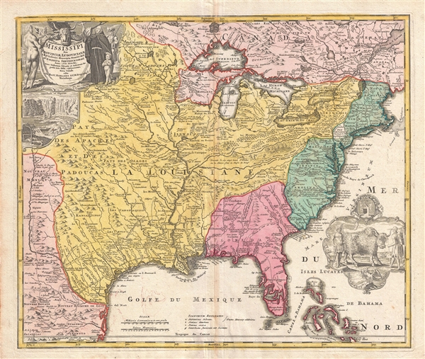
Amplissimae Regionis Mississipi seu Provinciae Ludovicianae a R.P. Ludovico Hennepin Francisc Miss in America Septentrionali Anno 1687. Detectae, Nunc Gallorum Coloniis et Actionum Negotiis Toto Orbe Celeberrimae.
1720 (undated) 19 x 22.5 in (48.26 x 57.15 cm) 1 : 7200000
1720 (undated) 19 x 22.5 in (48.26 x 57.15 cm) 1 : 7200000
Description
An iconic c. 1720 map of the Mississippi River Valley by Johann Baptiste Homan. Commonly called the 'Buffalo Map' for its distinctive decorative elements depicting a stylized buffalo, this map is derived from an earlier 1718 map of the same region by G. De L'Isle though it has been enlarged to include New England. The map covers much of the modern day United States from Canada and the Great Lakes to the Florida Keys and from Mexico and Texas to the Pacific. According to the political conventions of the time this map is segmented into various zones including New Mexico (red) along the Rio de Norte (Rio Grande), Louisiana (yellow) covering a vast area including Texas, all five of the Great Lakes, and both the upper and lower Mississippi River Valleys, Florida (red) consisting most of the American southeast, the English Colonies (green) along the Atlantic seaboard, and Canada (red) stretching across the top of the map north of the Great Lakes. Various explorers' routes (including de Soto) are noted, as are mission settlements, American Indian villages, fortifications, and portages. Florida is depicted as an archipelago inhabited by anthropophagi (cannibals). The cartouche work, in the upper left quadrant, details Niagara Falls as well as various allegorical illustrations. A secondary cartouche, showing American Indians and a stylized buffalo appears in the lower right.
This map enjoyed a long production run and was extremely popular throughout europe – most likely for its decorative inclusion of the American Buffalo and Niagara Falls, objects of fascination for many 18th century europeans. Though this map was issued in only one edition, it was published in Homann's Neuer Atlas, the Atlas Major, and many other composite atlases well into the late 1700s, making specific instances of the map all but possible to date with precision. Most examples thus reference the original publication date, c. 1720.
This map enjoyed a long production run and was extremely popular throughout europe – most likely for its decorative inclusion of the American Buffalo and Niagara Falls, objects of fascination for many 18th century europeans. Though this map was issued in only one edition, it was published in Homann's Neuer Atlas, the Atlas Major, and many other composite atlases well into the late 1700s, making specific instances of the map all but possible to date with precision. Most examples thus reference the original publication date, c. 1720.
Cartographer
Johann Baptist Homann (March 20, 1664 - July 1, 1724) was the most prominent and prolific map publisher of the 18th century. Homann was born in Oberkammlach, a small town near Kammlach, Bavaria, Germany. As a young man, Homann studied in a Jesuit school and nursed ambitions of becoming a Dominican priest. Nonetheless, he converted to Protestantism in 1687, when he was 23. It is not clear where he mastered engraving, but we believe it may have been in Amsterdam. Homann's earliest work we have identified is about 1689, and already exhibits a high degree of mastery. Around 1691, Homann moved to Nuremberg and registered as a notary. By this time, he was already making maps, and very good ones at that. He produced a map of the environs of Nürnberg in 1691/92, which suggests he was already a master engraver. Around 1693, Homann briefly relocated to Vienna, where he lived and studied printing and copper plate engraving until 1695. Until 1702, he worked in Nuremberg in the map trade under Jacob von Sandrart (1630 - 1708) and then David Funck (1642 - 1709). Afterward, he returned to Nuremberg, where, in 1702, he founded the commercial publishing firm that would bear his name. In the next five years, Homann produced hundreds of maps and developed a distinctive style characterized by heavy, detailed engraving, elaborate allegorical cartouche work, and vivid hand color. Due to the lower cost of printing in Germany, the Homann firm could undercut the dominant French and Dutch publishing houses while matching their diversity and quality. Despite copious output, Homann did not release his first major atlas until the 33-map Neuer Atlas of 1707, followed by a 60-map edition of 1710. By 1715, Homann's rising star caught the attention of the Holy Roman Emperor Charles VI, who appointed him Imperial Cartographer. In the same year, he was also appointed a member of the Royal Academy of Sciences in Berlin. Homann's prestigious title came with several significant advantages, including access to the most up-to-date cartographic information as well as the 'Privilege'. The Privilege was a type of early copyright offered to very few by the Holy Roman Emperor. Though less sophisticated than modern copyright legislation, the Privilege offered limited protection for several years. Most all J. B. Homann maps printed between 1715 and 1730 bear the inscription 'Cum Priviligio' or some variation. Following Homann's death in 1724, the firm's map plates and management passed to his son, Johann Christoph Homann (1703 - 1730). J. C. Homann, perhaps realizing that he would not long survive his father, stipulated in his will that the company would be inherited by his two head managers, Johann Georg Ebersberger (1695 - 1760) and Johann Michael Franz (1700 - 1761), and that it would publish only under the name 'Homann Heirs'. This designation, in various forms (Homannsche Heirs, Heritiers de Homann, Lat Homannianos Herod, Homannschen Erben, etc.) appears on maps from about 1731 onwards. The firm continued to publish maps in ever-diminishing quantities until the death of its last owner, Christoph Franz Fembo (1781 - 1848). More by this mapmaker...
Source
Homann, J. B., Neuer Atlas bestehend in einig curieusen Astronomischen Kuppren und vielen auserlesenen accuratensten Land-Charten über die Gantze Welt, (Nuremberg: Homann), 1716.
Homann's Neuer Atlas bestehend in einig curieusen Astronomischen Kuppren und vielen auserlesenen accuratensten Land-Charten über die Gantze Welt was first publihsed in 1707 with 33 maps. A second edition followed in 1710 with 60 maps. Subsequent editions followed until about 1730. The title page notes proudly that the atlas features measurements based on the 'Copernican principle of the moving sky', a truly state-of-the-art innovation for the period. Regardless of editions, collations of the atlas are inconsistent, with some examples having less, while others have more maps - a consequence of the fact that the map sheets were delivered loose, to be bound at the buyer's discretion, and so some buyers chose to omit maps they did not consider relevant, or add others they did. Between editions, the constituent maps, particularly of European regions, were regularly updated to reflect the most recent political events. The atlas continued to be published by Homann's son, J. C. Homann (1703 - 1730), and then by Homann Heirs. Most examples also feature a fine allegorical frontispiece with the title Atlas Novus Terrarum Orbis Imperia, regna et Status, which was used for multiple Homann atlases, including the Neuer Atlas and the Atlas Minor.
Condition
Very good. Verso reinforcement along original centerfold. Original centerfold exhibits some wear.
References
OCLC 698853005. Cumming, W., The Southeast in Early Maps, no. 170. Wheat, C. I., Mapping of the Transmississippi West, 1540 – 1861, 144. Goss, J., The Mapping of North America: Thre Centuries of Map-Making 1500-1860, #49. McCorkle, B. B, New England in Early Printed Maps 1513 - 1800, 720.1. Sellers, John R. and Van Ee, Patricia, Maps and Charts of North America, no. 102. Lowery, W., The Lowery Collection, 475. Day, J. M., Maps of Texas, 1527-1900: The Map Collection of the Texas State Archives, 401.