This item has been sold, but you can get on the Waitlist to be notified if another example becomes available, or purchase a digital scan.
1900 / 1906 U.S.C.G.S. Chart of Western Mississippi Sound, Gulfport, Biloxi
MississippiSoundWest-uscgs-1900$475.00


Title
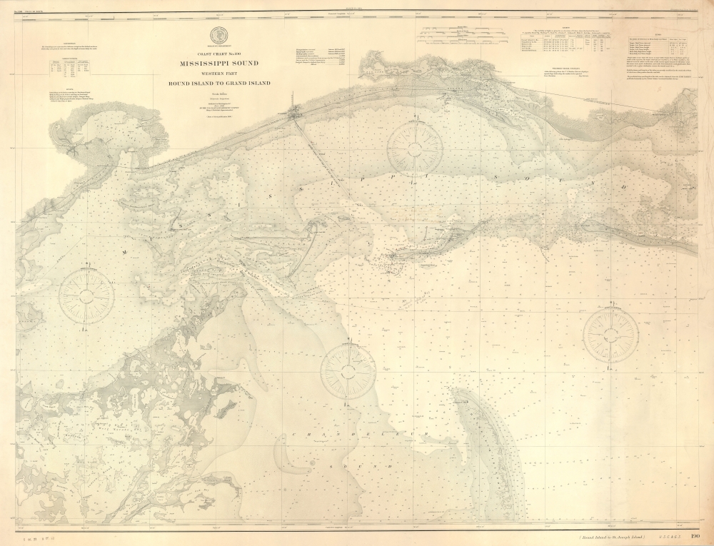
Coast Chart No. 190 Mississippi Sound Western Part Round Island to Grand Island.
1900 (dated) 32.5 x 42.5 in (82.55 x 107.95 cm) 1 : 80000
1900 (dated) 32.5 x 42.5 in (82.55 x 107.95 cm) 1 : 80000
Description
A scarce, unrecorded 1900 (c. 1906) edition of the U.S. Coast and Geodetic Survey chart of the western part of the Mississippi Sound. While charts of the Gulf Coast generally are not uncommon, very few address this part of the Mississippi Sound with such detail, giving this chart a unique focus on a favored fishing haunt.
This chart does not appear in any institutional collections and has no known history on the market, though it is mentioned in the 1920 Catalog of U.S. Coast and Geodetic Survey Nautical Charts as being published in 1908. Stamps from 1928 appear in the margin at bottom-left but were almost certainly added long after publication. The plate number noted at top, along with the mention of this chart as an electrotype copy at top-right, suggest that this example appeared in a larger atlas or collection of charts. A corresponding eastern sheet does exist (1860 edition previously sold by us), but if published in the early 20th century is equally rare. Both charts exist as standalone works but were designed to be joined like a large blueback into a huge rolling chart, which some mariners preferred.
A Closer Look
The chart covers the coast of Mississippi, roughly from Treasure Bay, Live Oak Bay, and St. Louis Bay, eastward past Biloxi and as far as the Pascagoula River. It provides extraordinary detail throughout, including sailing instructions, notes on tides, winds, and bottoms, identification of various lighthouses and buoys, illustration of shoals, and thousands of depth soundings. On land, towns, cities, and individual buildings are indicated, along with terrain, roads, and railways.The Birth of Gulfport
Of particular importance is the recently-dredged shipping channel emanating from Gulfport. The city had been founded in 1898 by the Gulf and Ship Island Railroad as an outlet for timber harvested inland to be shipped by sea. At Gulfport, the G. and S.I.R.R. intersected the Louisville and Nashville Railroad, increasing the city's economic importance even more. As a result, Gulfport grew rapidly to eclipse nearby Biloxi in just a handful of years. In 1904, the city was given a further boost as the Treasury Department designated it the port of entry on that portion of the Gulf of Mexico, replacing Shieldsboro, on the western side of St. Louis Bay, and a new post office and customshouse was built in 1910.Manuscript Annotations
Faint handwriting, especially around Ship Island, indicates that this chart saw use on the seas. Only fragments of the large block of text north of Ship Island are legible, such as 'good berth' and 'go to [?] before heading off north,' which would strongly suggest the notes relate to tips for navigating the coastal waters of this portion of the Gulf of Mexico. South of Ship Island is a more legible note about anchoring there on April 28, 1907, and another anchor point is marked just north of west side of island.Publication History and Census
This chart was originally surveyed and drawn in 1860, though it was not published until after the U.S. Civil War (1861 - 1865), in the 1867 supplement to the 1866 edition of the Superintendent's Report. It was later reprinted as Coastal Chart No. 90, unchanged but with different pagination, and then the present edition was produced in the early 20th century. Though noted as being 'Published 1900,' the list of surveys and observations to the right of the title mentions work done up to 1904, while the map itself notes the channel dredged from Gulfport in 1905. Since the manuscript annotations mention a date in 1907, this example was presumably published between 1905 and 1907.This chart does not appear in any institutional collections and has no known history on the market, though it is mentioned in the 1920 Catalog of U.S. Coast and Geodetic Survey Nautical Charts as being published in 1908. Stamps from 1928 appear in the margin at bottom-left but were almost certainly added long after publication. The plate number noted at top, along with the mention of this chart as an electrotype copy at top-right, suggest that this example appeared in a larger atlas or collection of charts. A corresponding eastern sheet does exist (1860 edition previously sold by us), but if published in the early 20th century is equally rare. Both charts exist as standalone works but were designed to be joined like a large blueback into a huge rolling chart, which some mariners preferred.
CartographerS
The Office of the Coast Survey (1807 - present) founded in 1807 by President Thomas Jefferson and Secretary of Commerce Albert Gallatin, is the oldest scientific organization in the U.S. Federal Government. Jefferson created the "Survey of the Coast," as it was then called, in response to a need for accurate navigational charts of the new nation's coasts and harbors. The spirit of the Coast Survey was defined by its first two superintendents. The first superintendent of the Coast Survey was Swiss immigrant and West Point mathematics professor Ferdinand Hassler. Under the direction of Hassler, from 1816 to 1843, the ideological and scientific foundations for the Coast Survey were established. These included using the most advanced techniques and most sophisticated equipment as well as an unstinting attention to detail. Hassler devised a labor intensive triangulation system whereby the entire coast was divided into a series of enormous triangles. These were in turn subdivided into smaller triangulation units that were then individually surveyed. Employing this exacting technique on such a massive scale had never before been attempted. Consequently, Hassler and the Coast Survey under him developed a reputation for uncompromising dedication to the principles of accuracy and excellence. Unfortunately, despite being a masterful surveyor, Hassler was abrasive and politically unpopular, twice losing congressional funding for the Coast Survey. Nonetheless, Hassler led the Coast Survey until his death in 1843, at which time Alexander Dallas Bache, a great-grandson of Benjamin Franklin, took the helm. Bache was fully dedicated to the principles established by Hassler, but proved more politically astute and successfully lobbied Congress to liberally fund the endeavor. Under the leadership of A. D. Bache, the Coast Survey completed its most important work. Moreover, during his long tenure with the Coast Survey, from 1843 to 1865, Bache was a steadfast advocate of American science and navigation and in fact founded the American Academy of Sciences. Bache was succeeded by Benjamin Pierce who ran the Survey from 1867 to 1874. Pierce was in turn succeeded by Carlile Pollock Patterson who was Superintendent from 1874 to 1881. In 1878, under Patterson's superintendence, the U.S. Coast Survey was reorganized as the U.S. Coast and Geodetic Survey (C & GS) to accommodate topographic as well as nautical surveys. Today the Coast Survey is part of the National Oceanic and Atmospheric Administration or NOAA as the National Geodetic Survey. More by this mapmaker...
Henry Smith Pritchett (April 16, 1857 - August 28, 1939) was an American astronomer and educator. Born in Fayette, Missouri, Pritchett attended Pritchett College in Glasgow, Missouri and graduated with a B.A. in 1875. He then spent two years at the U.S. Naval Observatory under the tutelage of Asaph Hall, after which he became an assistant astronomer. He returned to Glasgow in 1880 for a job at the Morrison Observatory, where his father was the director. In 1882, Pritchett served as an astronomer on the Transit of Venus Expedition to New Zealand, and was appointed as a professor of mathematics and astronomy at Washington University in St. Louis upon his return in 1883. While at Washington University, Pritchett also served as the director of the observatory. Pritchett studied in Germany in the early 1890s and earned a PhD from the University of Munich in 1894. From December 1, 1897 until November 30, 1900, Pritchett was the Superintendent of the U.S. Coast and Geodetic Survey, and then was president of the Massachusetts Institute of Technology (MIT) from 1900 until 1906. After leaving MIT, Pritchett served as the president of the Carnegie Foundation for the Advancement of Teaching from 1906 until he retired in 1930. Learn More...
Condition
Good. Some discoloration right side. Minor margin tear from right side, repaired and stabilized on verso.