This item has been sold, but you can get on the Waitlist to be notified if another example becomes available, or purchase a digital scan.
1942 Faller Pictorial WWII Route Map of the German 5th Infantry Div. on the Eastern Front
MitUnsImOsten-faller-1942$397.50


Title
Mit Uns Im Osten.
1942 (dated) 19.75 x 43.75 in (50.165 x 111.125 cm)
1942 (dated) 19.75 x 43.75 in (50.165 x 111.125 cm)
Description
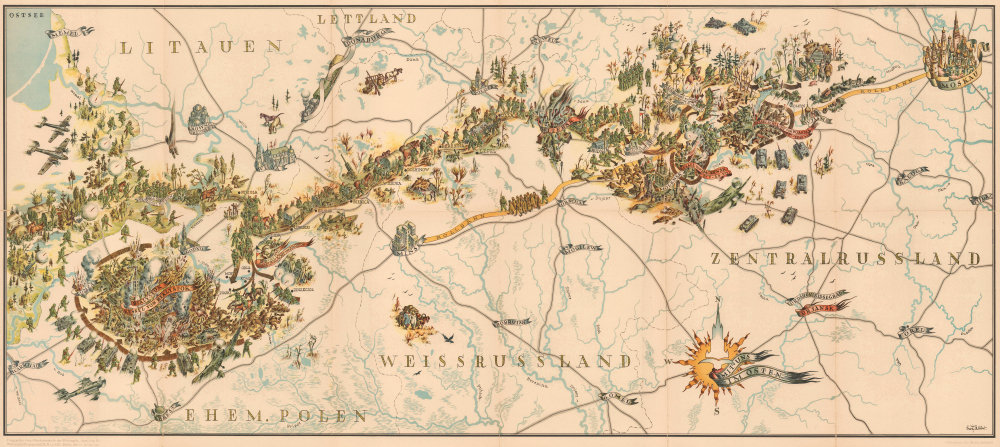
This is a 1942 Leo Faller World War II pictorial route map of the German 5th Infantry Division on the Eastern Front. The map is almost certainly a German propaganda piece meant to glamorize the wildly unpopular and, by January 1942, when it was published, failing Operation Barbarossa.
The horrors of war abound. German soldiers are illustrated slaughtering surrounded Soviet troops and marching surviving prisoners of war west. Dead Soviet soldiers appear everywhere, and the only functioning machinery is Nazi tanks, trucks, and airplanes. The only Soviet machinery that appears is two crashed airplanes northeast of Minsk.
A Closer Look
Coverage embraces from Warsaw to Moscow with the intervening cities and towns labeled; some are marked with illustrations of famous buildings, including Red Square and St. Basil's Cathedral in Moscow. The German 5th Infantry Division's movements are followed from June 22, 1941, when the Division crossed into Soviet-occupied Poland, until October 12, 1941, when it was engaged in fighting outside Vyazma, Russia. Banners identify major cities and important battles, such as the Battle of Bialystok, Smolensk, and Vyazma (Wjasma). Vitebsk (Witebsk) isn't identified as a battle but appears burning with crashed train cars nearby.The horrors of war abound. German soldiers are illustrated slaughtering surrounded Soviet troops and marching surviving prisoners of war west. Dead Soviet soldiers appear everywhere, and the only functioning machinery is Nazi tanks, trucks, and airplanes. The only Soviet machinery that appears is two crashed airplanes northeast of Minsk.
Map as Propaganda
In the bottom left corner below the border, text states that the map has been released by the Wehrmacht (Germany Army) High Command and the Wehrmacht Propaganda office in Berlin. As noted above, only glorious German victories are illustrated, and Soviet soldiers appear as hapless fools who end up surrounded, slaughtered, and taken prisoner. However, when it was published in January 1942, the German High Command knew that Operation Typhoon, better known as the Battle of Moscow, had failed to capture the Soviet capital and had, in fact, been pushed back by a Soviet counteroffensive. Nonetheless, the appearance of German dominance on the battlefield was paramount to the Nazis. This map appeared with a book proclaiming the victories of the 5th Infantry Division in the East. Intriguingly, the map does not include a single Nazi flag but one swastika, on the tail of the plane in the lower left. This leads us to wonder if Faller may have disapproved of the increasingly unpopular Nazi regime?5th German Infantry Division in World War II
Formed in October 1934, the German 5th Infantry Division was mobilized on August 25, 1939, but did not take part in the 1939 Invasion of Poland. Instead, it sat out the invasion on the Western Front and did not see combat until the 1940 Invasion of France and the Low Countries. The 5th Division remained in France on Occupation Duty until March 1941, when it was transferred to the Eastern Front to take part in Operation Barbarossa, the invasion of the Soviet Union. When Operation Barbarossa began in June 1941, the 5th Infantry fought its way east as far as the vicinity of Vyazma during Operation Typhoon (the Battle for Moscow). It was pulled off the line near the end of the year. The Division returned to the Eastern Front in March 1942 and fought near Demyansk until April. It remained in the vicinity of Staraja Russa until the end of 1943. In 1944 and 1945, the Division retreated across western Russia, Poland, and Germany, before fighting in the Battle of Berlin in April and surrendering to the Red Army at Wittenberge.Publication History and Census
This map was drawn by Leo Faller and published in 1942 in the book Mit uns Im Osten. Notations below the bottom border note that the offset printing was done by Chr. Belser in Stuttgart and that the map was 'Released by the High Command of the Wehrmacht, Department for Wehrmacht Propaganda III, H2 and IIIc Berlin, January 12 1942.' An example of the separate map is held at Cornell, part of Persuasive Maps: the PJ Mode Collection. OCLC notes a further example at the University of Illinois Urbana-Champaign. The book appears in 3 institutional collections in Germany. Both the book and the separate map appear on the market from time to time.Condition
Good. Wear and toning along original fold lines. Verso repairs to fold separations and at fold intersections.
References
Cornell University, Persuasive Maps: PJ Mode Collection 1306.01. OCLC 1350613002,