1780 Bellin Map of the Malaku Islands (Moluccas)
Moluccas-bellin-1780$250.00

Title
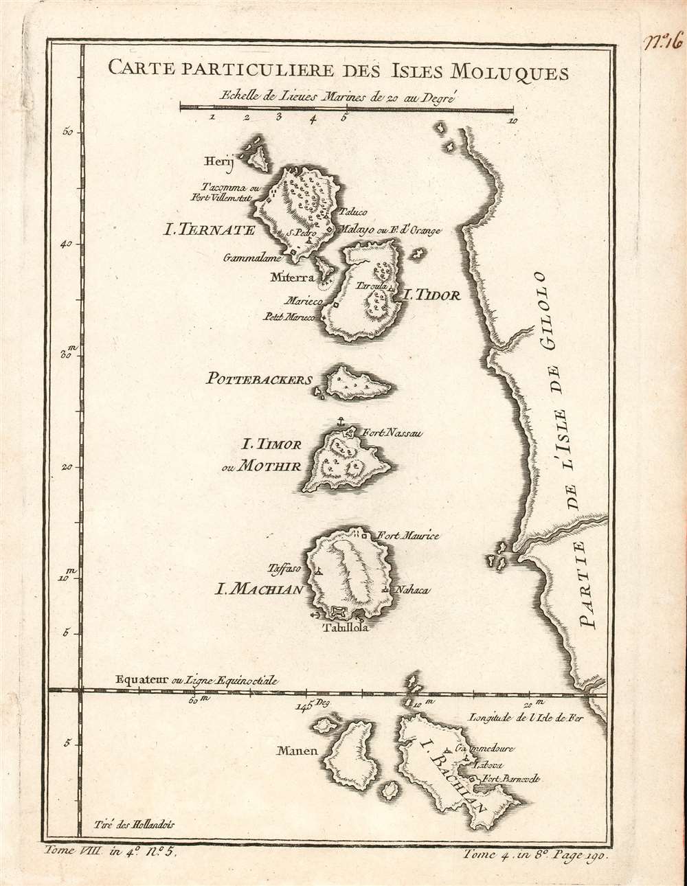
Carte Particuliere Des Isles Moluques.
1780 (undated) 8.75 x 6 in (22.225 x 15.24 cm) 1 : 620000
1780 (undated) 8.75 x 6 in (22.225 x 15.24 cm) 1 : 620000
Description
This is a beautifully engraved 1780 map of the Malaku Islands, or the Moluccas - also known as The Spice Islands. The string of islands, now part of eastern Indonesia, are shown along the west coast of the island of Halmahera, previously known as Gilolo (and so marked on the map.) Hiri Island, Ternate, Maitara, Tidore, Mare Island (Pottebackers) Moti Island (I. Timor, or Mothir) and Makian Island, are somewhat accurately delineated. Forts and settlements are noted on each island. At the southern extremity of the map, Kasiruta Island (Manen) and Bacan Island are recognizable. It is puzzling that between Makian and Bacan, the islands of Kaioa and Laluin have been omitted - but indeed, this is the case on maps of the Moluccas going back to the Age of Discovery. European explorers, arriving from a trans-Pacific voyage, seem to have coasted Halmahera/Gilolo exclusively from the north, having reached the islands north of New Guinea; this was the case with Magellan's survivors, Drake, and Le Maire. Hence Antonio Pigafetta's (c. 1491 - 1531) 1525 depiction of the Moluccas began with Ternate and ended with Machian; the 1630 Willem Blaeu (1571 - 1638) would do the same, adding Bachian as an inset. Hondius' 1633 map of the Moluccas added Bachian - in very schematic form, and too far north - as an island at the southern end of the chain. The great French geographer, Nicolas Sanson (1600 - 1667), chose this as his model. It appears that despite Bellin's having obtained a significantly better mapping of Bacan, he has been given no cause to question Sanson's placement of the island - or Sanson's naming of settlements and forts, which here is consistent both with the 17th century French geographer's map and its Dutch forebearer.
Publication History and Census
The separate map appears on the market from time to time but is somewhat neglected in institutional collections: OCLC lists perhaps twenty examples of this map in its various editions. La Harpe's Abrégé de l'histoire générale des voyages is well represented in institutions.Cartographer
Jacques-Nicolas Bellin (1703 - March 21, 1772) was one of the most important cartographers of the 18th century. With a career spanning some 50 years, Bellin is best understood as geographe de cabinet and transitional mapmaker spanning the gap between 18th and early-19th century cartographic styles. His long career as Hydrographer and Ingénieur Hydrographe at the French Dépôt des cartes et plans de la Marine resulted in hundreds of high quality nautical charts of practically everywhere in the world. A true child of the Enlightenment Era, Bellin's work focuses on function and accuracy tending in the process to be less decorative than the earlier 17th and 18th century cartographic work. Unlike many of his contemporaries, Bellin was always careful to cite his references and his scholarly corpus consists of over 1400 articles on geography prepared for Diderot's Encyclopedie. Bellin, despite his extraordinary success, may not have enjoyed his work, which is described as "long, unpleasant, and hard." In addition to numerous maps and charts published during his lifetime, many of Bellin's maps were updated (or not) and published posthumously. He was succeeded as Ingénieur Hydrographe by his student, also a prolific and influential cartographer, Rigobert Bonne. More by this mapmaker...
Source
De la Harpe, Abrégé de l'histoire générale des voyages. (Paris), 1780.
Condition
Excellent condition. Wide clean margins. Minor marginal mends not affecting printed image. Blank on verso.
References
OCLC 635284726.