This item has been sold, but you can get on the Waitlist to be notified if another example becomes available, or purchase a digital scan.
1859 Maury Map of Indian Ocean Monsoon and Trade Winds
MonsoonIndianOcean-maury-1860$2,225.00


Title
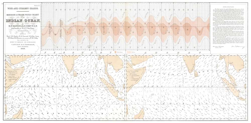
Monsoon and Trade Wind Chart of the Indian Ocean.
1860 (dated) 17.5 x 36 in (44.45 x 91.44 cm) 1 : 12500000
1860 (dated) 17.5 x 36 in (44.45 x 91.44 cm) 1 : 12500000
Description
This is Matthew Fontaine Maury's seminal 1859 map of Indian Ocean monsoon winds, a practical tool meant help navigators plot the best routes throughout the year and significantly reduce their transit times. The map represents the culmination of Maury's remarkable efforts to map the Indian Ocean's complex seasonal currents.
A Closer Look
Two maps occupy the lower half of the sheet. The map on the left details Indian Ocean monsoon winds in February, when the northeast monsoon is dominant, while the map on the right depicts the monsoon winds in August, when the southeast monsoon dominates. The chart situated in the upper half of the sheet illustrates changes in latitude of the doldrums and winter monsoons over the course of a year (separated into groups of five degrees of longitude). The explanation in the upper right corner (dated January 1860) states that the chart was compiled as the result of 16,914 separate observations.A Confederate in a Union Job
Maury's wind charts were a seminal achievement in nautical mapping, but were sidelined and often ignored by subsequent generations. Maury was born in Virginia, and when tensions broke out into the American Civil War (1861 - 1865), he returned to join the Confederacy. This act cast a pall over his relationships with his staunchly Union compatriots, particularly Alexander D. Bache, head of the U.S. Coast Survey. Bache spent much of his significant political capital sidelining Maury's work. Despite its groundbreaking reach and navigational utility, Maury's navigational works were never broadly disseminated. His work further fell out of fashion with the general rise of steamships, which made winds and current data less significant to navigation.Maury on the Wind and Current Chart Series
This chart was part of Maury's influential Wind and Current Chart Series. Maury explained the series in the introduction to the 1855 edition of his book The Physical Geography of the Sea,The primary object of the Wind and Current Charts, out of which has grown the Treatise on the Physical Geography of the Sea, was to collect the experience of every navigator as to the winds and currents of the ocean, to discuss his observations upon them, and then to present the world with the results on charts for the improvement of navigation.
Accordingly, when this object was made known, an appeal was addressed to the mariners, there was a flight up into the garrets, and a ransacking of time-honored sea-chests in all the maritime communities of the country for old log-books and journals.
It was supposed that the records therein contained as to the wind and weather, the sea and its currents, would afford information requisite for such an undertaking.
By putting down on a chart the tracks of many vessels on the same voyage but at different times, in different years, during all seasons, and by projecting along each track the winds and currents daily encountered, it was plain that the navigator hereafter, by consulting this chart, would have for a guide the results of the combined experience of all those whose tracks were thus pointed out.
Creating the Charts
After Maury became commander of the Depot of Charts and Instruments in July 1842, he was able to access the old logs of 'every voyage made by a commissioned ship in the Navy' which provided him with the necessary data to create his first charts. Not long after, Maury designed a data log and presented it to the Secretary of the Navy, who required all naval vessels to maintain these logs during every voyage. Since Maury's charts necessitated more data, he designed a much simpler chart than the one used by the Navy for use by merchantmen and convinced them to participate by offering free copies of his charts to any captain that provided data. Maury's influence, and that of the U.S. Naval Observatory and Hydrographical Office, became worldwide following the 1853 international conference on the ocean environment, where the major seafaring nations of the world adopted a log designed by Maury and 'agreed to cooperate in the collection of information for the betterment of navigation'.Publication History and Census
This map was created by Matthew Fontaine Maury in 1859 from data compiled by Lieutenants J. J. Guthrie, H. S. Newcomb, N. H. Van Zandt, Cd. C. Stout, T. T. Houston, and projected by Lieutenant R. L. May. We note five examples cataloged in OCLC which are part of the collections at Yale University, Brown University, the Library of Congress, Stanford University, and the Bayerische Staatsbibliothek.Cartographer
Matthew Fontaine Maury (January 14, 1806 - February 1, 1873) was an American astronomer, historian, oceanographer, meteorologist, cartographer, author, geologist, educator, and United States Navy officer. Maury was born in Spotsylvania County, Virginia, near Fredericksburg. He was nicknamed "Pathfinder of the Seas" and "Father of Modern Oceanography and Naval Meteorology" and later, "Scientist of the Seas," due to the publication of his extensive works in his books, especially Physical Geography of the Sea (1855), the first extensive and comprehensive book on oceanography to be published. Maury made many important new contributions to charting winds and ocean currents, including ocean lanes for passing ships at sea. In 1825 at age nineteen, Maury joined the United States Navy as a midshipman on board the frigate USS Brandywine. Almost immediately he began to study the seas and record methods of navigation. When a leg injury left him unfit for sea duty, Maury devoted his time to the study of navigation, meteorology, winds, and currents. His hard work on and love of plotting the oceans paid off when he became Superintendent of the U.S. Naval Observatory and head of the Depot of Charts and Instruments. There, Maury studied thousands of ships' logs and charts. He published the Wind and Current Chart of the North Atlantic, which showed sailors how to use the ocean's currents and winds to their advantage and drastically reduced the length of ocean voyages. Maury's uniform system of recording oceanographic data was adopted by navies and merchant marines around the world and was used to develop charts for all the major trade routes. Maury's work on ocean currents led him to advocate his theory of the Northwest Passage, as well as the hypothesis that an area in the ocean near the North Pole is occasionally free of ice. The reasoning behind this was sound: Marked harpoons found in captured whales in the Atlantic had been shot by ships in the Pacific and vice versa, and this occurred with a frequency that would have been impossible had the whales traveled around Cape Horn. With the outbreak of the Civil War, Maury, a Virginian, resigned his commission as a U.S. Navy commander and joined the Confederacy. He spent the war in the South, as well as abroad in Great Britain, acquiring ships for the Confederacy. As a result of his Confederate sympathies, Maury's work was de-emphasized in the Reconstruction era, particularly by Alexander D. Bache, head of the U.S. Coast Survey. Following the war, Maury accepted a teaching position at the Virginia Military Institute in Lexington, Virginia. He died at his home in Lexington in 1873 after completing an exhausting national lecture tour. More by this mapmaker...
Condition
Very good. Light wear along original centerfold. Closed margin tears professionally repaired on verso. Closed tear extending one-eighth of an inch into printed area from right margin professionally repaired on verso.
References
Pinsel, M.I. 'The Wind and Current Chart Series Produced by Matthew Fontaine Maury', Navigation: Journal of the Institute of Navigation, Vol. 28, No. 2, Summer 1981, pp. 123 - 137. OCLC 65215702.