This item has been sold, but you can get on the Waitlist to be notified if another example becomes available, or purchase a digital scan.
1910 Rand McNally Railroad Commission Map of Montana
MontanaRailroad-randmcnally-1910$500.00

Title
Railroad Commission Map of Montana.
1910 (dated) 40.5 x 53 in (102.87 x 134.62 cm) 1 : 760320
1910 (dated) 40.5 x 53 in (102.87 x 134.62 cm) 1 : 760320
Description
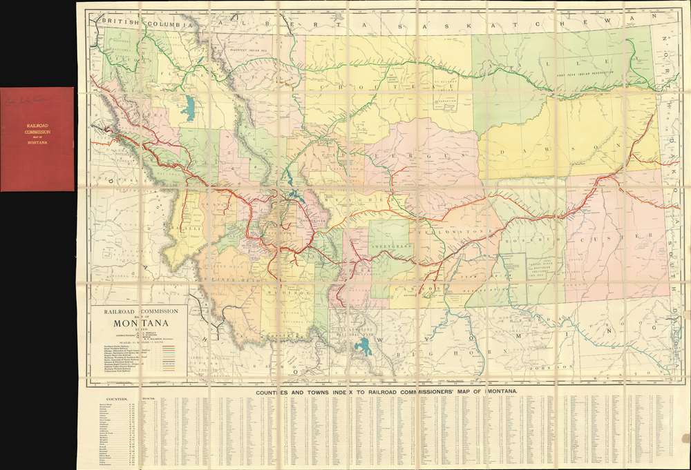
A rare 1910 large format railroad map of Montana issued for the Railroad Commission - possibly the best map of Montana to be issued in the first ten years of the 20th century. The map covers all of Montana and parts of the adjacent lands in considerable detail, naming towns, Indian Reservations, rivers, National Forests, Battlegrounds, Indian Agencies, counties, and of course, railroads. Along the bottom, roughly 1,000 towns are identified and referenced.
While in Montana, the progressives had little luck managing the entrenched mining concerns, but they were able to influence the development of the railroads. Although the most passionate progressives argued for a full state takeover of all Montana railroads, the state legislature ultimately found a middle ground, establishing the Montana Railroad Commission in 1907. This map's first issue, in 1908, and subsequent 2nd issue in 1910 (present example), correspond to the Commission's need for detailed cartography to plan and implement its regulatory mission. The Commission successfully exercised its powers on a number of fronts, leading to a more people-focused railroad system than common in other parts of the country. In 1913, the authority of the Montana Railroad Commission was expanded dramatically, and it was renamed the Montana Public Service Commission.
Montana Railroad Commission and the Progressive Movement
In the early years of the 20th century, Montana went through a boom of development and growth - largely coinciding with the arrival of the railroads and the development of large-scale mining around Butte and elsewhere. While these industries were catalysts for the economic development of the region, they were largely controlled by powerful business magnates and corporations based in large centers farther east. This gave rise to grass-roots rural-based progressive-populist movements in Montana, Wyoming, and Colorado. These movements argued for the local empowerment of the largely rural states and canvassed to limit the growing influence of national big-business concerns.While in Montana, the progressives had little luck managing the entrenched mining concerns, but they were able to influence the development of the railroads. Although the most passionate progressives argued for a full state takeover of all Montana railroads, the state legislature ultimately found a middle ground, establishing the Montana Railroad Commission in 1907. This map's first issue, in 1908, and subsequent 2nd issue in 1910 (present example), correspond to the Commission's need for detailed cartography to plan and implement its regulatory mission. The Commission successfully exercised its powers on a number of fronts, leading to a more people-focused railroad system than common in other parts of the country. In 1913, the authority of the Montana Railroad Commission was expanded dramatically, and it was renamed the Montana Public Service Commission.
Railroads On the Map
The railroads identified are:- Northern Pacific Railway (Red)
- Great Northern Railway (Green)
- Chicago, Milwaukee and Puget Sound Railway (Orange)
- Chicago, Burlington and Quincy Railroad (Teal)
- Oregon Short Line Railroad (Purple)
- Montana, Wyoming and Southern Railroad (Dark Green)
- Butte, Anaconda and Pacific Railway (Brown)
- Gilmore and Pittsburg Railroad (Black)
- Montana Rapid Transit Company (Dashes Blue)
- Gallatin Valley Electric Railway (Blue)
- Montana Western Railway (Yellow)
- Yellowstone Park Railway (Grey)
Publication History and Census
This map was published in Chicago by the Rand McNally Company for the Montana Railroad Commission. The earliest publication of this map we have been able to trace in 1908. Editions followed in 1910 (present example), 1915, and 1917. This map has provenance connecting it to Captain J. L. Tucker, an influential in the early development of the Montana National Guard. Today this map is scarce on the market.Cartographer
Rand, McNally and Co. (fl. 1856 - present) is an American publisher of maps, atlases and globes. The company was founded in 1856 when William H. Rand, a native of Quincy, Massachusetts, opened a print shop in Chicago. Rand hired the recent Irish immigrant Andrew McNally to assist in the shop giving him a wage of 9 USD per week. The duo landed several important contracts, including the Tribune's (later renamed the Chicago Tribune) printing operation. In 1872, Rand McNally produced its first map, a railroad guide, using a new cost effective printing technique known as wax process engraving. As Chicago developed as a railway hub, the Rand firm, now incorporated as Rand McNally, began producing a wide array of railroad maps and guides. Over time, the firm expanded into atlases, globes, educational material, and general literature. By embracing the wax engraving process, Rand McNally was able to dominate the map and atlas market, pushing more traditional American lithographic publishers like Colton, Johnson, and Mitchell out of business. Eventually Rand McNally opened an annex office in New York City headed by Caleb S. Hammond, whose name is today synonymous with maps and atlases, and who later started his own map company, C. S. Hammond & Co. Both firms remain in business. More by this mapmaker...
Condition
Very good. Some toning on original fold lines. Folds into original binder.
References
OCLC 11446509.