This item has been sold, but you can get on the Waitlist to be notified if another example becomes available, or purchase a digital scan.
1881 Eldridge Nautical Chart / Map of the East Coast of the United States
MontaukPtStAugustine-eldridge-1881$750.00


Title
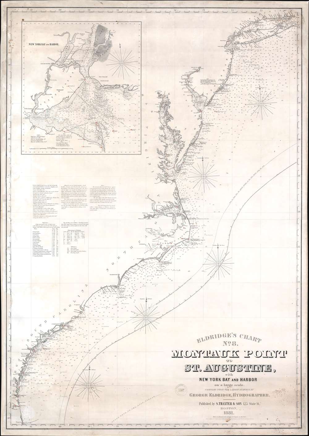
Eldridge's Chart No. 8. Montauk Point to St. Augustine, with New York Bay and Harbor on a Large Scale.
1881 (dated) 51.25 x 36.5 in (130.175 x 92.71 cm) 1 : 1050000
1881 (dated) 51.25 x 36.5 in (130.175 x 92.71 cm) 1 : 1050000
Description
This is an 1881 George W. Eldridge blueback nautical chart or maritime map of the east coast of the United States covering from Long Island Sound to St. Augustine, Florida. The chart provides a nautical overview of the eastern seaboard, with countless depth soundings and coastal navigation lights marked in manuscript orange. The Chesapeake Bay especially offers stunning detail - reflecting nearly 50 years of constant meticulous hydrographic work. Coastal islands along New Jersey, Maryland, and the Carolinas, are illustrated in detail as well. The Gulf Stream curves its way to the northeast through the Atlantic. An inset in the upper left corner details New York Bay and Harbor. Depth soundings are indicated throughout the bay and harbor and up the Hudson and East Rivers. New York, Brooklyn, Fort Hamilton, New Utrecht, Gravesend, Jersey City, Hoboken, and Newark are all labeled.
Blueback Charts
Blueback nautical charts began appearing in London in the late 18th century. Bluebacks, as they came to be called, were privately published large format nautical charts known for their distinctive blue paper backing. The backing, a commonly available blue manila paper traditionally used by publishers to wrap unbound pamphlets, was adopted as a practical way to reinforce the low-quality paper used by private chart publishers in an effort to cut costs. That being said, not all blueback charts are literally backed with blue paper. The earliest known blueback charts include a 1760 chart issued by Mount and Page, and a 1787 chart issued by Robert Sayer. The tradition took off in the early 19th century, when British publishers like John Hamilton Moore, Robert Blachford, James Imray, William Heather, John William Norie, Charles Wilson, David Steel, R. H. Laurie, and John Hobbs, among others, rose to dominate the chart trade. Bluebacks became so popular that the convention was embraced by chartmakers outside of England, including Americans Edmund March Blunt and George Eldridge, as well as Scandinavian, French, German, Russian, and Spanish chartmakers. Blueback charts remained popular until the late 19th century, when government subsidized organizations like the British Admiralty Hydrographic Office and the United States Coast Survey, began issuing their own superior charts on high quality paper that did not require reinforcement.Publication History and Census
This map was created by George W. Eldridge and published by S. Thaxter and Son in 1881. We have located editions of this map dating as early as 1874 and as late as 1884. This is the only discoverable example of the present 1881 edition.CartographerS
George Eldridge (November 27, 1821 - August 23, 1900) and his son George Washington Eldridge (1845 - 1914) were American makers of nautical charts and Pilot Books active in the late 19th century. George Eldridge was a Cape Cod fisherman known locally as an excellent ship's pilot. While recuperating from an injury in 1851, Eldridge drew his first nautical chart. The chart proved popular, and its success led Eldridge to pursue a career in hydrography - the science of mapping the sea with a special focus on navigation. Eldridge produced numerous subsequent maps and is credited with issuing some of the earliest accurate nautical charts of the American Atlantic coast. In time George Eldridge passed his thriving business on to his son, George Washington Eldridge, who continued to produce beautiful and practical maritime charts until 1924.Though most of Eldridge's charts were loosely based on U.S. Coast Survey work, they proved popular with navigators. The Eldridges possessed a talent, shared by both father and son, for distilling the often convoluted Coast Survey maps into practical nautical charts for the working mariner. From 1875, in addition to large format independently issued nautical charts, Eldridge also issued annual editions of Eldridge's Tide and Pilot Book and The Book of Harbor Charts. The Eldridge offices were located at 103 State St. Boston, Massachusetts. After the deaths of George and George Washington Eldridge, the firm passed into the hands of the latter's widow Sydna, and son-in-law, Wilfrid O. Wight. Wight's son and subsequent generations have continued to publish the Eldridge Tide and Pilot Book down to the present. More by this mapmaker...
Samuel Thaxter and Son (fl. 1792 - 1916). Samuel Thaxter (1769 - 1842) is the founder of a Boston dynasty of manufacturers of mathematical instruments and nautical charts. He founded the firm in 1792 and is first referenced in the 1796 Boston Directory. Around 1822 he incorporated his son, Joseph H. Thaxter (1801 - 1835), into the business renaming it 'Samuel Thaxter and Son'. The firm would retain this name for the remainder of its existence. This successful business was subsequently passed to Joseph H. Thaxter's son, Samuel Thaxter Cushing (1821 - 1882), in 1843. It was Thaxter Cushing who developed the firm's publishing arm, partnering with the Boston nautical chart maker George Eldridge. They are best known for 13 large format blueback charts focusing on the east cost of the United States published in the second half of the 19th century. They also published numerous smaller maps and pilot books. After Thaxter Cushing died the firm was taken over by his widow, Abby C. Cushing, who managed it until 1905. It was subsequently managed by Herbert Risteen Starratt and continued to be registered in the Boston Directory until about 1916. Learn More...
Condition
Good. Full professional restoration. Mounted on linen. Exhibits areas of toning, dampstaining, foxing, and light soiling. Exhibits some reinstated areas, including in the upper and lower right corners. This is a blueback, but the back is not actually blue paper, but linen.