This item has been sold, but you can get on the Waitlist to be notified if another example becomes available, or purchase a digital scan.
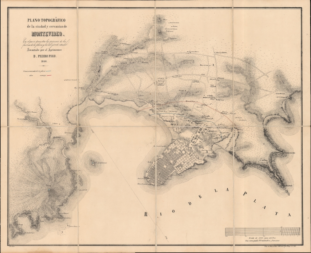
1846 Pedro Pico Plan of Montevideo, Uruguay (During the Great Siege)
Montevideo-pico-1846$1,200.00


Title
Plano Topográfico de la ciudad y cercanias de Montevideo.
1846 (dated) 16 x 19.75 in (40.64 x 50.165 cm) 1 : 28000
1846 (dated) 16 x 19.75 in (40.64 x 50.165 cm) 1 : 28000
Description
This is an elegant and rare 1846 Pedro Pico map of Montevideo, Uruguay. It was published in Montevideo during the Great Siege of Montevideo during the Uruguayan Civil War (1839 - 1851).
A Closer Look
This map was drawn by Argentine surveyor Pedro Pico, who was among Montevideo's defenders during the siege. Red and blue manuscript marks the lines of the besieged and the besiegers, while the positions of artillery batteries and specific military units are printed. It is likely that Pico's work began prior to the siege, and that his primary focus - as a surveyor to the Department of Mines - was on the developing salt industry. Seven salt pans are noted. The plan also notes a cervezeria, possibly the first recorded brewery in Uruguay.The Great Siege of Montevideo
The newly independent nation of Uruguay was wracked by civil war from 1830 to 1851. Opposing presidents, Fructuoso Rivera and Manuel Oribe, formed opposing political parties: the Colorados and the Nationals, respectively. Oribe's Nationals, wearing white armbands, came to be known as Blancos. Rivera's, with red armbands, and were dubbed Colorados. Following the defeat of the Colorados at the battle of Arroyo Grande, the Blancos moved to swiftly take Montevideo. The Colorado defense of the city, with substantial support from a large community of foreign exiles (including the famous Italian revolutionary Giuseppe Maria Garibaldi), and a contingent of 5,000 free slaves, forced a protracted siege, defending the city for 9 years. The siege ended when the British navy opened a supply line for Montevideo, effectively breaking the siege.Publication History and Census
This lithograph was prepared and published in 1846 in Montevideo by Litografia de Mege y Lebas (Calle del 25 de Mayo, No. 233). The present map is the first and scarcer of two known editions. A second edition, published in Paris by Chaix, is easily distinguished from the first as battle lines are printed, and the composition of the scales differs. There are only four examples of the second edition of this map noted in institutional collections. Of this first edition, printed in Montevideo, we note only one other example, located at the University of Wisconsin.Cartographer
Pedro Pico (1810 - 1886) was an Argentine surveyor. Born in Buenos Aires, he was educated as an engineer in England. Returning to America, he became a surveyor for Uruguay. By 1837, he was employed in that capacity by the Department of Mines; some manuscripts of his have survived from that period. With the advent of the Uruguayan Civil War, he moved to Montevideo and joined the forces holding the city against Rosas. He produced a plan of the city in 1845 during the course of the siege, marking the positions of the opposing forces. In its first edition, it is one of the earliest maps printed in Uruguay. Following the war, Pico returned home to Buenos Aires where he taught classes at the University and joined the Topographic Department. He also produced geographical map of the province of Entre Ríos, during the period in which it was governed by General Urquiza. He retired to Rivadavia in Argentina, and died in 1886. More by this mapmaker...
Condition
Excellent. Dissected and mounted on linen for folding, as issued. Original marbled paper covers, worn.
References
OCLC 56124487.