This item has been sold, but you can get on the Waitlist to be notified if another example becomes available, or purchase a digital scan.
1927 Loret de Mola Pictorial Map of Havana, Cuba
MonumentalHavana-mola-1927$225.00

Title
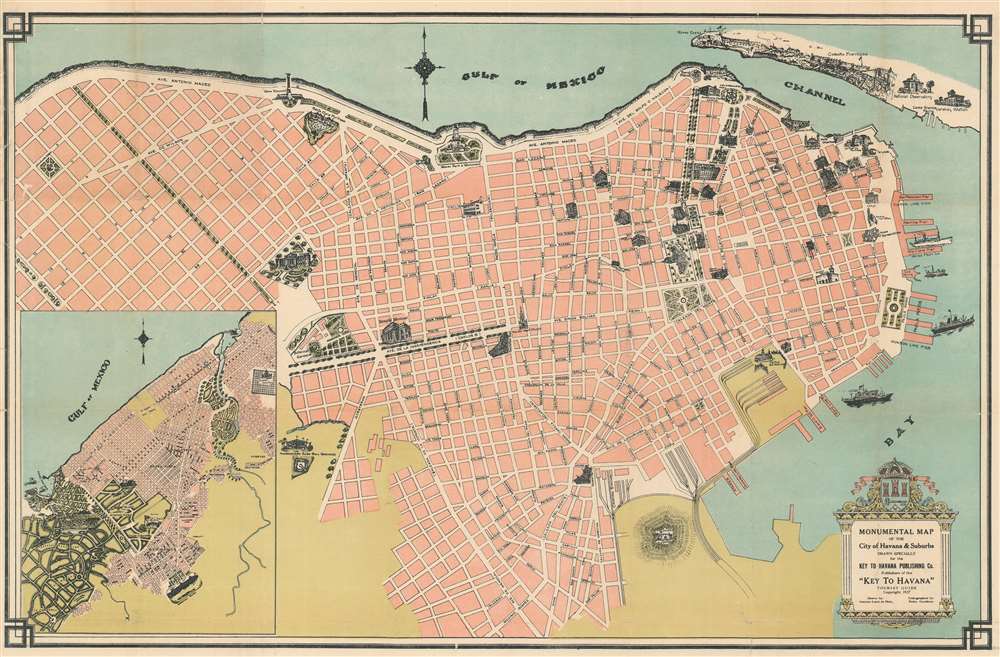
Monumental Map of the City of Havana and Suburbs. Drawn Specifically for the Key to Havana Publishing Co. Publishers of the 'Key to Havana' Tourist Guide.
1927 (dated) 17 x 26 in (43.18 x 66.04 cm)
1927 (dated) 17 x 26 in (43.18 x 66.04 cm)
Description
This is a 1927 Antonio Loret de Mola pictorial map of Havana, Cuba. The map depicts the city from Villalón Park and the Avenida Paseo to Havana Harbor and from the La Cabaña Fortress and the Entrance Channel to the Castillo de Atarés. Beautifully illustrated, numerous sites around the city are illustrated in profile, including the several hotels, the Congress building, the House of Representatives, the National Library, the National University, and the national theatre. Monuments throughout the city are also shown, including the Maine Monument, which was erected in 1925 in remembrance of the victims of the USS Maine, and the monument to Antonio Maceo Grajales, the second-in-command of the Cuban Army of Independence. Special attention is paid to Havana's fortresses, such as the La Cabaña (Fortaleza de San Carlos de la Cabaña), the third largest fortress in the Americas, Morro Castle (Castillo de Los Tres Reyes del Morro), La Punta Fortress (Castillo San Salvador de la Punta), and the Atares Fortress (Castillo de Atarés). City parks, illustrated in green, are scattered all around the city. An inset map situated in the lower left corner, depicts from the Marianao Beach to the Columbus Cemetery and from the Gulf of Mexico to Oriental Park.
Publication History and Census
This map was drawn by Antonio Loret de Mola and lithographed by Pedro Gutiérrez in 1927. We have been able to locate examples in five institutional collection at Harvard, Dartmouth, the University of Chicago, the University of Kansas, and the Newberry Library in Chicago. This map is very scarce on the market, as we have been able to trace only one other example entering the private market.Cartographer
Anthony Loret de Mola (September 20, 1903 - January 7, 1960) was a Cuban-American artist, draftsman, and mapmaker. Born in Vera Cruz, Mexico, De Mola arrived in the United States in Key West on April 5, 1929, having most recently lived in Havana, where he created maps for the Key to Havana Tourist Guide. By 1942, De Mola was working as a mapmaker for the Hagstrom Company in New York City. De Mola lived at 247 Audubon Avenue, from at least 1942 until his death in 1960. His wife Suzana (April 10, 1910 - 1981) was of Armenian descent and was born at Constantinople, Turkey. They married on July 21, 1934 and had no children. More by this mapmaker...
Condition
Very good. Backed on archival tissue for stability. Blank on verso.
References
OCLC 21965510.