This item has been sold, but you can get on the Waitlist to be notified if another example becomes available, or purchase a digital scan.
1904 U.S. Army Map of Monument Park, National Mall, Washington D.C.
MonumentPark-corpsengineers-1904$475.00


Title
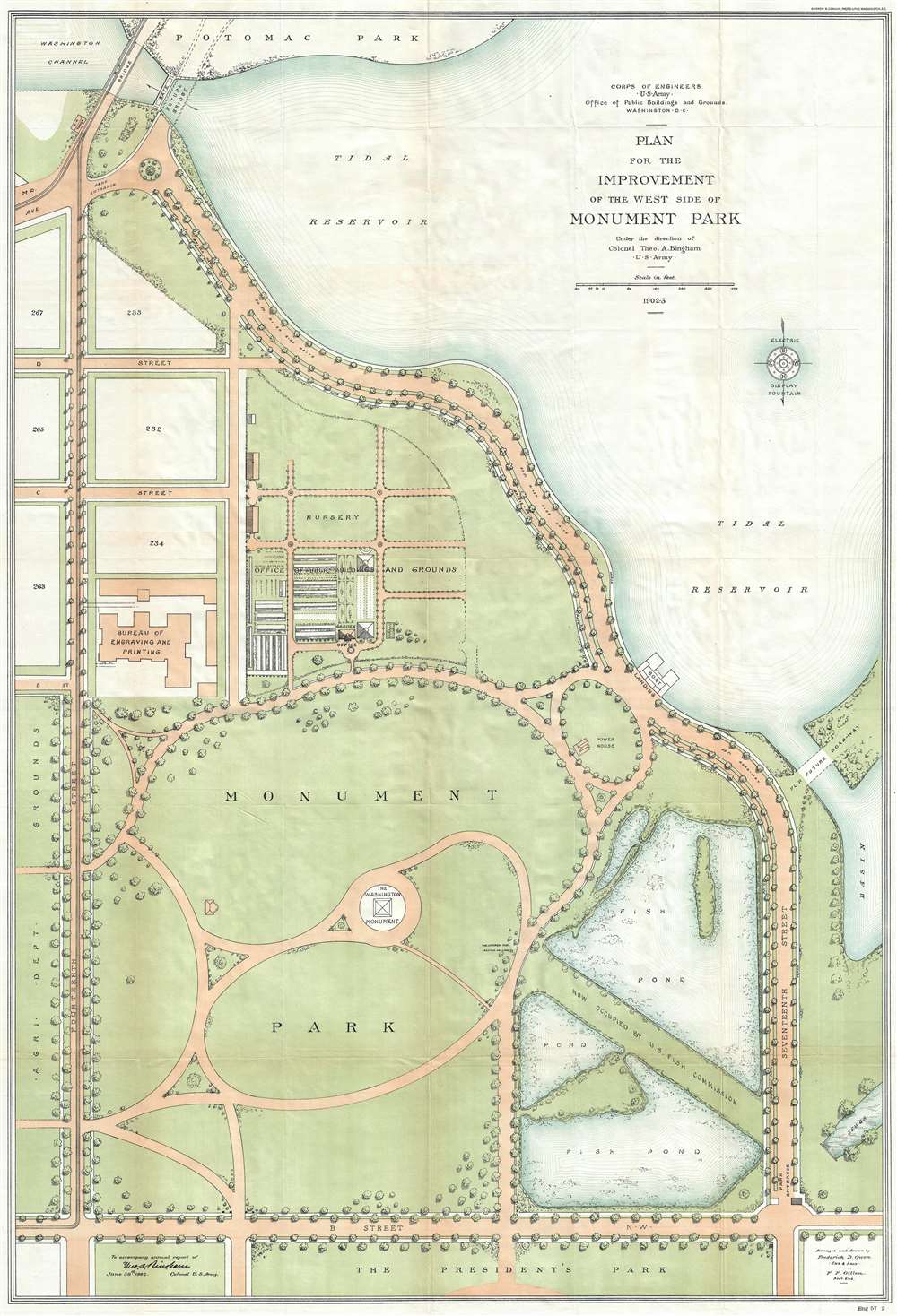
Plan for the Improvement of the West Side of Monument Park.
1904 (dated) 40 x 27.5 in (101.6 x 69.85 cm) 1 : 1200
1904 (dated) 40 x 27.5 in (101.6 x 69.85 cm) 1 : 1200
Description
This is a 1902-04 U.S. Army Corps of Engineers map of Monument Park, the National Mall, Washington D.C. This map was issued to address draining issues of drainage - note the large fishponds in the lower right. Centered on the Washington Monument and oriented to the south, with north at the bottom, the map depicts from the President's Park at the bottom to the tidal reservoir, the Maryland Avenue Bridge and Potomac Park at the top, and from Fourteenth Street to Seventeenth Street and the tidal basin on the right. Above Memorial Park and the Washington Monument, B, C, and D Streets are depicted as well as several city blocks. The Bureau of Engraving and Printing is identified, as well as the Nursery of the Office of Public Buildings and Grounds. To the right of Monument Park, two fishponds are illustrated, which, per the map, were part of the U.S. Fish Commission. To the left of Monument Park, across Fourteenth Street, lies the grounds of the Agriculture Department.
Publication History and Census
This map was prepared under the supervision of Colonel Theo. A. Bingham of the U.S. Army, arranged and drawn by Frederick D. Owen, the Engineer and Architect of the project, and F. F. Gillen, the Assistant Engineer. The map was lithographed by Andrew B. Graham of Washington, D.C. It was prepared to accompany the report of Colonel Bingham, printed around 1804.CartographerS
Army Corps of Topographical Engineers (fl.1838 - 1863) refers to the an elite branch of the U.S. Army created on July 4, 1838 to perform civil mapping and survey work throughout the United States. The origins of the Corps of Topographical Engineers can be traced back to the American Revolutionary War, where General George Washington recognized the need for accurate surveys pursuant to military action. Shortly following the war, in 1779, a civilian engineering corps was created by act of Congress. Identified in 1802 by Thomas Jefferson, the "Corps of Engineers," which was based at West Point, the group participated in the War of 1812 and in later in the fortification of New Orleans. It was not until 1838, however, that a separate group of "Topographical Engineers" was formally recognized. This elite group, consisting only of officers, most of whom were trained in surveying and engineering by the esteemed Andrew Ellicott at West Point, never numbered more than 36 individuals - the best and brightest. This small but determined group played a central role in the mapping and exploration of the American West. Few branches of the military can boast such a distinguished alumni. Their names resonate throughout the map of the west and include John Charles Fremont, Zebulon Pike, George Meade, Kemble Warren, William Amiel Weeks, A. B. Gray, Randolph B. Marcy, James H. Simpson, Howard Stansbury, John W. Gunnison, William Ludlow, and Robert S. Williamson. The onset of the American Civil War brought an abrupt end to the surveying activity of the Topographical Engineers. Many of the most prominent engineers went on to distinguished military careers on both sides of the War Between the States. The Army Corps of Topographical Engineers itself was folded into the Corps of Engineers on March 31, 1863. Though the Army Corps of Engineers continues to do military and civil survey work to this day, the elite club of adventures that formed the Topographical Engineers were no more. More by this mapmaker...
Andrew B. Graham (1845 - September 9, 1909) was an American lithographer active in Washington, D.C. in late 19th and early 20th century. Graham was born in Washington D.C., the son of a lithographer and engraver. After college, he joined the U.S. Coast Survey, where he was a draftsman until 1889. He retired from the Coast Survey to take over management of his father's lithography firm. The firm, Andrew B. Graham Company, was one of several that thrived on lucrative government publication contracts. Graham died of 'brain fever' in his Washington D. C. residence on September 9 of 1909. Some of his work was republished posthumously until about 1917, and his firm was active until at least the early 1920s. Learn More...
Frederick D. Owen (1871 - January 28, 1931) was an American cartographer, engineer, and architect active in Washington D.C. in the late 19th and early 20th centuries. Owen was born in Connecticut, Owen was a civilian contractor with the U.S. Bureau of Topographical Engineers. He worked with the First Lady Caroline Harrison (1832 - 1892), wife of President Benjamin Harrison, to plan an ambitious expansion of the White House, but it was never realized. Seven of his maps are located in the Library of Congress. He created the maps that hung in the ‘War Room’ at the White House during the Spanish-American War (‘Frank Leslie’s Popular Monthly’, Vol. L, No. 2, 113.). Later, Owen worked for the Washington D.C. Parks department. Learn More...
Condition
Very good. Wear along original fold lines. Blank on verso.
References
OCLC 13335909.