
1938 Getmanski / Intourist Pictorial Map of Moscow, Soviet Union

Moscow / Moscow Pictorial Street-Map.
Tourism amid Stalin's Great Terror.
- Digital Map Information
- Suitable for large format printing
- Full resolution TIFF file
- ICC color profile embedded
- Delivered instantly via download link
Tourism amid Stalin's Great Terror.
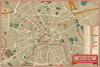
This is Michael (Mikhail) Getmanski's 1938 pictorial map of Moscow, prepared for the Soviet tourist agency, Intourist. Produced at the height of Stalin's Great Terror, it gives no hint of the turmoil underway, instead presenting the Soviet capital as a placid wonderland of beautiful gardens, wide boulevards, and monumental architecture. Intourist publications, particularly their maps, are highly collectibe and admired for their high-quality printing and Soviet Art Deco graphics.A Closer Look
Moscow is presented with the 'Garden Ring' surrounding the historic core of the city, which is clearly evident. A wide range of government and party buildings, parks, rail stations, museums, theaters, and other landmarks are illustrated and labeled or numbered and listed in an index on the right. A grid surrounds the map to provide coordinates for finding locations in the index. A glossary appears below the title to translate common Russian words used in street and place names. The map was intended for international tourists, many of them being Western intellectuals and labor leaders enamored with or at least curious about the Soviet Union and, at this point, dismissive of the stories of Bolshevik repression and Stalin's totalitarianism.Each of these sites has a story to tell of the early Soviet Union and the Stalinist era, perhaps none more than the House on the Embankment ('Government House and New Theater'). This huge complex had been constructed during the era of Stalin's First Five-Year Plan (1928 - 1932) to house the Party elite, given its close proximity to the Kremlin. In addition to apartments, it included a wide range of services, including a supermarket, a theater, a movie theater, restaurants, and more. However, many of its residents were executed or sent to the Gulag during the Great Purge underway when this map was published. In the early 1990s, the building was designated as a museum.
Historical Context
It is notable that churches and monasteries are labeled even though these were non-operational at the time, with many having been closed or converted to secular use, such as warehouses or, in the most extreme cases, anti-religious museums, as was the case with the Strastnoi Monastery, seen towards the top-left here. Ironically, just as Stalin's Great Terror was unleashed in 1937-38, a somewhat more moderate policy towards religious structures was adopted, in that several important churches and monasteries were spared from planned demolition. Nevertheless, dozens of other churches and monasteries throughout Moscow were destroyed in the early Soviet period, including two in 1938 (not seen here), the Church of Cosmas and Damian and the Church of St. Nicholas the Wonderworker.The destruction of religious sites was only one piece of a much larger project to remake Moscow as the national and even global capital of socialism. Although considerable demolition and construction had taken place beforehand, the culmination of this vision was laid out in the 1935 General Plan for the Reconstruction of Moscow, which sought to replace the city's 'chaotic,' medieval layout with a rationalized grid of gargantuan proportions. To make way for new Soviet monumental architecture and wide, parade-ready avenues like Gorky Street (now Tverskaya), centuries of history were systematically erased, and iconic landmarks were dynamited (including the Cathedral of Christ the Savior and the Sukharev Tower). The crown jewel of this architectural overhaul was intended to be the Palace of the Soviets, a building designed to be the tallest in the world, topped with a 100-meter statue of Vladimir Lenin. It was meant to be built on the foundation of the Cathedral of Christ the Savior, which was demolished in 1931. The site is not mentioned here (it was across the river from the House on the Embankment); construction was already underway, but later halted due to the Nazi invasion of the Soviet Union. The Palace was never completed, and the site instead became a massive swimming pool until the fall of the Soviet Union, after which the cathedral was reconstructed.
Publication History and Census
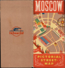
This map was prepared by artist Michael Getmanski (Михаил Гетманский) and published by Intourist in 1938. A French and a German edition were also prepared ('Moscou, carte illustrée des rues de Moscou' and 'Moskaum Bilderkarte der Moskauer Strassen,' respectively). In any language, the map is scarce today, with institutional holdings of the English-language map at the Library of Congress, Harvard University, the British Library, University College London, the Tate Library, the University of Otago, and the David Rumsey Historical Map Collection.Cartographer
Mikhail Panteleymonovich Getmanski (Михаил Пантелеймонович Гетманский ; October 13, 1900 - 1969) was a Russian-Soviet graphic artist and illustrator. He was born in Taganrog on the Sea of Azov. The background to his training is unknown, but he produced works for several important early Soviet-era publishing houses, including Krug (Круг), Gosizdat (Госиздат), OGIZ (ОГИЗ), and Detgiz (Детгиз). Getmanski also became the staff artist for the magazine Circus and Variety Arts (цирк и эстрада), originally just Circus (цирк), designing its covers and interior illustrations. He also illustrated many fiction books over the course of his career, including translations of Arthur Conan Doyle's The Maracot Deep and H.G. Wells' short story 'The New Accelerator.' He is best known in cartographic terms for preparing a 1938 pictorial tourist map of Moscow for Intourist. Getmanski's entire body of work is notable for combining elements of Art Deco design with Russian and Soviet norms, contributing to a distinctly Soviet aesthetic of the 1920s - 1940s. Further Details...
Condition
Very good. Slight wear and verso stabilization at a few old fold intersection points. Attached to original paper binder.
References
Rumsey 8745.002. OCLC 21044057, 1170603828.