
1962 Intourist Pictorial Tourist Map of Moscow

Moscow.
Touring Moscow at the Height of the Cold War.
Touring Moscow at the Height of the Cold War.
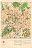
This is a c. 1962 pictorial tourist map of Moscow, the capital of the Soviet Union and center of international Communism. It was issued while the city was undergoing a widespread modernization effort and at the height of the Cold War, when the U.S. and U.S.S.R. nearly fought a nuclear war due to the Cuban Missile Crisis.A Closer Look
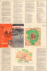
The map covers the main part of central Moscow, expanding beyond its historic core in the immediate vicinity of the Kremlin (the focus of an inset at the bottom-right) to highlight newer Soviet-era attractions. These include monumental buildings of the late Stalinist and early post-Stalin period such as the Hotel Ukrainia, the Lenin (now Luzhniki) Stadium, and the new campus of Moscow State University in Sparrow Hills in the city's southwest. Among the students at the new campus was Mikhail Gorbachov (1931 - 2022), who met his wife, fellow student Raisa Titarenko (1932 - 1999), there. A legend at the top-right notes the location of Metro stations, restaurants, theaters, cinema houses, gas stations, and hotels. The verso includes a map of the Metro system, a map of the wider Moscow metro area, and text about major hotels, museums, exhibition halls, and other helpful information for travelers. Though travel to the Soviet Union from leading English-speaking capitalist countries was difficult at this time, it was not impossible, especially for those well-disposed towards the U.S.S.R.Historical Context
Moscow grew substantially and changed dramatically in the Stalin and early Khrushchev eras, including an impressive and immaculately clean metro system. But the city faced a severe housing shortage in the immediate postwar years. After considering various possibilities, Soviet architects and urban planners decided on pre-fabricated concrete-paneled apartment buildings that came to be known as khrushchevka, after the Soviet leader who was chief of the Party in Moscow before becoming First Secretary of the Communist Party in 1953. Meant to be a temporary solution to the housing shortage until the fruits of Communism delivered plentiful housing for all, the buildings proliferated in the 1950s and 1960s across the Soviet Union and became a fixture of Soviet life. Eventually, most of Moscow's population would be housed in khrushchevka, though in recent years many have been demolished and replaced with more modern structures through the ambitious Moscow Urban Renewal Initiative. The growing population and relative improvement in living standards in the 1950s also led to traffic jams throughout the city, prompting the construction of the Moscow Ring Road (MKAD), beyond the scope of the recto map but marked on the verso as 'Moscow By-Pass Highway,' completed the same year the map was issued.More broadly, though it was likely prepared before the Cuban Missile Crisis, this map nevertheless overlaps with a period of heightened tension in the Cold War. The Soviets had initially hoped to have a better relationship with the incoming President Kennedy than with the outgoing President Eisenhower, but outside events and missteps by both sides instead brought the world to the brink of nuclear war. Khrushchev's attempt to solve the 'Berlin Problem' through bullying and threats instead provoked a strong American reaction and led to the 'solution' of the Berlin Wall, which began construction in August 1961. That year also saw the Soviets launch the first man into space, demonstrating their lead in the Space Race, and the detonation of the Tsar Bomba, the largest nuclear device ever exploded. The bungled American plot to overthrow Castro's regime in Cuba in the Bay of Pigs invasion was an international embarrassment for the young Kennedy Administration and prompted greater Soviet involvement in Cuba. But here too, Khrushchev overplayed his hand, despite having a legitimate gripe about American missiles in Turkey. By secretly trying to station nuclear missiles in Cuba, Khrushchev nearly brought about a nuclear war, a mistake that led to his downfall in 1964.
Publication History and Census
This map was prepared and published by Intourist, the official tourist agency of the Soviet Union. It is undated but the date of 1962 can be inferred from the caption below the Metro map on the verso. The map is held by about fifteen institutions in the OCLC and occasionally appears on the market.Cartographer
Intourist (April 12, 1929 - Present) was the official tourism agency in the Soviet Union and was responsible for welcoming all foreign tourists to the U.S.S.R. and providing them with guides. Intourist was founded by the People's Commissariat of Commerce, the People's Commissariat of Railways, and the Sovtorgflot merchant fleet, and its name is a contraction of inostrannyj turist (foreign tourists). Its first foreign office opened in London about 1930, and locations in Amsterdam, Berlin, and New York soon followed. Intourist 'owned' hotels and other important tourism related businesses throughout the Soviet Union, but, since they were owned by the Soviet government, Intourist itself never truly owned anything. Privatized in 1992, a majority share (50.1%) was owned by the British Thomas Cook Group from 2011 until the group collapsed in September 2019. It was then acquired by Anex Tours, a company based in Turkey, in November of that year. Further Details...
Condition
Very good. Light wear along original fold lines. Small areas of loss at fold intersections.
References
Rumsey 15743.002. OCLC 31147711.