
This item below is out of stock, but another example (left) is available. To view the available item, click "Details."
Details
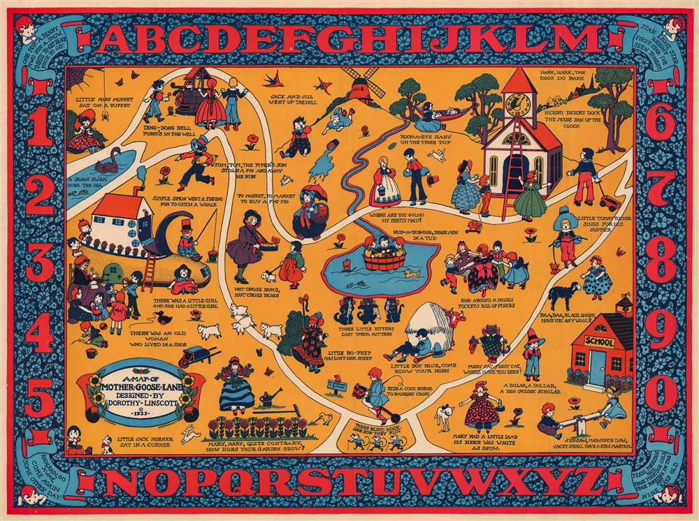
1933 Linscott Pictorial Map of Mother Goose Land
$500.00
1933 Linscott Pictorial Map of Mother Goose Land
MotherGooseLand-linscott-1933$250.00

Title
A Map of Mother Goose Land.
1933 (dated) 15.5 x 21 in (39.37 x 53.34 cm)
1933 (dated) 15.5 x 21 in (39.37 x 53.34 cm)
Description
This is a 1933 Dorothy Linscott pictorial map of Mother Goose Land. Populated by characters from Mother Goose nursery rhymes, Little Jack Horner, Jack and Jill, the Old Woman Who Lived in a Shoe, Little Miss Muffet, and Mary and her Little Lamb all make appearances. Other rhymes that are referenced include 'Ring Around a Rosies', 'Hickory Dickory Dock', and 'Rock-a-bye Baby'. The ABCs and the numbers up to ten occupy the pictorial border and four more rhymes appear in the corners.
Publication History and Census
This map was created by Dorothy Linscott and published in 1933. This map does not appear in OCLC and we are aware of only one other cataloged example in private hands.Cartographer
Dorothy Linscott Clarke (April 29, 1903 - May 17, 1992) was an American artist known for her pictorial maps - as such she was one of a series of pioneering women cartographers active in the pictorial map genre. She lived in Hampton, Maine, with her husband, the advertising consultant Charles C. Clarke (???? - 1969). Her earliest known work is a 1930 pictorial map of Noah's Ark, followed by the 1939 Historical Picture Map of Vermont, which is rare enough that we have never seen an example. She later lived in Sudbury or Shrewsbury, Massachusetts. She created pictorial maps of Vermont and Worcester County, Massachusetts, along with fantasy maps of subjects including Mother Goose. More by this mapmaker...
Condition
Very good. Closed margin tears professionally repaired on verso. Closed tears extending one-half (.5) inch into printed area from right margin professionally repaired on verso.