1898 Buell Map of the Mother Lode, Stockton, California
MotherLodeStockton-buell-1898$1,000.00

Title
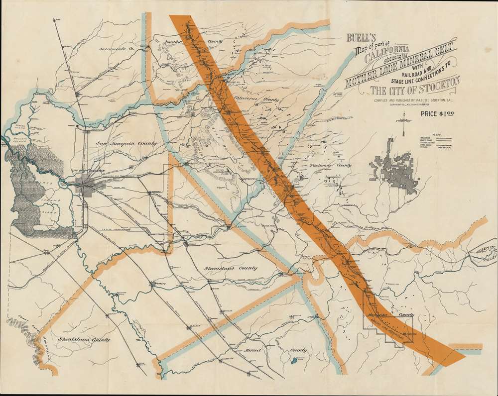
Buell's Map of part of California showing the Mother Lode Mineral Belt with Rail Road and Stage Line Connections to The City of Stockton.
1898 (undated) 22 x 29 in (55.88 x 73.66 cm)
1898 (undated) 22 x 29 in (55.88 x 73.66 cm)
Description
A striking example of Park Arbington Buell's important 1898 map of the Mother Lode in the vicinity of Stockton, California. The booklet is hand signed by Buell and dedicated to mining engineer Louis Janin. Coverage extends from Bouldin Island (just west of Stockton) to the Yosemite Valley and from Amador County south to the Merced River, embracing San Joaquin, Calaveras, Amador, Tuolumne, Stanislas, and Mariposa Counties. The 'Mother Lode' mining belt is boldly highlighted in orange. Throughout the cartographer has marked the largest and most important mines, as well as railroad connections with the Buell yards in Stockton.
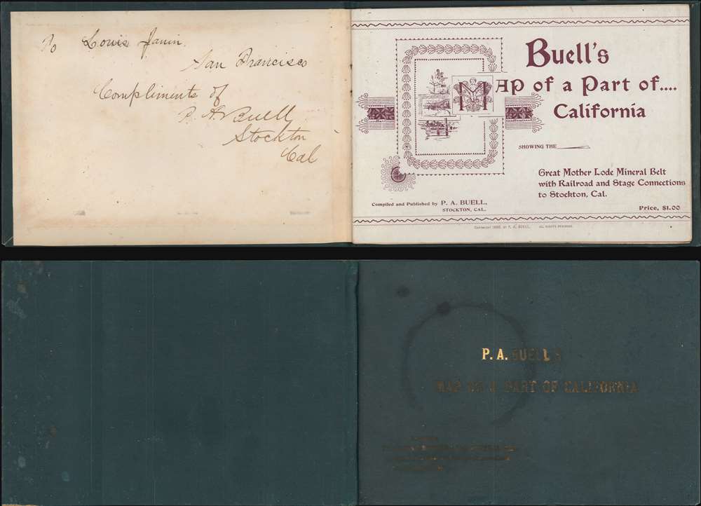
The Accompanying Booklet
The map is accompanied by a booklet promoting Buell's prosperous lumber business to the mining industry. Mining then expended phenomenal quantities of timber to shore up diggings, build flumes, mills, and smelting operations. Buell ran one of the largest mills in California that specialized in 'heavy timbers for mines and mills'. The Buell mills were also strategically located next to several major railroad lines, so his timber could be easily transported almost anywhere in the Sacramento Valley. His intent for the accompanying map was thus clear, but if not, he adds,The accompanying map shows the location of the mining section of Amador, Calaveras, Tuolumne and Mariposa counties, also the best way to reach the same by rail … From these … terminals stages make close connections with all the mining towns. The towns along the lode are connected by stage lines as shown in the map. … This is unquestionably the richest and most accessible mining country in the world and is worthy of careful investigation as much of it is still undeveloped. For further particulars, apply to P. S. Buell.
Signed and Dedicated to Prominent Mining Engineer
This example of the booklet is signed and inscribed by Buell to Louis Janin. Janin (1837 - 1914) was a mining engineer who made his name by applying European mining technology to the Comstock Lode. By 1898, when he met Buell in San Francisco, Janin was a wealthy and influential man visiting San Francisco as a delegate for the Miners' Association of the City and County of San Francisco as well as a judge at the State Fair. Around this time, Janin incidentally hired a young office boy who showed such promise he was immediately elevated to an engineering position - this was future U.S. president Herbert Hoover's first job.The California Mother Lode
The 'Mother Lode' is a long alignment of hard-rock gold deposits stretching northwest-southeast in the Sierra Nevada Mountains of California. It was discovered early in the California Gold Rush when placer deposits in streams led prospectors to search for the source or 'mother'. The source was a zone some 1 to 4 miles wide and 120 miles long between Georgetown on the north and Mormon Bar on the South. Once placer deposits were exhausted, miners turned to the mother lode, digging deep mines all along the corridor. During the years following the California Gold Rush, the Mother Lode was one of the most productive gold-producing districts in the world. Individual gold deposits within the Mother Lode include gold-bearing quartz veins up to 50 feet thick and thousands of feet in length.Publication History and Census
This map was published by P. A. Buell and Company in Stockton, California, in 1898. There is no printer named on either the map or in the booklet. The map and pamphlet are rare on the market. The OCLC identifies examples at Yale, the Huntington Library, the California State Library, the Bancroft, and the Denver Public Library.Cartographer
Park Arbington Buell (September 13, 1859 - April 4, 1900) was a prominent California businessman active in Stockton in the late 19th century. Buell was born in Richfield, Ohio but moved to Napiersville, Illinois, when he was 4. His father, who was a farmer, died in 1862, after which Buell was able to successfully take over and run the family farm. The family relocated to Santa Rosa, California, arriving on January 9, 1875. From that date, to 1881, he worked as a lumberman for the Koral Brothers Mill. He moved to Stockton in 1881, taking work with White and Thomas, who were then building a new mill. In 1885 or 1886, he established his own Stockton lumber yard and began constructing a mill on Center Street. The business grew into a major concern and Buell became very wealthy and prominent in Stockton commercial, political, and social affairs. While visiting San Francisco in 1900, he died suddenly of kidney failure. More by this mapmaker...
Condition
Very good. Slight wear on old fold lines.