This item has been sold, but you can get on the Waitlist to be notified if another example becomes available, or purchase a digital scan.
1824 Smith Chart of the World's Mountains and Rivers
MountainsRivers-smith-1824$1,000.00

Title
A Combined View of the Principal Mountains and Rivers in the World; accompained by a table shewing their relative Heights and Lengths.
1824 (dated) 22 x 30 in (55.88 x 76.2 cm) 1 : 24000
1824 (dated) 22 x 30 in (55.88 x 76.2 cm) 1 : 24000
Description
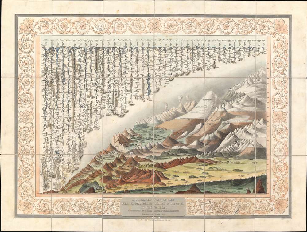
A groundbreaking convention establishing map of extreme scarcity, this is Charles Smith and W. R. Gardner's 1824 comparative mountains and rivers of the world chart. It is the second known iteration of a comparative chart to depict both mountains and rivers in the same plate, preceded only by the Gardner/Darton chart of 1823 – thus defining a cartographic style that would flourish throughout the remainder of the 19th century.
Mountains So High
The comparative mountains section, occupying the lower right half of this chart, details the principal mountains of the world. Ranges are color coded to show different types of vegetation and numerically referenced to tables in the lower right quadrant. The elevations of several important cities including Paris, Rome, London, Geneva, Mexico, Bogota, and Quito, among others, are noted. There are also extensive notations on vegetation, volcanic activity, and lichen, much of which is no doubt influenced by Humboldt. Notes curiosities that would have been relevant at the time, such as 'The Greatest Altitude of the Growth of Peruvian Bark', 'The Glacier of Maladetts', the 'Table Land of Pamar', and the 'Greatest Altitude attained by Humboldt 19400 ft'.Rivers So Long
The upper left portion of this chart is dominated by the world's greatest rivers. Smith and Gardner attempt not only to express the lengths of the various rivers, but also details regarding their course and sources. All along each river important lakes, cities, directions, and distance measurements are noted. Here the Amazon is identified as the world's greatest river at some 3850 miles, followed by the Mississippi at 3760 miles. The Nile comes up a sad fifth at just 3240 miles, though admittedly its full length had yet to be explored.Publication History and Census
This map was issued and sold independently by Charles Smith and W. Gardner. Examples were issued in dissected case format (as in this example), as a wall map, and as a flat separate sheet. That Wolter, whose study of comparative charts is the most significant scholarly approach to this material currently published, was not aware of this map is suggestive of its extreme rarity. We note perhaps 3 in instructional collections. It was updated and reissued in 1825, 1830, and 1835. After which the plates passed to the New York based Colton firm, who issued editions in 1850 and 1853 before replacing the decorative border and incorporating it into their 1855 atlases. A rare discovery that will not likely appear on the market again soon.CartographerS
William R. Gardner (fl. c. 1810 - c. 1850) was and English engraver active in London during the first half of the 19th century. His offices were at 867 Strand Street, London. Gardner worked with many of the most prominent London publishers of his day including Charles Smith and William Darton. His most significant contribution to the world of cartography is his 1823 publication, along with publisher William Darton, of the first composite comparative mountains and rivers chart. More by this mapmaker...
Charles Smith (1768 - 1854) was 19th century British publisher of maps, atlases, and charts, most of which focused on England and London. Smith was appointed map seller to the Prince of Wales in 1809. His early work stylistically resembles the work of Pinkerton, Cary, and Thomson, though on a much smaller scale. From 1826 to 1854 the business traded as Charles Smith and Son. After Charles Smith's death in 1852 the it was taken over by his son William Smith, and later his grandson Guildford Smith (1838 - 1917), who continued to publish maps well into the 20th century. The younger Smith is best known for his introduction of the 'Tape Indicator Map'. This map, which came with a tape measure, enabled users to triangulate their location based coordinates given in an attached guide. The firm was taken over by George Philip in 1916. Learn More...
Condition
Very good. Dissected and laid on original linen, with original slipcase.
References
Rumsey 11453.000 (Colton). OCLC 912875463.