
Smith, Charles

Charles Smith (1768 - 1854) was 19th century British publisher of maps, atlases, and charts, most of which focused on England and London. Smith was appointed map seller to the Prince of Wales in 1809. His early work stylistically resembles the work of Pinkerton, Cary, and Thomson, though on a much smaller scale. From 1826 to 1854 the business traded as Charles Smith and Son. After Charles Smith's death in 1852 the it was taken over by his son William Smith, and later his grandson Guildford Smith (1838 - 1917), who continued to publish maps well into the 20th century. The younger Smith is best known for his introduction of the 'Tape Indicator Map'. This map, which came with a tape measure, enabled users to triangulate their location based coordinates given in an attached guide. The firm was taken over by George Philip in 1916.
Waning days of colonialism in the West Indies.
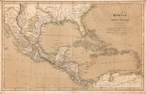
Mexico and the West Indies.
$500.00
Acquire
- Digital Map Information
- Suitable for large format printing
- DPI: 600
- File Size: 36.13 MB
- File Type: ZIP / TIFF
- ICC color profile embedded
- Delivered instantly via download link
This is a striking old color example of Charles Smith rare 1826 map of Mexico, the West Indies, and Central America. (more details)
Uncommon separate issue map of New York.

Map of the State of New York Showing the location of Boundaries of Counties and Townships Cities, Towns and Villages: the Courses of Rail Roads, Canals and Stage Roads.
$125.00
Acquire
- Digital Map Information
- Suitable for large format printing
- Full resolution TIFF file
- ICC color profile embedded
- Delivered instantly via download link
This is a separate-issue 1858 J. Calvin Smith and J. Disturnell pocket map of New York. (more details)