This item has been sold, but you can get on the Waitlist to be notified if another example becomes available, or purchase a digital scan.
1840 Black Map of Comparative Mountains and Rivers
MountainsRivers2-black-1840$175.00

Title
Physical Geography.
1840 (undated) 10 x 14.5 in (25.4 x 36.83 cm)
1840 (undated) 10 x 14.5 in (25.4 x 36.83 cm)
Description
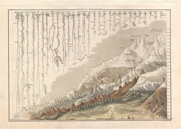
A fine example of Adam and Charles Black's 1840 comparative mountains and rivers of the world chart. Charts of this kind were first introduced in England around 1823 and became a common feature in atlases throughout the 19th century. The present example is admired as one of the more attractive British examples of the style.
The comparative mountains section, occupying the lower right half of this chart, details the principle mountains of the world. Ranges are color coded to show different types of vegetation. The elevations of a number of important cities including Riobamba, London, Gibraltar, Toluca, and Quito, among others, are noted. There are also extensive notations on vegetation, volcanic activity, and lichen, much of which is no doubt influenced by Humboldt. The Himalayan peak Dhaulagiri is identified as the world's greatest mountain. Even the ballooning feat of Gay-Lussac who attained an altitude of 7000 meters in 1808 is noted. It is interesting to note that while the style is international, Black has tooled this map to appeal to his British client base. Sites of exceptional interest to the British Islanders, including the 'highest inhabited place in Scotland' and the Convent of St. Gothard, are specifically identified.
The upper left portion of this chart is dominated by the world's greatest rivers. Black attempts not only to express the lengths of the various rivers, but also details regarding their course and sources. Here the Mississippi is identified as the world's greatest river at some 3610 miles, followed by the Amazon at 3130 miles. The Nile comes up a sad fifth at just 2700 miles, though admittedly its full length had yet to be explored.
This map was engraved by G. Aikman for issue in the 1840 edition of Black's General Atlas.
Cartographer
Charles and Adam Black (fl. 1807 - present) were map and book publishers based in Edinburgh. Charles and his uncle, Adam, both of Edinburgh, Scotland, founded their publishing firm in 1807. They published a series of maps and atlases throughout the 19th century. In addition to an array of atlases, the Black firm is known for their editions of the Encyclopedia Britannica (1817 - 1826) and the first publishing of Sir Walter Scott's novels in 1854. In 1889 the A. & C. Black publishing house moved to London where it remains in operation to this day. More by this mapmaker...
Source
Hall, Sydney, Black's General Atlas: A series of Fifty-Four Maps from teh Latest and Most Authentic Sources, Engraved on Steel, In the First Style of the Art, (Edinburgh: Adam and Charles Black) 1840.
Condition
Very good condition. Blank on verso.
References
Rumsey 2305.003 (1854 edition). Philips (atlases) 4334.