This item has been sold, but you can get on the Waitlist to be notified if another example becomes available, or purchase a digital scan.
1890 Rand Avery Map of Mount Desert Island and the Coast of Maine
MountDesertIsland-randavery-1890$175.00

Title
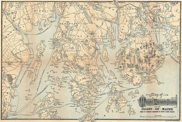
Map of Mount Desert Island and the Coast of Maine.
1890 (undated) 15.5 x 23 in (39.37 x 58.42 cm) 1 : 142560
1890 (undated) 15.5 x 23 in (39.37 x 58.42 cm) 1 : 142560
Description
This is an attractive c.1890 map of Mount Desert Island and the coast of Maine issued by the Passenger Department of Boston and Maine Railroad. It covers Mount Desert Island and vicinity from Lincolnville and Rockland east to Winter Harbor and north as far as Pattens Pond and Verona. Throughout the map notes roads, towns and steamship and ferry routes running between several islands, including those of Blue Hill Steamship Co., the Maine Central Railroad ferry, the Bangor steamers, etc. The railway route to Portland and Boston is also noted. This map was issued by the Passenger Department of Boston and Maine Railroad and published by Rand Avery Supply Company, Boston.
Condition
Very good. Minor wear and toning along original fold lines. Minor spotting. Professionally flattened and backed with archival tissue.
References
Rumsey 4419.002.