This item has been sold, but you can get on the Waitlist to be notified if another example becomes available, or purchase a digital scan.
1902 Rand Avery Map of Mount Desert Island and the Coast of Maine
MountDesertIsland-randavery-1902$175.00

Title
Map of Mount Desert Island and the Coast of Maine.
1902 (undated) 15.25 x 23 in (38.735 x 58.42 cm) 1 : 142560
1902 (undated) 15.25 x 23 in (38.735 x 58.42 cm) 1 : 142560
Description
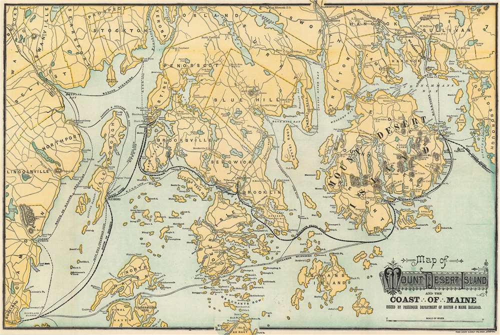
This is an attractive 1902 Rand Avery map of Mount Desert Island and the coast of Maine issued by the Passenger Department of Boston and Maine Railroad. The map depicts Mount Desert Island and vicinity from Lincolnville and Rockland east to Winter Harbor and north as far as Pattens Pond and Verona. Roads and towns are illustrated throughout, and steamship and ferry routes running between several islands are identified, including those of Blue Hill Steamship Co., the Maine Central Railroad ferry, and the Bangor steamers. The railway route to Portland and Boston is also noted.
This map was issued by the Passenger Department of Boston and Maine Railroad and published by Rand Avery Supply Company, Boston in 1902.
Acadia National Park
Though over a decade before the establishment of Acadia National Park, today Mount Desert Island is celebrated as the home of part of this magnificent national treasure. Acadia was initially established as Sieur de Monts National Monument by President Woodrow Wilson in July 1916. In February 1919, the area's status was officially changed from a National Monument to a National Park, making it the first National Park east of the Mississippi River. With the change to a National Park came a name change as well, with the region now being known as Lafayette National Park. It would not be until January 1929 that the park would be renamed Acadia National Park. Acadia is unlike most other National Parks as its creation was encouraged by numerous private individuals. One of these was John. D. Rockefeller, Jr. Rockefeller purchased a summer home in Bass Harbor in 1910, and began buying land in the park with the goal of creating a system of carriage roads as means of making more accessible to visitors what Rockefeller thought was 'one of the greatest views in the world.'This map was issued by the Passenger Department of Boston and Maine Railroad and published by Rand Avery Supply Company, Boston in 1902.
Cartographer
Rand, Avery, and Company (1851 – 1886) was a Boston based book and map printer active in the late 19th century. The company was founded in 1851 by George Curtis Rand (December 13, 1819 – December 30, 1878) and his brother-in-law Abraham Avery (November 15, 1824 - April 3, 1893). George C. Rand was a brother to William H. Rand of Rand, McNally, and Company of Chicago. George C. Rand was born in Woodstock, Vermont, to Baptist minister John Rand (1781 – 1855) and his wife. Rand began working in the printing industry from at least the 1840s, wherein he mostly produced religious tracts. He married Julia Avery in 1851 and brought his brother-in-law, Abraham Avery, into the business, renaming the firm Rand, Avery, and Company. Avery was born in Wibraham, Massachusetts and studied at Wesleyan University, which his father helped to found. Rand, Avery, and Company was based in Cornhill, Boston, and was, for a time, they were the largest printers in New England. Such works as Uncle Tom's Cabin were included in their catalog. Avery retired when Rand died in 1878, but the firm continued to publish under another generation of managers, including Rand's son, Avery L. Rand, until at least 1886. They also took on a fourth partner, Orrin F. Frye, and published as Rand, Avery, and Frye. After retiring Avery moved to Los Angeles where he died in 1893. It appears that this firm also published under the name the Rand Avery Supply Company. More by this mapmaker...
Condition
Very good. Even overall toning. Light wear along original fold lines. Blank on verso.
References
Rumsey 4419.002.