This item has been sold, but you can get on the Waitlist to be notified if another example becomes available, or purchase a digital scan.
1888 U.S.C.G.S. Nautical Chart / Map of Mount Desert Island, Maine
MountDesertIsland-uscgs-1888$700.00

Title
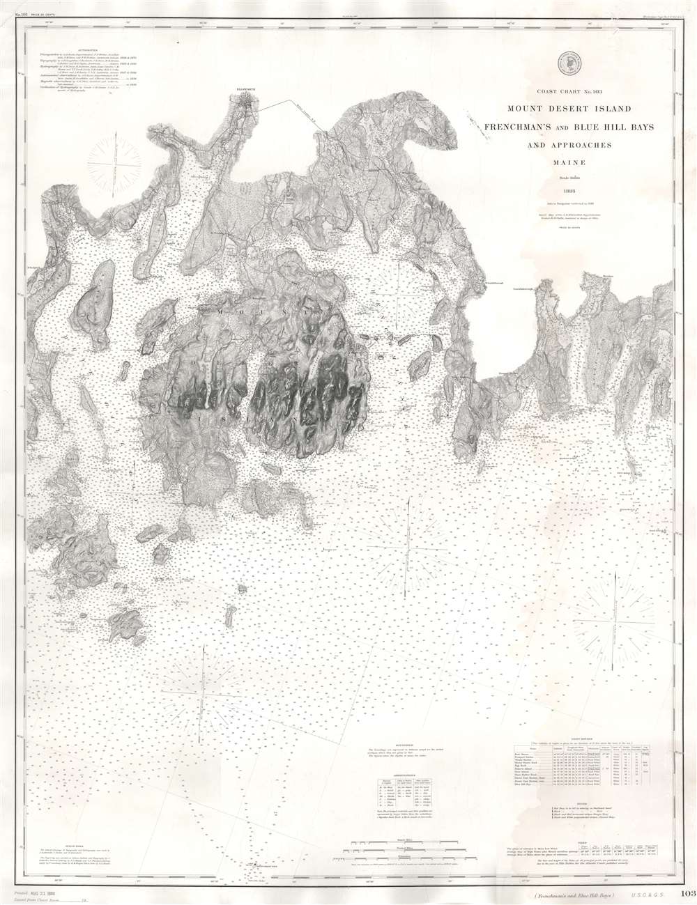
Coast Chart No. 103 Mount Desert Island Frenchman's and Blue Hill Bays and Approaches Maine.
1888 (dated) 44.25 x 32.5 in (112.395 x 82.55 cm) 1 : 80000
1888 (dated) 44.25 x 32.5 in (112.395 x 82.55 cm) 1 : 80000
Description
This is an 1888 U.S. Coast and Geodetic Survey nautical chart or maritime map of Mount Desert Island, Frenchman's Bay, and vicinity, Maine. With Mount Desert Island situated slightly to the left of center, the map depicts from New Sedgwick and Blue Hill Neck to Pigeon Hill and Pigeon Hill Bay. Mount Desert Island's celebrated topography is illustrated in detail. Roads traverse the island and individual residences are marked but not labeled. Mountain peaks, harbors, points, coves, ponds, and lakes are all identified as well. Other islands throughout are also illustrated, along with harbors, necks, coves, and bays. As this is a nautical chart, countless depth soundings are indicated.
Mount Desert Island
Popularized as a vacation destination during the 19th century, Mount Desert Island is renowned for its exceptional natural beauty. First brought to public attention by painters of the Hudson River School, tourists and nature lovers began flocking to the island in the 1860s. By 1880, 8 years before the present map was published, the island hosted thirty grand hotels. By the 'Gay Nineties', American social elites and business magnates, including the Rockefellers, Fords, Vanderbilts, and Carnegies, built summer homes on the island's most desirable land. Eventually the Rockefellers acquired most of the island, donating it to the Federal government as a public recreation area, Acadia National Park.Acadia National Park
Mount Desert Island, so named because of its many bald rocky mountaintops, has been a tourist destination since the mid-19th century, when it was discovered by outsiders, artists, journalists, Hudson River School artists, and other patrons, known collectively as the 'Rusticators.' Undaunted by crude accommodations and simple food, they sought out local fishermen and farmers for accommodation and guidance. Summer after summer, the rusticators returned to renew friendships with local islanders and, most of all, to savor the fresh salt air, scenery, and relaxed pace. Soon the villagers' cottages and fishermen's huts filled to overflowing, and by 1880, 30 hotels competed for vacationers' dollars. Tourism was becoming the island's primary industry. Drawing the attention of the wealthy and influential, the island was designated as Sieur de Monts National Monument by President Woodrow Wilson in July 1916. In February 1919, the area's status was officially changed from a National Monument to a National Park, making it the first National Park east of the Mississippi River. With the change to a National Park came a name change as well, to Lafayette National Park. It was not until January 1929 that the park was given its current name, Acadia National Park. Acadia is unlike most other National Parks as its creation was encouraged by numerous private individuals. One, John. D. Rockefeller, purchased a summer home in Bass Harbor in 1910. Rockefeller began buying up land on the island with the goal of creating a system of carriage roads to make 'one of the greatest views in the world' accessible to all.Publication History and Census
This map was created and published by the United States Coast and Geodetic Survey while Julius Hilgard was Superintendent. This chart was first issued in 1883 and numerous subsequent editions were published, with the current example bearing updates to 1888. An empty OCLC reference exists for this map, suggesting that a former cooperative member created it. Examples of other editions are present in institutional collections.CartographerS
The Office of the Coast Survey (1807 - present) founded in 1807 by President Thomas Jefferson and Secretary of Commerce Albert Gallatin, is the oldest scientific organization in the U.S. Federal Government. Jefferson created the "Survey of the Coast," as it was then called, in response to a need for accurate navigational charts of the new nation's coasts and harbors. The spirit of the Coast Survey was defined by its first two superintendents. The first superintendent of the Coast Survey was Swiss immigrant and West Point mathematics professor Ferdinand Hassler. Under the direction of Hassler, from 1816 to 1843, the ideological and scientific foundations for the Coast Survey were established. These included using the most advanced techniques and most sophisticated equipment as well as an unstinting attention to detail. Hassler devised a labor intensive triangulation system whereby the entire coast was divided into a series of enormous triangles. These were in turn subdivided into smaller triangulation units that were then individually surveyed. Employing this exacting technique on such a massive scale had never before been attempted. Consequently, Hassler and the Coast Survey under him developed a reputation for uncompromising dedication to the principles of accuracy and excellence. Unfortunately, despite being a masterful surveyor, Hassler was abrasive and politically unpopular, twice losing congressional funding for the Coast Survey. Nonetheless, Hassler led the Coast Survey until his death in 1843, at which time Alexander Dallas Bache, a great-grandson of Benjamin Franklin, took the helm. Bache was fully dedicated to the principles established by Hassler, but proved more politically astute and successfully lobbied Congress to liberally fund the endeavor. Under the leadership of A. D. Bache, the Coast Survey completed its most important work. Moreover, during his long tenure with the Coast Survey, from 1843 to 1865, Bache was a steadfast advocate of American science and navigation and in fact founded the American Academy of Sciences. Bache was succeeded by Benjamin Pierce who ran the Survey from 1867 to 1874. Pierce was in turn succeeded by Carlile Pollock Patterson who was Superintendent from 1874 to 1881. In 1878, under Patterson's superintendence, the U.S. Coast Survey was reorganized as the U.S. Coast and Geodetic Survey (C & GS) to accommodate topographic as well as nautical surveys. Today the Coast Survey is part of the National Oceanic and Atmospheric Administration or NOAA as the National Geodetic Survey. More by this mapmaker...
Julius Erasmus Hilgard (January 7, 1825 - May 9, 1890) was a German-American engineer and Director of the United States Coast Survey. Born in Zweibrüken, Rhenish Bavaria, he and his family emigrated to the United States in 1835. They arrived in New Orleans on Christmas Day and traveled from there to a farm in Belleville, Illinois. Hilgard went to Philadelphia in 1843 to study engineering. It was in Philadelphia that Hilgard met Professor Alexander Bache, the recently appointed Superintendent of the United States Coast Survey. In 1845, Bache gave Hilgard a position with the Coast Survey, although his official appointment was delayed for some reason until December 28, 1846. Hilgard worked with the Coast Survey off and on for the rest of his life. At the outbreak of the Civil War, Hilgard was engaged in a prominent business enterprise in Paterson, New Jersey, but Bache convinced him to return to the Coast Survey to supplement in the war effort. In 1862, Hilgard 'assumed charge of the Coast Survey office', taking on the duties of Superintendent in lieu of Bache, who had, by this time, become extremely ill. Upon Bache's death in 1867, Hilgard became the de-facto Superintendent as well as the assistant in charge of the office. He served as such until February 1867 when Benjamin Pierce was appointed Superintendent. Hilgard continued to work for the Coast Survey under Pierce as 'assistant in charge of office' until he was formally appointed Superintendent in 1881, a position he held until 1885 when he was forced to resign due to illness. He died 5 years later. Learn More...
Richard Dominicus Cutts (September 21, 1817 - December 13, 1883) was an American army officer and civil servant. Born in Washignton, D.C., he attended Georgetown University and graduated in 1835. He volunteered for the Union Army in 1861 and was commissioned as a Colonel and Aide-de-Camp. He served on Major General Henry Wager Halleck's staff until he was made Chief of Staff under Lieutenant General Ulysses S. Grant. He was brefetted to Brigadier General on March 13, 1865, and was mustered out on June 1, 1865. He spent decades working for the U.S. Coast Survey and then the U.S. Coast and Geodetic Survey, where he rose to the position of Assistant in Charge of the Office. Cutts died on December 13, 1883, after contracting an illness during his return from a geodetic conference in Rome. He married Marth Jeffereson Hackley on December 16, 1845. Learn More...
Condition
Very good. Mounted on linen. Exhibits minimally disfiguring dampstaining along the full right side of the map.
References
OCLC 967967436.