This item has been sold, but you can get on the Waitlist to be notified if another example becomes available, or purchase a digital scan.
1955 U.S. Air Force Aeronautical Chart or Map of Emi Koussi, Chad
MountKoussi-usaf-1955$50.00

Title
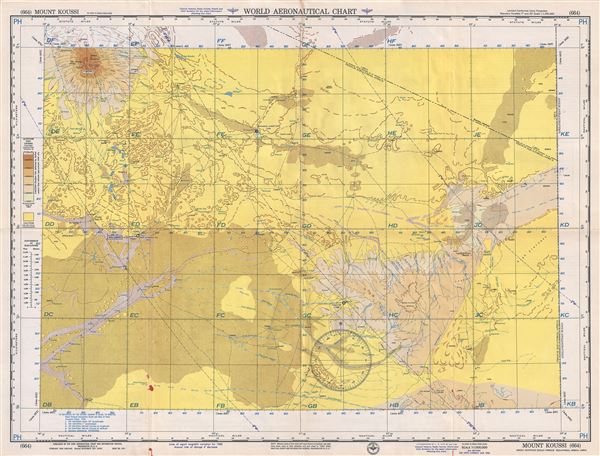
Mount Koussi Anglo-Egyptian Sudan-French Equatorial Africa-Libya.
1955 (dated) 22 x 29 in (55.88 x 73.66 cm) 1 : 1000000
1955 (dated) 22 x 29 in (55.88 x 73.66 cm) 1 : 1000000
Description
This is a scarce 1955 U.S. Air Force aeronautical chart or map of Mount Koussi or Emi Koussi in the central Sahara in northern Chad. It covers from the high pyroclastic shield volcano of Emi Koussi, the highest mountain in the Sahara, southward to Koro Toro and east to include the southernmost part of Libya. The cities of Faya – Largeau, the largest city in northern Chad, Ounianga Kebir and Fada are noted. The map is highly detailed, noting communes, valleys, mountains, deserts, rivers, dunes, cities, towns, and other hydrographical and topographical features essential for the air pilot. Verso of this chart features legends and a world aeronautical chart index. This chart was published by the USAF Aeronautical Chart and Information Service, Washington 25, D.C., and was issued as chart no. 664. First issued in 1948, this is the third edition revised to May 1955.
Condition
Very good. Minor wear and toning along original fold lines. Minor spotting.