This item has been sold, but you can get on the Waitlist to be notified if another example becomes available, or purchase a digital scan.
1855 Jefferson Davis Map of California from Pyramid Lake to the Sacramento River
MudLakestoPacific-davis-1855$125.00

Title
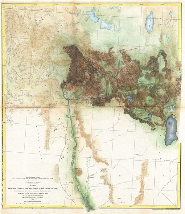
Explorations and Surveys for a Rail Road Route from the Mississippi River to the Pacific Ocean. War Department. Route near the 41st Parallel. Map No. 4. From the Mud Lakes to the Pacific Ocean; from Explorations and Surveys made under the direction of the Hon. Jefferson Davis Secretary of War.
1855 (dated) 21 x 18 in (53.34 x 45.72 cm)
1855 (dated) 21 x 18 in (53.34 x 45.72 cm)
Description
This is a rare and important 1855 map of parts of California prepared for the Pacific Railroad Survey. Covers from Pyramid Lake to the Sacramento River. Extends north to the California border and south as far as Fremont and Marysville. Offers superb topographical detail – most attributable to the expedition topographer F. W. Egloffstein. This is the fourth of a series of four maps drawn and surveyed By Captain E. G. Beckwith with the intention of determining the best route for a railroad from the Mississippi to the Pacific. Delineates two proposed railroad routes through the Sierra Nevada Mountains. The proposed lines runs northwest from the Valley of the Mud Lakes to the Madelin Plains and then westward along the Pitt River towards Shasta City, where it turns south along the Scaramento River. Also notes an earlier southerly route proposed route explored in 1854. Notes Mount Sahsta, Red Bluffs, Marysivll, Auburn, and the head of Navigation on the Sacramento River. The southern part of the map details part of the California Gold Region, including Nevada, Auburn, Colima, Pacerville, Marysville and Fremont. Prepared under the direction of Secretary of War Jefferson Davis by Captian E. G. Beckwtih and F. W. Egloffstein. Engraved by Selmar Siebert in Washington D.C.
Cartographer
The Pacific Railroad Surveys (1853 - 1855) were established in 1853 with the goal of identifying the best possible routes for a transcontinental railroad from the Mississippi to the Pacific. The need for transcontinental railroad made itself evident shortly after the California Gold rush when the westward expansion was at its heights. The federal government, acting under the Sectary of War, Jefferson Davis (of Civil War fame), initiated a series of expeditions of the western territories. These expeditions included surveyors, cartographers, artists, zoologists, botanists and geographers. The resultant work, a 12 volume compendium entitled Reports of Explorations and Surveys, to ascertain the most practicable and economical route for a railroad from the Mississippi River to the Pacific Ocean eventually led to the constructions of several different transcontinental railroads. More by this mapmaker...
Source
Reports of Explorations and Surveys, to Ascertain the Most Practicable and Economical Route for a Railroad From the Mississippi River to the Pacific Ocean. Made Under the Direction of the Secretary of War, In 1853-56, According to Acts of Congress of March 3, 1853, May 31, 1854, and August 5, 1854. Volume XI. Washington: George W. Bowman, Printer. 1861. 36th Congress, 2d Session, Senate, Ex. Doc. (Washington) 1855.
Condition
Very good. Some light spotting and toning on original fold lines. Else clean. Backed with archival tissue.
References
Rumsey, 0693.031. Wheat, C., The Mapping of the Transmississippi West, 1540-1861, #825. Library of Congress, Map Division, G4361.P3 1855 .E34 RR 168. University of Nevada, Las Vegas, Map Division, G4051.P3 1855.E553 no.4 c.2.