1938 Survey of India City Plan of Nainital, Uttarakhand
Nainital-surveyofindia-1938$1,500.00


Title
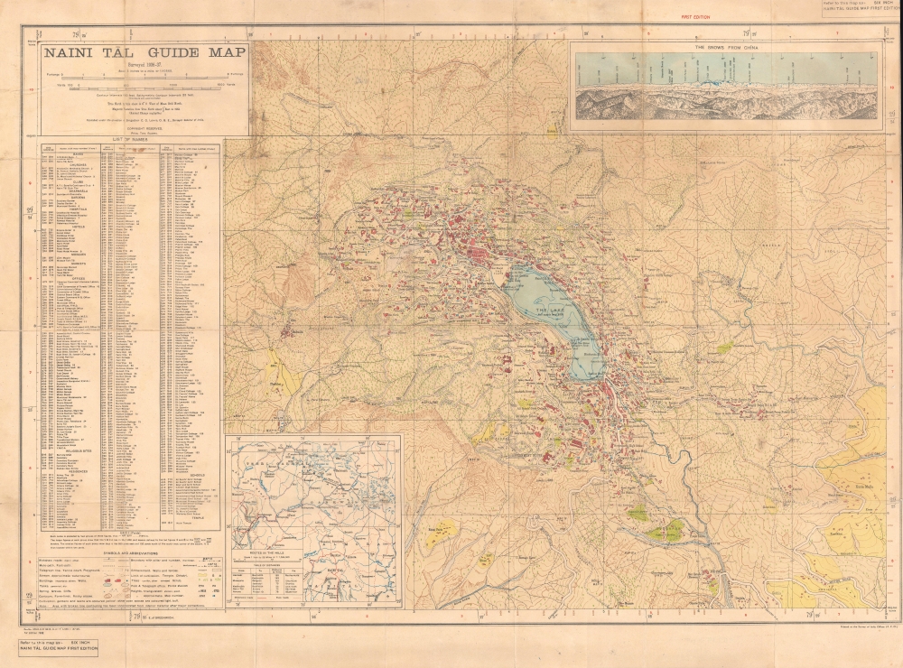
Naini Tāl Guide Map.
1938 (dated) 22 x 31.75 in (55.88 x 80.645 cm) 1 : 10560
1938 (dated) 22 x 31.75 in (55.88 x 80.645 cm) 1 : 10560
Description
An impressive 1938 topographical city plan or map of Nainital in the United Provinces of India (now Uttarakhand) produced by the Survey of India. It presents the steep topography of the area at the foothills of the Himalayas as well as structures throughout the city.
On the northwest side of the lake is an area labeled 'the Flats,' which includes the city's Assembly House and main temple. Both structures were somewhat recent reconstructions, as their predecessors had been swept away in a terrible landslide in 1880. In the hills to the east of the city are a grouping of military structures, including barracks and housing for soldiers' family members.
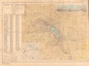
At bottom-left, an inset map displays 'Routes in the Hills' to the north of the city. At top-right, a profile of 'The Snows from Chīna' displays the Garhwal Himalayan peaks (including Nanda Devi and Kamet, the second and third tallest mountains in India) to the north, as viewed from Chīna, a mountain on the northwestern outskirts of the city.
A Closer Look
The city of Nainital (here as Naini Tāl) and its environs are displayed, combining a topographic map and city plan in the style distinctive of the Survey of India's city 'guide map' series (for comparison, see their 1936 guide map of Peshawar previously sold by us). A legend at bottom-left indicates symbols and lines used for topographical features and human-made structures. At left is a highly detailed index of offices, hotels, residences, banks, marketplaces, places of worship, schools (the city was known for its relatively large number of 'European' schools), and more, along with their grid coordinates using the yard measurements in the border (explained below the index).On the northwest side of the lake is an area labeled 'the Flats,' which includes the city's Assembly House and main temple. Both structures were somewhat recent reconstructions, as their predecessors had been swept away in a terrible landslide in 1880. In the hills to the east of the city are a grouping of military structures, including barracks and housing for soldiers' family members.
At bottom-left, an inset map displays 'Routes in the Hills' to the north of the city. At top-right, a profile of 'The Snows from Chīna' displays the Garhwal Himalayan peaks (including Nanda Devi and Kamet, the second and third tallest mountains in India) to the north, as viewed from Chīna, a mountain on the northwestern outskirts of the city.
Zincography
At bottom-right, the map is noted as being printed at the Survey of India Offices (P. Z. O.), meaning photozincograph office. Zincography, or 'zinco' for short, is a planographic printing process similar to lithography. The process was known as early as 1801, when lithography inventor Alois Senefelder (1771 - 1834), in his original English patent for lithography, mentioned the possibility of using zinc plates over traditional limestone. The first zincographic process was subsequently patented in 1834 by Federico Lacelli. The process operates like traditional stone-lithography wherein ink applied to the plate is repelled by the hygroscopic areas, and attracted to the fuchsine areas. It offers several advantages, most importantly, zinc plates are lighter and cheaper than lithographic stones, economizing the process considerably. As such, the process was embraced by various cartographic agencies that demanded mobility and economy, among them the British Ordinance Survey, the French Bureau Topographique, and many military mapping agencies. It was followed by photo-zincography, photo-lithography, and photogravure.Publication History and Census
This map was produced by the Survey of India in 1938, relying on surveys conducted in 1936 - 1937. This is the first edition of the map, only noted among the holdings of the British Library and the University of Reading. A later edition appeared in 1945 (OCLC 49413594), which is held by the University of Minnesota and the University of Oxford.Cartographer
Survey of India (1767 - Present) is India's central engineering agency in charge of mapping and surveying the country. It was founded in 1767 by Major James Rennell, who took the post of first Surveyor General, with the mission to map and consolidate the territories of the British East India Company. The Survey undertook the Great Trigonometrical Survey between 1802 and 1852 in an attempt to accurately measure the Indian Subcontinent - considered one of the greatest feats of mapping of all time. It also sponsored clandestine surveys, at times disguised as Buddhist pilgrims, to infiltrate and map Tibet, then a closed country. With India's independence in 1947, the Survey was folded into the new Indian government, which it remains part of to this day. More by this mapmaker...
Condition
Good. Wear and some foxing along fold lines, with loss at fold intersections, repaired on verso.
References
OCLC 556715517, 1114853665.