
This item below is out of stock, but another example (left) is available. To view the available item, click "Details."
Details
1889 Ewer Map of Nantucket Island, Massachusetts w/ Old Colony Line Ad
1889 (undated) $1,000.00
1869 Ewer Map of Nantucket Island, Massachusetts
Nantucket-ewer-1869$1,375.00

Title
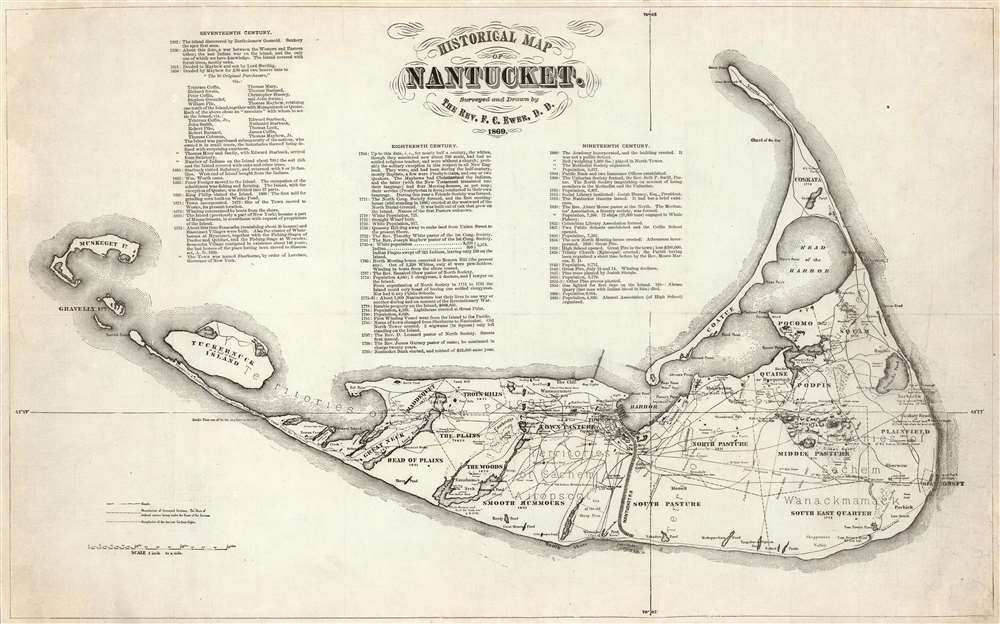
Historical Map of Nantucket.
1869 (dated) 12.25 x 20 in (31.115 x 50.8 cm) 1 : 68000
1869 (dated) 12.25 x 20 in (31.115 x 50.8 cm) 1 : 68000
Description
This attractive c. 1869 map is a reduced version of Reverend F. C. Ewers groundbreaking, 1869 wall map of Nantucket. This variant - by an unknown printer, likely in Boston was published shortly after the first edition. Three columns of text provide the highlights of of Nantucket's history from its discovery by Bartholomew Gosnold in 1602 to the momentous 1865 organization of the island's high school Alumni Association.
The Ewer Map
The Nantucket historian Joseph Garver provides an excellent descriptionEwer’s map provides a detailed synopsis of Nantucket’s history, beginning with Gosnold’s sighting of the island in 1602. The chronological table identifies the major stages in Nantucket’s development-its early settlement and land divisions, the evolution from shore to deep-sea whaling, the establishment of religious and educational institutions, and the development of the transportation network connecting Nantucket with the mainland (and Nantucketers with one another). Ewer also notes events that marked the transition from one era to the next-the first island whaler to seek its prey in the Pacific (1791), the death of the last Indian (1822), the great fires of 1836 and 1846, and the first gaslight in 1854. In a more graphic form the map indicates the sites of old settlements and burial grounds, as well as the boundaries of sachem rights, the former shoreline, old fishing stages, and whaling stations. (Garver, G. Surveying the Shore, p. 115.)
An Early Reduction
Other reduced iterations of this map appear on the market, notably the one printed in 1886 as a promotion for the Old Colony Line of steamships. This version is larger than the 1886, and captures the elegant lines of the original.Publication History and Census
This map has a complex, confusing, and little researched publication history. It was originally drawn and published by Ferdinand Cartwright Ewer in 1869. That edition was large, measuring more than 40 inches wide. The present example corresponds to the one in the collection of New York Public Library; we have not seen other examples printed to these dimensions.Cartographer
Ferdinand Cartwright Ewer (1826 - 1883) was born on May 22nd of 1926 in town of Nantucket on the Massachusetts island of the same name. Ewer's father, a prominent Nantucket businessman, moved his family to Providence Rhode Island when Ferdinand was three and then, further afield, to New York City. It was not until his 13th year that Ewer returned to Nantucket where he would remain until 1844 when was matriculated at Harvard. There he grew intellectually and strayed from his religiously ideological upbringing, embracing atheism. Shortly following his graduation in 1848, Ewer, like many others, was drawn westward by the lure of the California Gold Rush. "I have no gold fever," he says pathetically in his diary, "I only desire not to starve." In San Francisco he worked as a clerk in the claims office and later as newspaper reporter with The Alta Californian. In a tale typical of the Wild West, a bar room conversation in a mining town inspired Ewer to change his life, abandon his atheism, and became a Reverend of the Episcopal Church. As Reverend, Ewer generated a popular following in San Francisco. Nonetheless, in time he decided to move back to the east coast and, eventually, became the rector of New York City's Christ's Church. A highly educated man, Ferdinand devoted much of his intellectual energy in reconciling the positions of science with religion. To the chagrin of his Episcopalian superiors, Ewer believed that the premises of Darwinism, astronomy, and medicine were in fact compatible his faith. Eventually, Ewer's scientific leanings drove him from the Christ Church, at which point he established the New York church of St. Ignatius of Antioch, where he remained to his death in 1883. It was sometime during his tenure in New York that Ewer composed his famous map of Nantucket. More by this mapmaker...
Condition
Very good. Slight soiling and scuffing to corners. Backed on archival tissue.
References
OCLC 958978582. cfBoston Public Library, Leventhal Map Center, G3762.N3 1869 .E9 (Original Ewer Map). cfNational Library of Australia, MAP RM 1548. Congdon, Charles Taber, 'Memoir of the Reverend Ferdinand Cartwright Ewer, S.T.D.' from Sanctity and Other Sermons by the Rev. Ferdinand Cartwright Ewer, S.T.D.. Project Canterbury, pp xxvii-lxxxiii.