This item has been sold, but you can get on the Waitlist to be notified if another example becomes available, or purchase a digital scan.
1846 U.S. Coast Survey Map of Nantucket (first U.S.C.S. Map of the Davis Shoals)
Nantucket-uscs-1846$200.00

Title
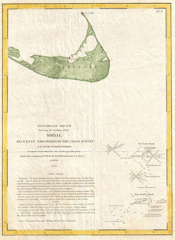
Preliminary Sketch Showing the Position of the Shoal Recently Discovered by the Coast Survey.
1846 (dated) 11.5 x 8.5 in (29.21 x 21.59 cm)
1846 (dated) 11.5 x 8.5 in (29.21 x 21.59 cm)
Description
... The history of this most dangerous and fatal shoal is startling. Situated in mid-ocean; having, in low ebbs, scarcely a foot of water; in a region proverbial for its heavy swell; rising, at times, without a moment's warning; the dread of all mariners, and the grave of thousands ....Uncommon, highly significant, and often under-appreciated, this is 1848 map is the first U.S. Coast Survey chart to depict the shoals off Nantucket. Though the unpredictable waters off Nantucket were long a nemesis to sailing vessels on the important London – New York shipping routes, they had never been properly charted. The harsh conditions, including rapid unexpected swells and frequent heavy fog, contrived to make the hydrographic survey of the hazards south of Nantucket one of the most dangerous and challenging projects of the early coast survey. The first survey party to tackle this area was lead by the indomitable Lieutenant Commanding Charles H. Davis. Starting at Old South Shoal, a known danger, Davis worked his way southward and soon discovered 'New South Shoal,' which was later renamed 'Davis Shoal' in his honor. Working seasonally, it took the Coast Survey to 1853, fully seven years, to complete the survey of the Old South Shoal and Davis' Shoal.
-William Mitchell
The outline map of Nantucket, appearing in the upper left hand quadrant, is based upon a map prepared by William Mitchell, a Nantucket local and life long friend of Bache. This outline of map of Nantucket would continue to grace the upper left corner of the U.S. Coast Survey 'Davis Shoal' sheets until the late 1850s.
Prepared by Charles H. Davis under the supervision of A. D. Bache for the 1847 edition of the Superintendent's Report.
CartographerS
The Office of the Coast Survey (1807 - present) founded in 1807 by President Thomas Jefferson and Secretary of Commerce Albert Gallatin, is the oldest scientific organization in the U.S. Federal Government. Jefferson created the "Survey of the Coast," as it was then called, in response to a need for accurate navigational charts of the new nation's coasts and harbors. The spirit of the Coast Survey was defined by its first two superintendents. The first superintendent of the Coast Survey was Swiss immigrant and West Point mathematics professor Ferdinand Hassler. Under the direction of Hassler, from 1816 to 1843, the ideological and scientific foundations for the Coast Survey were established. These included using the most advanced techniques and most sophisticated equipment as well as an unstinting attention to detail. Hassler devised a labor intensive triangulation system whereby the entire coast was divided into a series of enormous triangles. These were in turn subdivided into smaller triangulation units that were then individually surveyed. Employing this exacting technique on such a massive scale had never before been attempted. Consequently, Hassler and the Coast Survey under him developed a reputation for uncompromising dedication to the principles of accuracy and excellence. Unfortunately, despite being a masterful surveyor, Hassler was abrasive and politically unpopular, twice losing congressional funding for the Coast Survey. Nonetheless, Hassler led the Coast Survey until his death in 1843, at which time Alexander Dallas Bache, a great-grandson of Benjamin Franklin, took the helm. Bache was fully dedicated to the principles established by Hassler, but proved more politically astute and successfully lobbied Congress to liberally fund the endeavor. Under the leadership of A. D. Bache, the Coast Survey completed its most important work. Moreover, during his long tenure with the Coast Survey, from 1843 to 1865, Bache was a steadfast advocate of American science and navigation and in fact founded the American Academy of Sciences. Bache was succeeded by Benjamin Pierce who ran the Survey from 1867 to 1874. Pierce was in turn succeeded by Carlile Pollock Patterson who was Superintendent from 1874 to 1881. In 1878, under Patterson's superintendence, the U.S. Coast Survey was reorganized as the U.S. Coast and Geodetic Survey (C & GS) to accommodate topographic as well as nautical surveys. Today the Coast Survey is part of the National Oceanic and Atmospheric Administration or NOAA as the National Geodetic Survey. More by this mapmaker...
William Mitchell (December 20, 1791 - April 19, 1868) was an American born Quaker, astronomer and surveyor based in Nantucket, Massachusetts. Mitchell attended various private schools on Nantucket Island and for a time planned to study at Harvard. However, for unknown reasons, possibly fiscal limitations relating to the War of 1812, these plans never materialized. Ultimately, Mitchell took responsibility for his own education and made extensive studies in astronomy, surveying, and mathematics. When the U.S. Coast Survey arrived on the island in 1847, Mitchell became fast friends with A. D. Bache, Superintendent of the Survey. The two became lifelong friends and Mitchell's comments and research appears in several editions of the Superintendent's annual Report. Mitchell's most important cartographic work is his 1838 map of Nantucket. This map, which includes Tuckernuck Island, eventually made its way into the U. S. Coast survey where it was a fixture for nearly 10 years. Mitchell was survived by a son, Henry Mitchell, and daughter, Maria Mitchell. Henry became a prominent Hydrographer with the U.S. Coast Survey and is responsible for many important maps and charts. Maria Mitchell, following in her father's footsteps, became an astronomer of international acclaim, eclipsing the rest of her family in prominence. She was eventually accepted an appointment as Professor of Astronomy at Vassar College, in Poughkeepsie, NY. It was here, under the care of his ever-devoted daughter that William Mitchell passed away in 1868. Learn More...
Source
Report of the Superintendant of the U.S. Coast Survey, (1847 edition).
Condition
Very good. Original folds, as issued. Minor crease lower left quadrant.
References
Maryland State Archives, MSA SC 1399-1-604. Bache, A. D., Report of the Superintendent of the U.S. Coast Survey 1845, p. 43.