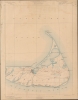
1887 U. S. Geological Survey Map of Nantucket, Massachusetts (2 Sheets)
NantucketMuskeget-usgs-1887$600.00


Title
Massachusetts. Nantucket sheet / Massachusetts. Muskeget sheet.
1887 (dated) 20 x 29 in (50.8 x 73.66 cm) 1 : 62500
1887 (dated) 20 x 29 in (50.8 x 73.66 cm) 1 : 62500
Description
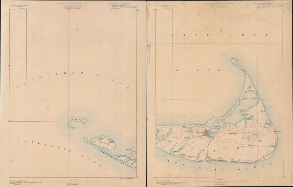
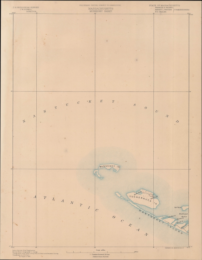
A two-sheet 1887 U.S. Geological Survey map of Nantucket and nearby islands. These sheets constitute the first 'preliminary edition' of this map, which continued to be the standard map of Nantucket by the Geological Survey until 1919.
Hard to believe given its current status as a highly desirable tourist destination, Nantucket was suffering from hard times when this map was produced. The whaling industry that had been the mainstay of the island's economy in the early 19th century had died out and the harbor had silted up. But these difficulties were a blessing in disguise, as the island's hardy historic structures were not bulldozed for modern development, preserving them for posterity.
A Closer Look
The right covers most of Nantucket Island, including the town of Nantucket, from Great Neck to the Atlantic. It identifies topographical features such as the Shawkemo Hills, Alter Rock Hills, Folgers Hill, Gibbs Pond, Mioxes Pond, Miacomet Pond, and the Head of Hummunock. It also notes the various roads traversing the islands and the narrow-gauge Nantucket Railroad between the town of Nantucket and Siasconsett. The Sankaty Head Lighthouse, Nantucket Cliff Beacons, Brant Point Lighthouse, and Nantucket Lighthouse at Great Point are all labeled. The left sheet includes Muskeget Island, Tuckernuck Island, and the western parts of Nantucket. Together, the map offers copious topographical detail and some submarine detail, as well as towns, roads, and some individual buildings.Hard to believe given its current status as a highly desirable tourist destination, Nantucket was suffering from hard times when this map was produced. The whaling industry that had been the mainstay of the island's economy in the early 19th century had died out and the harbor had silted up. But these difficulties were a blessing in disguise, as the island's hardy historic structures were not bulldozed for modern development, preserving them for posterity.
Publication History and Census
Surveyed in 1887 and prepared by Henry Gannett, Marcus Baker, and E. B. Clark, this 'preliminary edition' map of Nantucket are among the most sought after topographical maps produced by the U.S. Geological Survey. The David Rumsey Historical Map Collection includes the map, also marked 'preliminary edition', as it appeared as sheets 49 and 53 in the 1890 Atlas of Massachusetts from topographical surveys (also previously sold by us). The present sheets, however, are unnumbered and presumably predate the atlas.Cartographer
The Office of the Coast Survey (later the U.S. Geodetic Survey) (1807 - present), founded in 1807 by President Thomas Jefferson and Secretary of Commerce Albert Gallatin, is the oldest scientific organization in the U.S. Federal Government. Jefferson created the "Survey of the Coast," as it was then called, in response to a need for accurate navigational charts of the new nation's coasts and harbors. The first superintendent of the Coast Survey was Swiss immigrant and West Point mathematics professor Ferdinand Hassler. Under the direction of Hassler, from 1816 to 1843, the ideological and scientific foundations for the Coast Survey were established. Hassler, and the Coast Survey under him developed a reputation for uncompromising dedication to the principles of accuracy and excellence. Hassler lead the Coast Survey until his death in 1843, at which time Alexander Dallas Bache, a great-grandson of Benjamin Franklin, took the helm. Under the leadership A. D. Bache, the Coast Survey did most of its most important work. During his Superintendence, from 1843 to 1865, Bache was steadfast advocate of American science and navigation and in fact founded the American Academy of Sciences. Bache was succeeded by Benjamin Pierce who ran the Survey from 1867 to 1874. Pierce was in turn succeeded by Carlile Pollock Patterson who was Superintendent from 1874 to 1881. In 1878, under Patterson's superintendence, the U.S. Coast Survey was reorganized as the U.S. Coast and Geodetic Survey (C & GS or USGS) to accommodate topographic as well as nautical surveys. Today the Coast Survey is part of the National Oceanic and Atmospheric Administration or NOAA. More by this mapmaker...
Condition
Good. Soiling and toning.
References
Rumsey 2883.054, 2883.050 (1890 editions).