1881 Stoner View of Nantucket Town, Massachusetts
NantucketView-stoner-1881$16,000.00


Title
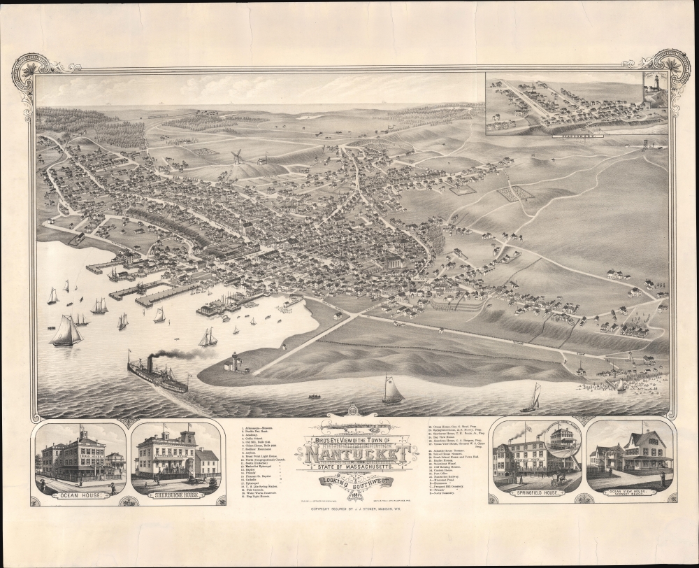
Bird's Eye View of the Town of Nantucket in the State of Massachusetts. Looking Southwest.
1881 (dated) 24 x 29.5 in (60.96 x 74.93 cm)
1881 (dated) 24 x 29.5 in (60.96 x 74.93 cm)
Description
An impressive 1881 bird's-eye view map of the town of Nantucket, Massachusetts, by Joseph Stoner. This is considered the largest and best bird's-eye view of Nantucket. It emerged as the city was transitioning from a maritime whaling hub to a resort economy.
Nantucket Harbor fills the foreground, with pleasure-boats far exceeding commercial vessels. The sidewheel steamer 'River Queen' prominently navigates into the harbor. The 'River Queen' was then being run by the New Bedford, Martha's Vineyard, and Nantucket Steamboat Company, but in this case, it may reference use of the steamer to visit Nantucket by Ulysses S. Grant in 1874. In the upper right corner are smaller inset views of Siasconset and the Sankaty Head Light House.
City views were being produced in the United States as early as the 1830s, but the genre exploded after the American Civil War (1861 - 1865). Bridging the gap between maps and pictures, most 19th century American bird's-eye views presented cities to the public from highpoints. Some were imagined, but others were drawn from hot-air balloons or nearby hills. The presentation, combining high elevation, commercial interest, and new printing technology created a uniquely American artform, as described by historian Donald Karshan,
A Closer Look
The view looks southwest on Nantucket, showcasing the bustling harbor, rolling hills, and the sea beyond. Some 36 buildings are identified according to the numbered key at the base. These include eights 'Houses' (early large guest houses or hotels). Four of these, Ocean House, Sherburne House, Springfield House, and Ocean View House, Sconset Beach, are illustrated - likely paid placements. In addition, there are various churches, municipal structures, schools, and points of interest, such as the 'Old Mill, Built 1745' and 'Oldest House, Built 1686'.Nantucket Harbor fills the foreground, with pleasure-boats far exceeding commercial vessels. The sidewheel steamer 'River Queen' prominently navigates into the harbor. The 'River Queen' was then being run by the New Bedford, Martha's Vineyard, and Nantucket Steamboat Company, but in this case, it may reference use of the steamer to visit Nantucket by Ulysses S. Grant in 1874. In the upper right corner are smaller inset views of Siasconset and the Sankaty Head Light House.
Historical Context
In 1881, Nantucket, an island off the coast of Massachusetts, was past its prime as a leading global whaling hub, but the town was fast pivoting towards tourism. The island's picturesque landscapes, historic homes, and seaside charm attracted visitors, leading to the establishment of hotels, guest houses, and an infrastructure to support a burgeoning tourist industry. This transformation marked the beginning of Nantucket's emergence as a beloved summer destination for the elite, many of whom constructed grand residences in town and elsewhere on the island.American Bird's-Eye City Views
The Bird's-Eye view industry emerged in the United States in the middle part of the 19th century and coincided with the commercial development of lithographic printing. Before the rise of lithography, the ability to own and display artwork in the home was largely limited to the extremely wealthy, but the advent of lithographic printing made it possible for everyone to own visually striking artwork. A robust trade developed in portraits of political leaders, allegorical and religious images, and city views.City views were being produced in the United States as early as the 1830s, but the genre exploded after the American Civil War (1861 - 1865). Bridging the gap between maps and pictures, most 19th century American bird's-eye views presented cities to the public from highpoints. Some were imagined, but others were drawn from hot-air balloons or nearby hills. The presentation, combining high elevation, commercial interest, and new printing technology created a uniquely American artform, as described by historian Donald Karshan,
Some print connoisseurs believe that it was only with the advent of the full-blown city-view lithograph that American printmaking reached its first plateau of originality, making a historical contribution to the graphic arts. They cite the differences between the European city-view prints and the expansive American version that reflects a new land and a new attitude toward the land.The vogue for bird's-eye city views lasted from about 1845 to 1920, during which period some 2,400 cities were thus portrayed, some multiple times. Although views were produced in many urban centers, the nexus of view production in the United States was Milwaukee, Wisconsin. The major American viewmakers were Stoner, Wellge, Bailey, Fowler, Hill Ruger, Koch, Burleigh, Norris, and Morse, among others.
Publication History and Census
This map was published in 1881 by Joseph Stoner of Madison, Wisconsin, and printed by stone lithograph in Milwaukee, Wisconsin, by Beck and Pauli. Reps locates examples at the Connecticut Historical Society, Library of Congress, and Mariners’ Museum in Newport News, Virginia. OCLC further identifies holdings at the Massachusetts State Library, Pennsylvania State University, and the University of Connecticut, and the University of Illinois. We are also aware of an example at the Nantucket Historical Society. Scarce on the market.CartographerS
Joseph John Stoner (December 21, 1829 - May 1917) was a Madison, Wisconsin based publisher of bird's-eye city views active in the late 19th and early 20th centuries. Stoner was born in Highspire, Pennsylvania and apprenticed as a carver of ornamental chairs before turning to publishing. He partnered with the bookseller Ephraim T. Kellogg of Madison, Wisconsin, for whom he was a traveling agent. His career in views began around 1867 when he met and befriended the bird's-eye view artist Albert Ruger, who was sketching Madison that year. Ruger and Stoner partnered and began publishing city views under the imprint 'Ruger & Stoner.' The partners traveled extensively through the Midwest publishing some 11 city views under their joint imprint - although there may be as many as 62 others unattributed. The partnership partially dissolved in 1872 although they continued to work together on a contractual basis. Stoner subsequently traveled even more extensively, hiring young artists to sketch city views in such wide ranging destinations as Texas, Maine, and Oregon, among others. He produced a total of some 314 views with various artists including: Albert Ruger, Herman Brosius, Thaddeus M. Fowler, Augustus Koch, Albert F. Poole, Henry Wellge, Joseph Warner, and Camille N. Drie (Dry). Stoner died in Berkeley, California in 1917. More by this mapmaker...
Beck and Pauli (fl. c. 1878 – 1889) was a Milwaukee, Wisconsin based lithography firm founded in 1878 by Clemens J. Pauli and Adam Beck. The firm published hundreds of lithograph city views for many of the most prominent viewmakers of the period, including Lucien Rinaldo Burleigh, J. J. Stoner, Henry Wellge, Pauli himself, and others. The company was most active in the mid-1880 until about 1889, when the partners went separate ways and closed the company. Learn More...
Condition
Good. Expertly restored to repair and stabilize several large closed tears.
References
Reps, John, Views and Viewmakers of Urban America (University of Missouri, Columbia, 1984), #1549. Boston Public Library, Leventhal, G3764.N18A3 1881 .S76. OCLC 5451052.