This item has been sold, but you can get on the Waitlist to be notified if another example becomes available, or purchase a digital scan.
1902 Philip Map of the Colony of Natal, South Africa, Second Boer War
Natal-philip-1902$175.00

Title
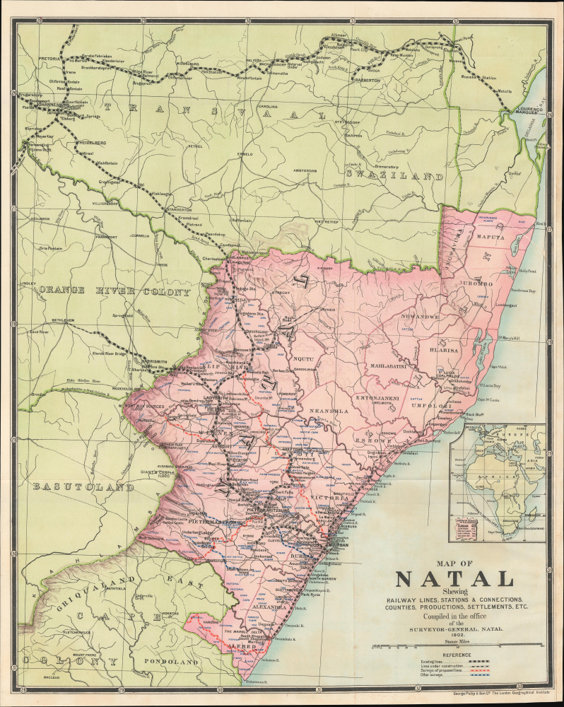
Map of Natal shewing railway lines, stations and connections, counties, productions, settlements, etc.
1902 (dated) 20.25 x 16.5 in (51.435 x 41.91 cm) 1 : 1290000
1902 (dated) 20.25 x 16.5 in (51.435 x 41.91 cm) 1 : 1290000
Description
This is a 1902 George Philip and Son map of the Colony of Natal, in Southern Africa, produced near the end of the Second Boer War (1899 - 1902). As Natal was the main theater in the first phase of the conflict, it would have been of considerable interest to a riveted British public.
After negotiations to address the tensions failed, the Boers mobilized their militias, successfully winning several important battles and seizing several cities. Although a ragtag force at first glance, the Boers had the advantage of knowing the terrain, being experienced hunters and horsemen, and having a strong motivation to resist, emboldened by their victory in the First Boer War (1880 - 1881) 20 years prior. Early British counterattacks failed miserably, humbling the great imperial power. Reinforcements flooded into South Africa, bringing more than 400,000 men from far-flung colonies, and the British replaced their commander with the capable Lord Roberts (1832 - 1914).
Having regrouped, the British under Roberts were able to relieve the sieges and win a string of battles in February 1900. The Boers were heavily outnumbered, and in a matter of a few months, the British seized control of both the Orange Free State and the Transvaal. Still, fighting continued in the form of guerrilla attacks, countered with sometimes brutal scorched earth tactics and mass internments, until a negotiated settlement was reached in 1902. The war gained international attention and was notable for presaging later developments in warfare, such as the use of barbed wire and machine guns, as well as concentration camps for civilians.
A Closer Look
Natal is presented along with nearby territories, with administrative divisions, cities and towns, local economic goods (ostriches, cattle, sugar, tea, etc.), waterways, mountains, and roads noted. The greatest attention, however, is paid to railways, including existing lines, those under construction, and those that have been surveyed. Natal and nearby areas were home to an impressively dense railway network at the time, which was prompted by an imperial tussle between Britain and Portugal for influence in southern Africa. The railway linking Pretoria to the port of Lourenço Marques (Maputo) was envisioned as early as 1870 as a means for the Boer Republics to resist growing British influence in the interior of southern Africa. For their part, the British invested heavily to build railway lines from Durban into the coal fields of North Natal, which saw a 'coal rush' in the early 1880s. This railway building spree was given added impetus by the same events that ultimately caused the Second Boer War, namely the Witwatersrand Gold Rush. When the war came, Natal was one of its main battlegrounds. Several cities were besieged for months - including Ladysmith (now uMnambithi) seen here and British mining colonies within Boer territory - as the Boers were too small in number to seize the cities but capable enough to repel British relief efforts.The Second Boer War
Also known as the Boer War, Anglo-Boer War, or South African War, the Second Boer War (October 11, 1899 - May 31, 1902) was a conflict fought between the British Empire and the independent Boer states Republic of Transvaal / South African Republic (Zuid-Afrikaansche Republiek) and the Orange Free State. Although tensions in southern Africa between British and Boer had been fermenting for nearly a century, the Second Boer War was set off by the discovery of the 1886 Witwatersrand Gold Reef near modern-day Johannesburg. British and other foreign fortune hunters, uitlanders as they were known among the Boers, poured into the region, threatening Boer sovereignty.After negotiations to address the tensions failed, the Boers mobilized their militias, successfully winning several important battles and seizing several cities. Although a ragtag force at first glance, the Boers had the advantage of knowing the terrain, being experienced hunters and horsemen, and having a strong motivation to resist, emboldened by their victory in the First Boer War (1880 - 1881) 20 years prior. Early British counterattacks failed miserably, humbling the great imperial power. Reinforcements flooded into South Africa, bringing more than 400,000 men from far-flung colonies, and the British replaced their commander with the capable Lord Roberts (1832 - 1914).
Having regrouped, the British under Roberts were able to relieve the sieges and win a string of battles in February 1900. The Boers were heavily outnumbered, and in a matter of a few months, the British seized control of both the Orange Free State and the Transvaal. Still, fighting continued in the form of guerrilla attacks, countered with sometimes brutal scorched earth tactics and mass internments, until a negotiated settlement was reached in 1902. The war gained international attention and was notable for presaging later developments in warfare, such as the use of barbed wire and machine guns, as well as concentration camps for civilians.
Publication History and Census
This map was prepared by George Philip and Son in 1902 and appeared in the 1903 book Natal: An Illustrated Official Railway Guide and Handbook of General Information, compiled by C. W. Francis Harrison. The map is not independently cataloged with any institution and has no known market history, while the entire book is held by roughly 15 institutions.Cartographer
George Philip (1800 - 1882) was a map publisher and cartographer active in the mid to late-19th century. Philip was born into a Calvinst family in Huntly, Aberdeenshire, Scotland. Around 1819 he apprenticed himself to William Grapel, a Liverpool printer and bookseller. Fifteen years later, in 1834, Philip founded his own Liverpool book and map firm. Philip's earliest cartographic ventures were mostly educational material issued in tandem with John Bartholomew Sr., August Petermann, and William Hughes. In 1848, Philip admitted his son, George Philip Jr. (1823 - 1902) into the firm, renaming it George Philip and Son Ltd. George Philip Jr. ran the firm until his death in 1902, by which time it had developed into a major publishing concern. His successors established the London Geographical Institute, a factory where they embraced modern printing techniques to produce thousands of economical and high quality maps. In April 1988, George Philip & Son was acquired by Octopus Publishing, a branch of Reed International. Nonetheless, today the firm trades and publishes to this day as George Philip and Son. More by this mapmaker...
Source
Harrison, C. W., Natal : an illustrated official railway guide and handbook of general information, (London: Payne Jennings) 1903.
Condition
Good. Small tear along right margin professionally repaired. Right margin extended. Light wear along original fold lines.
References
Entire book - OCLC 229920585, 65679834. National Library of Australia Bib ID: 8124103. University of Cape Town Pamphlet Collection BAP 916.83 HAR.