This item has been sold, but you can get on the Waitlist to be notified if another example becomes available, or purchase a digital scan.
1944 Navy Education Services Map of Southeast Asia
NavWar2SEAsia-usn-1944$500.00

Title
NavWarMap No. 2 The South China Sea Area.
1944 (dated) 39.5 x 58.5 in (100.33 x 148.59 cm)
1944 (dated) 39.5 x 58.5 in (100.33 x 148.59 cm)
Description
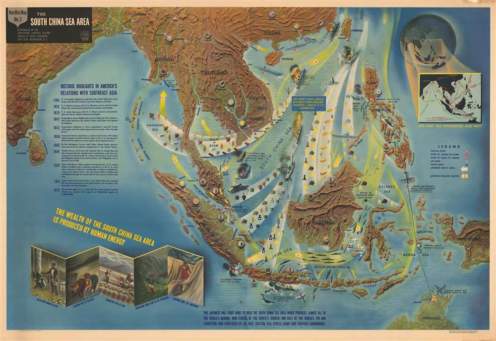
This is a 1944 Navy Education Services pictorial map of Southeast Asia. Depicting the region from India to the Pacific Ocean and from China to Java, New Guinea and northern Australia, this NavWarMap provides a visually enthralling overview of the beginning of World War II in Southeast Asia.
The beginning of World War II in the Pacific
A part of the world rich in natural resources, Southeast Asia was a target ripe for invasion by the Imperial Japanese. Per the map, 'the South China Sea Area…produces almost all of the world's quinine; nine-tenths of the world's rubber; one-half of the world's tin and tungsten; and surpluses of oil, rice, cotton, tea, spices, hemp, and tropical hardwoods.' One of the major difficulties faced by the Japanese during World War II was the nearly complete lack of natural resources on their home islands. In order to prosecute the war, which the Imperial Japanese believed was their right, these resources were a necessity. Japanese forces began attacks in the region on December 8, 1941, the same day as the surprise attack on Pearl Harbor. Quick, systematic victories followed, mostly because British and American forces in Southeast Asia underestimated the capability and the zeal of their enemy. Until the beginning of the Guadalcanal Campaign in the Solomon Islands in August 1942, the Japanese military scored victory after victory in Southeast Asia and stood nearly unopposed.A Closer Look at the Map Itself
The progression of Japanese troops throughout the region is easily traced, with yellow arrows indicating routes of the Japanese advance, with white arrows illustrating which resources they extracted from the territories they conquered. Specific events, such as the fall of Manila, Corregidor, and Bataan in the Philippines, and the sinking of the H.M.S. Repulse and the H.M.S. Prince of Wales are illustrated, labeled, and dated. General Douglas MacArthur's escape from the fortress on Corregidor is highlighted, with the map illustrating his route to Darwin, Australia in order to continue to command Allied troops in the Southwest Pacific after the fall of the Philippines. Airfields and naval bases are indicated throughout the region, along with capitals and other cities. An inset map of the region on the upper right provides both air and sea distances between cities in the region, allowing the viewer to better comprehend just how much area of the world this theater covered. 'Historic highlights' of America's involvement in Asia are provided along the left, along with sketches of indigenous people gathering 'the wealth of the South China Sea Area'. Also, it is important to remember that this map, and the others in the NavWarMap series, were created both to inform, but also to motivate, Allied soldiers, sailors, and airmen.The NavWarMap Series
These NavWarMaps are part of a series of six maps that was created by the Bureau of Naval Personnel, which was part of the Navy Department. These include:- NavWarMap No. 1 The Mediterranean
- NavWarMap No. 2 The South China Sea Area
- NavWarMap No. 3 World War II in the North Sea Area
- NavWarMap No. 4 The North Pacific Area
- NavWarMap No. 5 Southwest Pacific
- NavWarMap No. 6 We Fight a Global War
Publication History and Census
This map was created within the Bureau of Naval Personnel, most likely by the training division, and distributed by the Educational Services Section. It is important to remember that this map, and the others in the NavWarMap series, were created both to inform, but also to motivate, Allied soldier, sailors, and airmen. Usually, when we encounter examples of maps from this series, they have been folded. Here, surprisingly, this example has never been folded, giving it a pristine appearance that most from this series do not have. No OCLC references exist for the individual maps. One OCLC entry catalogues nine institutions that possess the entire set of six in their collection, which are: Franklin and Marshall College, the Ohio State University, the University of Michigan, the University of Wisconsin, the Wisconsin Historical Society, the University of Florida, Idaho State University, the National Library of Australia, and Monash University in Clayton, Australia.Condition
Good. No fold lines. Closed margin tears professionally repaired on verso. Area of infill in upper right margin. Blank on verso.
References
OCLC 53073135.