This item has been sold, but you can get on the Waitlist to be notified if another example becomes available, or purchase a digital scan.
1943 Owens and Minneapolis Morning Tribune Map of Fortress Europe
NaziOffensiveDefensive-owens-1943$112.50

Title
Nazis Being Forced From Offensive to Defensive.
1943 (dated) 21.75 x 15.5 in (55.245 x 39.37 cm)
1943 (dated) 21.75 x 15.5 in (55.245 x 39.37 cm)
Description
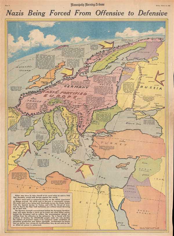
This is a Friday, March 19, 1943 Charles Hamilton Owens and Minneapolis Morning Tribune map of 'Fortress Europe'. The map depicts the region from Spain and Algeria to Scandinavia, Russia, Turkey, and the Middle East and from the Arctic Ocean to North Africa. With victory in North Africa still two months away, here Owens turns his eye toward the next major problem confronting the Allies in the fight to defeat the Axis powers in Europe: how to invade a fortified continent. With fortifications built along essentially the entire perimeter of Nazi occupied Europe, no clear answer to that conundrum appeared to present itself. In March 1943, the Allied powers launched a misinformation campaign, aided by false intelligence papers which fell into the hands of a German agent, that the next major invasion would come in the Balkans. Even so, there were at least four other possible invasion points that Hitler and other Nazi leaders had to concern themselves with, meaning that they were unable to concentrate their forces in any one location, particularly on the Eastern Front.
As Owens notes in several captions on this map, the Axis also had to contend with and Allied blockade (which may be a little strong, considering the strength of German U-boats in the Atlantic). However, with war raging in North Africa, provisions from that part of the world were no longer readily available to a 'besieged' Europe. Privations and shortages were a major factor in ending World War I, a fact to which Owens alludes here, and perhaps is implicitly stating could be a factor in the current war as well. In the final sentence of the text box located in the lower left corner, Owens states, 'no matter how strong his [Hitler's] fortifications they do not exist as far as Allied air power is concerned.' Even with the horrors and violence unleashed from the sky by Allied bombers and their aircrews, bombing a city, in the end, does not liberate it. Even if the fortifications 'will make Europe a hard nut to crack', nothing could be done to avoid an invasion.
When Charles Hamilton Owens drew this map, he was doubtless inspired by the work of Richard Edes Harrison, an American illustrator and cartographer who, working for Fortune magazine, pioneered a new style of representing the world for WWII era propaganda maps. Edes developed the convention of using spherical perspective with an exaggerated vertical dimension, as on the present map, to illustrate part of the world as part of a greater global situation. This map was drawn by Charles Hamilton Owens and published in the Minneapolis Morning Tribune on Friday, March 19, 1943.
CartographerS
Charles Hamilton Owens (Feb 16, 1881 - March 3, 1958) was an American painter and illustrator and staff illustrator for the Los Angeles Times. Born in San Francisco, he had a passion for drawing from a young age. After landing a job as a messenger for The San Francisco Examiner, Owens began being taught his trade by the newspaper's illustrators. Although it is unclear exactly where Owens started his career as a newspaper staff artist, his reputation was launched by his detailed sketches of the 1906 San Francisco earthquake and fire for a New York paper, using only wire reports and his knowledge of the city. By 1910, Owens was working for the Los Angeles Examiner. Even at this point in his career, Owens was known for experimenting with new forms of illustration, fusing drawings of events with photographs. Owens's map of the Titanic disaster used a high oblique perspective, 'capturing the earth's sphericity and showing the polar regions on a curving horizon.' By the 1920s, Owens reputation as an artist in Los Angeles had grown beyond the realm of journalism. He had a studio and received commissions for landscapes and had exhibited watercolors of California and Hawaii landscapes. Thus, when Owens began creating his war series in April/May 1942, he had all the necessary skills to create visually striking works. The Los Angeles Times began a series of maps for its readers, which were full-page inserts that would appear every Monday and Saturday. Owens's maps would be included in the Monday issues, and a Rand McNally map would be included on Saturdays. The Rand McNally maps, however, were discontinued on June 27, 1942, but Owens's maps continued to be printed. His last war map was published on September 10, 1945, a little over a week after the Japanese surrender. Owens died in Los Angeles on March 3, 1958. More by this mapmaker...
The Minneapolis Tribune (1867 - present) was founded by Colonel William S. King, William D. Washburn, and Dorilus Morrison and the first issue was published on May 25, 1867. In 1941, the Cowles family of Des Moines, Iowa bought the Tribune and merged it with their other holdings in Minneapolis, giving the Cowles family ownership of all the city's major newspapers. The Tribune became the city's morning newspaper, and the Star-Journal was the evening newspaper. The two published a joint Sunday edition. The newspaper is still published today, under the name Star Tribune. Learn More...
Condition
Very good. Newsprint. Even overall toning. Closed minor margin tears professionally repaired on verso. Text on verso.