This item has been sold, but you can get on the Waitlist to be notified if another example becomes available, or purchase a digital scan.
1580 Ortelius Map of Southern Italy: Naples, Calabria
NeapolitaniItaly-ortelius-1580$625.00

Title
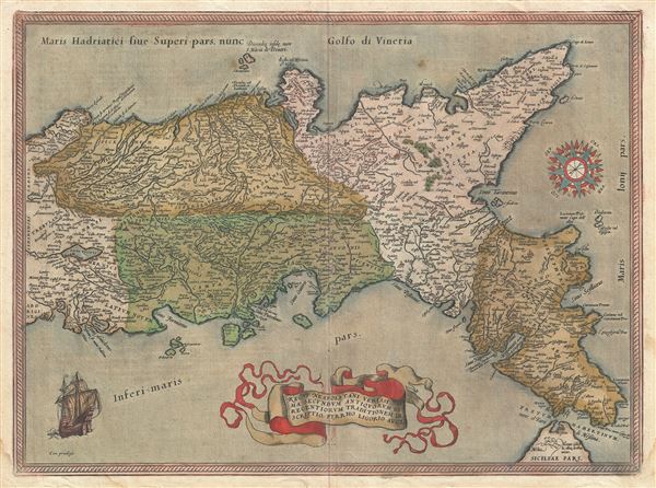
Regni Neapolitani Verissima Secundum Antiquorum et Recentiorum Traditionem Descriptio, Pyrrho Ligorio Acut.
1580 (undated) 15 x 20 in (38.1 x 50.8 cm) 1 : 1250000
1580 (undated) 15 x 20 in (38.1 x 50.8 cm) 1 : 1250000
Description
A very beautiful old color example of Abraham Ortelius's 1580 map of southern Italy. Oriented to the east, this map covers Italy from central Italy to northern Sicily, and from the Adriatic Sea to the Tyrrhenian Sea. The map identifies countless cities and towns as well as major rivers with mountains topography and forests rendered in profile. A sailing ship decorates the lower left corner and an elaborate compass rose appears in the upper right quadrant. The title, at bottom center, is displayd in an elaborate flag floating above the Tyrrhenian Sea. Cartographically Ortelius derived this map from an earlier plan laid down by Pirro Ligorio (c. 1510 - October 30, 1583), a well-respected Italian architect (St. Peter's Basilica), painter, cartographer and antiquarian. Ortelius originally drew this map in 1570 after which it was issued in numerous subsequent editions and two states. The present example is the 2nd state issued in 1580 for the German language edition of the Theatrum Orbis Terrarum. There were 350 maps printed for this edition and the total run for this map is 8175 maps - low for an Ortelius map. How many may have survived the subsequent 400 years or so we cannot guess.
Cartographer
Abraham Ortelius (April 14, 1527 - June 28, 1598) also known as Ortels, was a cartographer, geographer, and cosmographer of Brabant, active in Antwerp. He was the creator of the first modern atlas, Theatrum Orbis Terrarum and is a seminal figure in the history of cartography. Along with Gerard Mercator and Gemma Frisius, he was a founder of the Netherlandish school of cartography. His connections with Spain - culminating in his 1575 appointment as Royal Cartographer to King Phillip II of Spain - gave him unmatched access to Spanish geographical knowledge during a crucial period of the Age of Discovery. Ortelius was born in 1527 in Antwerp. In 1547 he entered the Antwerp Guild of Saint Luke as an illuminator of maps. He began trading in books, prints, and maps, traveling regularly to the Frankfurt book and print fair, where in 1554 he met Mercator. He accompanied Mercator on journeys throughout France in 1560 and it was at this time, under Mercator's influence, that he appears to have chosen his career as a scientific geographer. His first published geographic work appeared in 1564, an eight-sheet cordiform world map. A handful of other maps preceded the 1570 publication of the first edition of the Theatrum Orbis Terrarum, which would prove to be his life work. Appearing with but 53 maps in its first edition, Ortelius' work expanded with new maps added regularly. By 1592, it had 134 maps. Many of Ortelius' maps remained the standard for nearly a century. He traveled extensively, but his genius was as a compiler, locating the best informed maps on which to base his own. His contacts throughout Europe and extending even (via the Portuguese) to the Far East were formidable. Moreover, many of his maps were based on his own scholarship, particularly his historical works. His theories of geography were particularly ahead of his time with respect to the notion of continental drift, the possibility of which he mused on as early as 1596, and which would be proven correct centuries later.
In a sense his greatest achievement was his successful navigation of the religious and political violence endemic to his city throughout his adult life: The Dutch Revolt, or Eighty Years' War (1568 - 1648), fully embroiled Antwerp. Although outwardly and officially recognized as Catholic (Arias Montanus vouched for Ortelius' Catholic orthodoxy prior to his appointment as Royal Geographer), Ortelius was able to separate himself from the religious furor which characterized the war in the low countries. Ortelius showed a glimpse of himself in a letter to a friend, regarding humanist Justus Lipsius: 'I do not know whether he is an adherent of the Pope or a Calvinist, but if he has ears to hear, he will neither be one nor the other, for sins are committed on both sides'. Ortelius' own explorations of Biblical history in his maps, and the Christogram contained in his own motto, suggest him to be a religious man, but his abjuration of political religious authorities mark him as an individualist. His tombstone at St Michael's Præmonstratensian Abbey in Antwerp bears the inscription, Quietis cultor sine lite, uxore, prole. ('served quietly, without accusation, wife, and offspring.') More by this mapmaker...
Source
Ortelius A., Theatrum Orbis Terrarum, (Antwerp), German Edition, 1580.
Condition
Very good. German text on verso. Even overall toning. Original centerfold.
References
Ort 139 (Koeman/Meurer: 37, Karrow: 1/50, vdKrogt AN: 7400:31), 1580/1589G68.