1954 Clarke Pictorial Map of Nebraska Celebrating the Nebraska Territory Centennial
NebraskaTerrCentennial-clarke-1954$650.00

Title
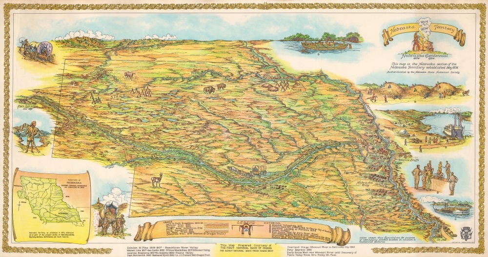
Nebraska Territory Nebraska Centennial 1854 - 1954.
1954 (dated) 18.125 x 34.5 in (46.0375 x 87.63 cm)
1954 (dated) 18.125 x 34.5 in (46.0375 x 87.63 cm)
Description
This is Walter F. Clarke's 1954 pictorial map of the Nebraska Territory created to celebrate the joint centennial of Nebraska Territory and the city of Omaha. The map illustrates Nebraska as it appeared in 1854, with coverage extending well outside modern-day Nebraska's borders. It reaches north to the Black Hills in modern-day South Dakota and west to Fort Laramie in modern-day Wyoming.
A Closer Look
Pictorial buildings mark Omaha City, Nebraska City, Plattsmouth, De Soto, Fort Atkinson, and Tekamah along the Missouri River. Cities and towns founded after 1854, including Lincoln, Broken Bow, North Platte, Alliance, and Scottsbluff, appear in parentheses. Fort Kearny appears along the Platte River, across from an illustration of a covered wagon team. Sioux, Pawnee, and Ponca settlements are also identified. Nebraska landmarks are named throughout, including Chimney Rock, Scott's Bluff, and Ash Hollow. A key along the bottom details the Lewis and Clark Expedition, Mallet Brothers Expedition, the Mormon Trail, the Oregon Trail, and the California Trail. Five vignettes along the right illustrate the steamer Yellowstone, the donation to charter the city of Omaha, Mormons landing at Florence in 1854, Indian lodges, and a keel boat used for river travel.Publication History and Census
This map was created by Walter F. Clarke, authenticated by Dr. James C. Olsen (Superintendent of the Nebraska State Historical Society), printed by Epson Lithography in Omaha, and published by the First National Bank of Omaha. Clarke presented the completed map to the Nebraska State Historical Society Committee of the Omaha Centennial on Monday, April 19, 1954. We note two cataloged examples: Library of Congress and the David Rumsey Map Collection. It was published in two formats: the present large format edition and a reduced variant.Condition
Very good. Some creasing.
References
Rumsey 9766.000. OCLC 979984761.