1934 Survey of India Map of Nepal (1st modern map of Nepal)
Nepal-surveyofindia-1934$6,000.00

Title
Nepāl.
1934 (dated) 37.25 x 67.5 in (94.615 x 171.45 cm) 1 : 506880
1934 (dated) 37.25 x 67.5 in (94.615 x 171.45 cm) 1 : 506880
Description
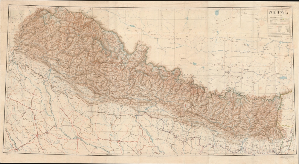
A striking 1934 Survey of India wall map of Nepal. This is the 'first edition' of the first trigonometrical survey of Nepal, completed by the all-Indian Nepal Detachment of the Survey of India at a time when Nepal was still closed to foreigners under the Rana Dynasty's isolation policy. It is a mapmaking triumph considered the world's first serious look at the interior cartography of Nepal. The map was issued in the wake of the 1934 Great Bihar-Nepal Earthquake, an 8.0 magnitude earthquake considered one of the most destructive in history.
In 1924, Maharaja Sir Chandra Shamsher Jung Bahadur Rana (1863 - 1929) requested the assistance of the Survey of India in compiling a modern trigonometrical and topographical map of the Kingdom, with the stipulation that only 'Indian Surveyors' be used, as the British were still refused admittance. The Rana fully financed the survey and supported it with military assistance. Over two years (three seasons), the team of 14 Indian surveyors and ever-growing support staff ranged throughout Nepal, conducting and compiling trigonometrical measurements at the field scale of 4 miles to the inch.
The completed survey is one of the greatest achievements of early 20th-century mapmaking. Quoting the 1927 Survey of India Report
A Closer Look
The massive map covering the totality of Nepal is presented on a polyconic projection. Nepal is meticulously detailed, with special attention given to river systems and topography, with contours set at 1000-foot intervals. The key suggests that some borders are 'undemarcated' or 'approximate,' but this may be a layover from the 1928 preliminary printing, as we note clear borders. Red printing indicates trails suitable for pack animals, with suspension bridges noted. Also noted are major mountains, including Mt. Everest, which is identified with both its English and Tibetan name, Chomolungma. (At the time, Everest did not have a Nepali name.) The surrounding areas of Tibet and India are included without topographic detail, but it is of interest that train lines markedly skirt or terminate at the Nepali border.The First Survey of Nepal (1925-1927)
In the early 1920s, Nepal remained a closed country under the autocratic and isolationist yet strongly pro-British Rana Dynasty. In December 1923, Britain and Nepal signed a 'treaty of perpetual peace and friendship,' upgrading the British resident in Kathmandu to an envoy and deepening diplomatic relations. At the same time, foreign military, business, and personal travel to and within Nepal was forbidden. As late as 1928, it was estimated that only 120 English and 10 other Europeans visited the Kathmandu Valley. Nonetheless, the Rana, whose forces fought alongside the British in several external conflicts, were keenly aware of the importance of advancing the Kingdom's bureaucracy, laws, and infrastructure.In 1924, Maharaja Sir Chandra Shamsher Jung Bahadur Rana (1863 - 1929) requested the assistance of the Survey of India in compiling a modern trigonometrical and topographical map of the Kingdom, with the stipulation that only 'Indian Surveyors' be used, as the British were still refused admittance. The Rana fully financed the survey and supported it with military assistance. Over two years (three seasons), the team of 14 Indian surveyors and ever-growing support staff ranged throughout Nepal, conducting and compiling trigonometrical measurements at the field scale of 4 miles to the inch.
The completed survey is one of the greatest achievements of early 20th-century mapmaking. Quoting the 1927 Survey of India Report
This Enlightened Act has resulted in one of the greatest single contributions to Himalayan Geography which has ever been made, by giving us for the first time accurate knowledge of the drainage and structure of 55,000 square miles of country (an area approximately equal to that of England and Wales), extending over the greatest mountains of the world, and including the highest known peak, Mount Everest, which is over 29000 feet above sea level.
Photo-zincography and Helio-zincography
Photo-zincography and helio-zincography are two very similar reprographic processes originally made famous by their use by the British Ordnance Survey. In 1859, photo-zincography was developed relatively simultaneously by John Walter Osborne in Australia and by two soldiers at the Ordnance Survey in Southampton, Captain Alexander de Courcy Scott and Lance-Corporal Rider, who were working under the command of Colonel Henry James, who immediately took credit for the innovation. Essentially, photo-zincography is a reproductive process that employs a glass photographic negative to create a carbon-positive print, which is then transferred to a zinc plate. Helio-zincography, while essentially the same process, eliminated the need for the carbon-positive print by placing the negative directly on the zinc plate. It offered several advantages. Most importantly, zinc plates are lighter and cheaper than lithographic stones, economizing the process considerably. As such, the process was embraced by various cartographic agencies that demanded mobility and economy, among them the British Ordnance Survey, the French Bureau Topographique, and many military mapping agencies.Publication History and Census
The survey was first heliozincographed in a preliminary state in 1928 (British Library, BLL01004896738), with this example being the 1934 Calcutta 'First Edition.' There are some 12 citations in OCLC, almost all of which refer to 1953 or 1967 editions. We note 1934 editions at the Library of Congress, Stanford, and the British Library; however, most bear the Delhi imprint and exhibit slight variations from this edition, the earlier Calcutta imprint. The main difference is expanded and revised imprint text. While this example is identified as the 1934 'First Edition,' the Delhi editions identify themselves as the 1934 'Second Edition,' citing the Dehradun preliminary printing in 1928 as the 'First Edition.' No market history.Cartographer
Survey of India (1767 - Present) is India's central engineering agency in charge of mapping and surveying the country. It was founded in 1767 by Major James Rennell, who took the post of first Surveyor General, with the mission to map and consolidate the territories of the British East India Company. The Survey undertook the Great Trigonometrical Survey between 1802 and 1852 in an attempt to accurately measure the Indian Subcontinent - considered one of the greatest feats of mapping of all time. It also sponsored clandestine surveys, at times disguised as Buddhist pilgrims, to infiltrate and map Tibet, then a closed country. With India's independence in 1947, the Survey was folded into the new Indian government, which it remains part of to this day. More by this mapmaker...
Condition
Very good. Laid on original linen. Some soiling, wear on old fold lines, and even toning. Three sheets, joined by publisher.
References
British Library, BLL01004896740. Library of Congress, G7760 1934.