This item has been sold, but you can get on the Waitlist to be notified if another example becomes available, or purchase a digital scan.
1869 Guillemin-Tarayre Proof-State Map of Nevada and the Comstock Lode
NevadaCalifornia-guillemintarayre-1868$1,750.00

Title
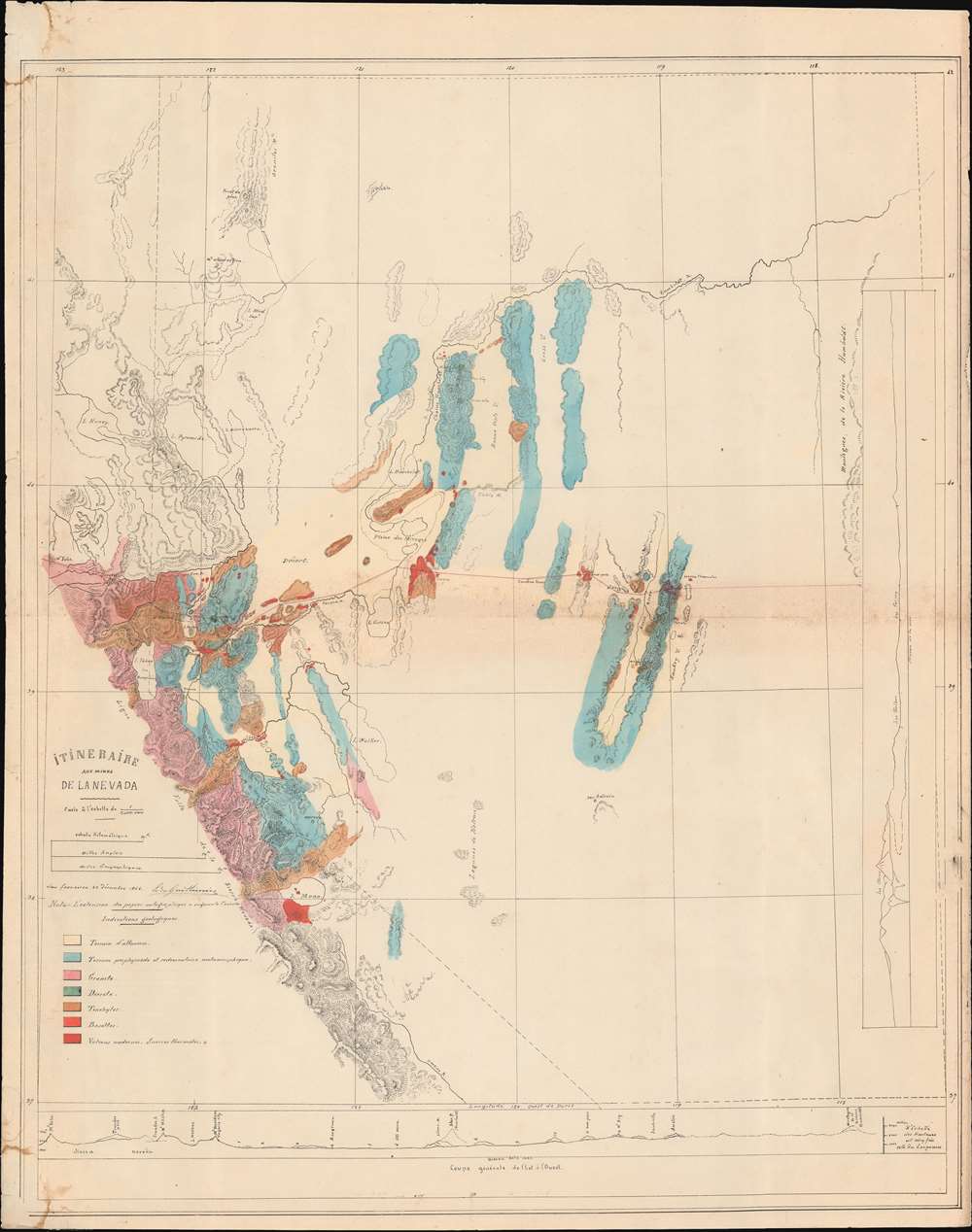
Itineraire aux Mines de La Nevada.
1868 (undated) 26.5 x 21 in (67.31 x 53.34 cm) 1 : 1000000
1868 (undated) 26.5 x 21 in (67.31 x 53.34 cm) 1 : 1000000
Description
An exceptional, likely unique discovery, this is a c. 1868 proof of the French geologist's Edmond Guillemin-Tarayre meticulous survey map of the Sierra Nevada Mountains at the height of the Nevada Silver Boom. The map focuses on epicenter of the silver boom around the Comstock Lode, Virginia City, Carson, and Dayton. It is a product of the Second French Intervention in Mexico and the accompanying Commission Scientifique.
France long held an imperial interest in Mexico, recognizing the power vacuum and political instability following the ousting of Spanish control during the Mexican War of Independence (1810 - 1821). French interest in Mexico began with expanded trade - France was Mexico's second largest trading partner by the 1830s, when the Pastry War (1838 - 1839) broke out. In the early 1840s, France sent the diplomat and spy, Eugène Duflot de Mofras (1810 - 1884), to Mexico. Among other research, he competed an impressive and detailed survey of California in anticipation of a possible French move on the North American west coast - it never happened.
Enter Napoleon III, whose interests in Mexico went far beyond trade, he wanted Empire. He used the excuse of debt repayment to launch a full-scale invasion of Mexico - the Second French Intervention (1861 - 1867) - with the plan to establish a French puppet state under Ferdinand Maximilian Hapsburg (1832 - 1867). The plan was initially successful. Well trained and equipped, the French Expeditionary Force quickly subdued Mexican forces, establishing the Second Mexican Empire.
A Proof State
While this map was commercially published in 1869, the present example is a publisher's proof, likely dating to 1868. Unlike the later commercial edition, which is refined by the engraver's precise hand, the present example, although a lithograph, bears the traits of a hand-drawn manuscript. It is almost certainly a direct copy of the original manuscript map compiled by Guillemin-Tarayre in San Francisco in December 1864, following his travels in the silver region. Such proofs were issued in small quantities of use as templates for engravers and were generally discarded as soon as the plate was fully engraved - thus such an example as here is a remarkable survivor.The Map Itself
The map details western Nevada and Eastern California, with a focus on the eastern Sierra Nevada Mountains. Lake Tahoe appears roughly at center, but the map's focus is on the Virginia City - Carson - Dayton triangle, the epicenter of the Nevada Silver region. Geological detail in bright color wash further focuses the map on areas of interest: from Virginia City - Mt. Davidson, and extends south into California as far as Mono Lake, west to the heights of the Sierra Nevada Range in California, past 'Lac Tahoe', north to the Truckee Valley and eastwards up the Humboldt River. The striking color was provides Indications géologiques, defining various types of soil and terrain - useful data for mining purposes. Two incomplete cross-sections appear along the bottom and right. The first covers from Mt. Yuba, California, in the west, to the Humboldt Mountains, in central Nevada, in the east, passing through Mount Davidson, the epicenter of the 'Comstock Lode'. The second cross-section, running along the right, covers from Lake Mono, California, north to just past Lake Carson, Nevada.Background - The Second French Intervention in Mexico
Napoleon III (1808 - 1873) had a lot to live up to. His namesake, the Emperor Napoleon Boneparte (1769 - 1821), conquered Europe, was considered one of the most brilliant military strategists of all time, redefined French law, and launched some of the most successful scientific missions ever undertaken. As President of the Second Republic from 1848, and from 1851 Emperor of France, he recognized that a European war of conquest such as Napoleon I accomplished, was out of the question. He instead focused overseas, expanding the French colonial empire, and making the French merchant navy the worlds' second largest (after Britain).France long held an imperial interest in Mexico, recognizing the power vacuum and political instability following the ousting of Spanish control during the Mexican War of Independence (1810 - 1821). French interest in Mexico began with expanded trade - France was Mexico's second largest trading partner by the 1830s, when the Pastry War (1838 - 1839) broke out. In the early 1840s, France sent the diplomat and spy, Eugène Duflot de Mofras (1810 - 1884), to Mexico. Among other research, he competed an impressive and detailed survey of California in anticipation of a possible French move on the North American west coast - it never happened.
Enter Napoleon III, whose interests in Mexico went far beyond trade, he wanted Empire. He used the excuse of debt repayment to launch a full-scale invasion of Mexico - the Second French Intervention (1861 - 1867) - with the plan to establish a French puppet state under Ferdinand Maximilian Hapsburg (1832 - 1867). The plan was initially successful. Well trained and equipped, the French Expeditionary Force quickly subdued Mexican forces, establishing the Second Mexican Empire.
Commission Scientifique, Littéraire, et Artistique du Mexique (CSLAM)
Inspired by Napoleon Bonaparte's campaign in Egypt, the Second French Intervention was accompanied by a civilian army of scientist, cartographers, artists, and historians, marching collectively under the banner of the Commission Scientifique, Littéraire, et Artistique du Mexique, or CSLAM. While the Second French Intervention in Mexico might be considered an abject failure, CSLAM was an unmitigated triumph. The commission produced an unprecedented wealth of research on Mexican history, culture, geology, flora, fauna, art, culture, and indigenous peoples. The geological division was headed by Edmond Guillemin-Tarayre (1832 - 1920).Guillemin-Tarayres' Geological Surveys
The initial scope of Guillemin-Tarayres' surveys was supposed to be Mexico, but in 1864 he expanded the scope of the surveys to include former Mexican territory in California and Nevada - then in the midst of the Nevada Silver Boom, one of history's greatest bonanzas. Guillemin-Tarayres traveled through California and Nevada from September to November, 1864, exploring silver country extensively, taking geological samples, touring mines, interviewing stakeholders, and making maps. In December of 1864, he compiled these notes into several comprehensive maps - including this one.Interest in Europe
The silver discoveries in Nevada were so significant that they transformed the global economy. Interest in the silver strike was high in Europe, particularly in France, which was increasingly invested in overseas investment. Moreover, with the successful capture of Mexico, it is not inconceivable that France might have imagined a path whereby they might reclaim Mexican territory lost to the United States in the Mexican American War (1846 - 1848). The United States at the time was destabilized by the American Civil War (1861 - 1865). While officially neutral, French interests were more in line with the Confederacy, who supplied the French textile industry, than the Union. In 1864, the outcome of the Civil War remained in question, and the French future in America seemed rife with opportunity.The Comstock Lode and Nevada Silver Boom
The Comstock Lode was a massive silver ore discovery under the eastern slope of Mount Davidson, in the Virginia Range in Nevada. Named after the miner, Henry Comstock, the Comstock Lode was the first major silver mine in the United States. Mount Davidson had deposits of both gold and silver, and was mined for gold from about 1850. History credits Ethan and Hosea Grosh with the discovery of the mountain's extraordinary silver deposits - the Comstock Lode - in 1857. Although they discovered the Comstock Lode, neither Grosh brother profited from the claim. The uneducated miner Henry Comstock was charged with taking care of the Grosh cabin. Rooting around inside, he found a chest full of silver and gold ore. Comstock claimed the cabin and surrounding lands under his own name and proceeded to mine. The find became public knowledge in 1859, after which fortune seekers flooded the area, staking mineral claims and founding mining camps that would later become towns. Several bonanzas ensued, creating a cadre of instant millionaires. Most Comstock Lode mines began to decline after 1874, but prospectors still worked claims through the 1920s. Between 1860 and 1880, nearly seven million tons of ore were extracted and milled in the Comstock district. During 1877, its peak year, over $14 million in gold and $21 million in silver were extracted. The Comstock Lode mines also led several technological advances, including square site timbering and the Washoe silver smelting process. While much is made of the 1849 California Gold Rush the Nevada Silver Boom generated far greater wealth.Silver and land speculation attracted investments from around the globe, transforming San Francisco from a glorified mining camp in 1860 into one of America’s grandest cities.Publication History and Census
This map is a publisher's proof, compiled c. 1868, and likely an exact printed replica of an Edmond Guillemin-Tarayre's manuscript work, produced in December of 1864. The manuscripts were taken to Paris in 1867 -1868, where they were transferred to stone by Erhard Schièble and printed in 1869 by Imprimerie Lemercier. Although clearly the same cartographically, this map is a proof and more akin to the cartographer's manuscript than the final Schièble edition. It is likely the only surviving example thus.Condition
Very good. Edge wear. Minor edge repairs, some soiling.
References
cf. (final printed version) OCLC 1029877921. New York Public Library, Map Div. 16-5567. P. Rivet, ‘Edmond Guillemin-Tarayre’, Journal de la Société des Américanistes, vol 12, (1920). pp. 236-8.