
This item below is out of stock, but another example (left) is available. To view the available item, click "Details."
Details
1950 George Mathis Pictorial Tourist Map of Nevada City, California
1950 (undated) $225.00
1940s Pictorial Map of Nevada City, California
NevadaCity-anonymous-1940s$40.00

Title
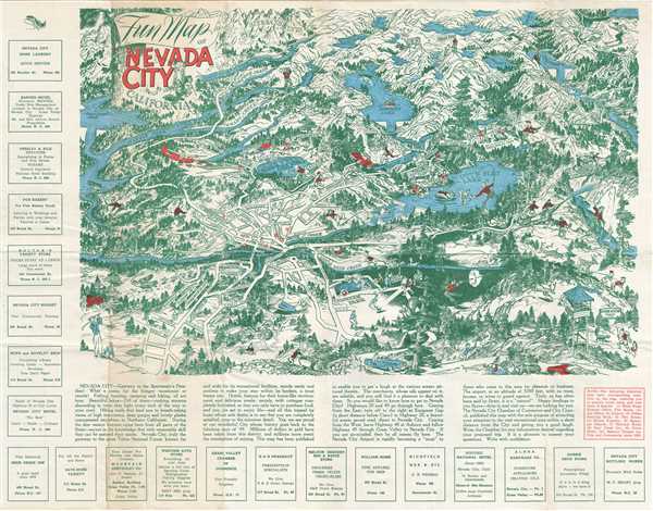
Fun Map of Nevada City California.
1940s (undated) 17 x 22 in (43.18 x 55.88 cm)
1940s (undated) 17 x 22 in (43.18 x 55.88 cm)
Description
This is a beautiful 1940s pictorial map of the city of Nevada, California. It covers this popular vacation destination, with beautifully illustrated roads, wildlife, parks, lakes, etc. It also includes illustrations of people engaged in various recreational activities, including fishing, camping, golfing, hunting, hiking, driving, swimming, etc. Famous historical sites are identified throughout, including Wells Fargo Express Office, Fire House, Airport, Indian Sunning Rock, Miners Foundry, Episcopal Church, Deer Creek Inn, Union Hotel, Masonic Temple, etc. Text below the map promotes Nevada City as a ‘Gateway to the Sportsman’s Paradise, with information about various hotels, popular attractions, directions, and other important information useful for tourists. Advertisements for local stores are including along the left and bottom margin. Overall a beautiful depiction of this popular vacation spot.
Condition
Very good. Minor wear along original fold lines. Minor spotting and toning at places.