This item has been sold, but you can get on the Waitlist to be notified if another example becomes available, or purchase a digital scan.
1834 Lucy Durfee Manuscript Schoolgirl Map of New England - Americana
NewEngland-durfee-1834$600.00

Title
1834. New England Lucy Durfee's.
1834 (dated) 20 x 15 in (50.8 x 38.1 cm) 1 : 1410000
1834 (dated) 20 x 15 in (50.8 x 38.1 cm) 1 : 1410000
Description
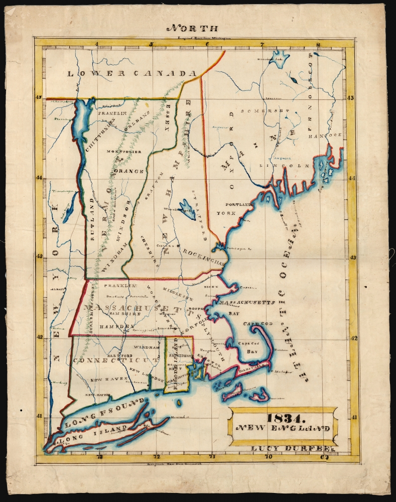
This is a beautifully executed schoolgirl map of New England, drawn in 1834 by Lucy Durfee (conjecturally the daughter of legislator and congressman Job Durfee).
A Closer Look
The map illustrates New England and parts of New York (notably Long Island), including Connecticut, Rhode Island, Massachusetts, Vermont, New Hampshire, and Maine. In the north is part of 'Lower Canada'. The states are shown along with their capitals and some principal cities. Like most schoolgirl maps, this is executed on paper with pen, ink, and watercolors. Mountains are indicated pictorially, with an elegance modeling the engraved maps of the period. Rivers are carefully drafted and named as well, showing that the mapmaker had good references which she was following scrupulously. The map is neatly lettered (more so in the larger lettering than in the finer print, admittedly). The lettering for large regions is particularly decorative, in the style of printed maps of the period. The present example was treasured from an early date, as indicated by having been mounted on linen for preservation.The Source
Schoolgirl maps, necessarily, were drawn based on the maps of their respective regions found in popular atlases of their day. Not all the student atlases available during Durfee's childhood included general maps of New England. In terms of the placenames provided, the delineations of rivers, and the scope of the map, the 1829 map Eastern States appearing in Jesse Olney's A New and Improved School Atlas is the best candidate; also, Olney had an abiding relationship with the schools in Connecticut, and the work would have been readily available in neighboring Rhode Island.Identifying the Author
We acquired this along with three other maps (the United States, Rhode Island, and Europe) which are similarly dated, and of which two are signed by the author, Lucy Durfee. We see evidence of a girl of that name born in Tiverton, Rhode Island, in about 1821 who fits contextually, but since such 'schoolgirl maps' were student works of young women virtually all destined for marriage and motherhood, it is nearly impossible to be completely certain of the identity of its young author. We do find a Lucy Durfee (1821 - 1890), who represents a compelling possibility. She was the eldest daughter of a Rhode Island lawyer, lawmaker, and congressman with a literary bent. His household would certainly have had the resources clearly available to the author of this map, and such an individual can be expected to have educated his daughter as a Federalist citizen and mother of the next generation of engaged and patriotic Americans.Schoolgirl Maps
While the use of mapmaking in teaching is first seen in Europe, mainly England, the Schoolgirl Map became a peculiarly American pedagogical tool in the first part of the 19th century, a period in which standards and purposes in women's education were changing. While boys were frequently taught the practical execution of surveys and charts, the production of attractive and informative maps appears to have been primarily the domain of young women. Such maps can be found of the World, the United States, or more specific maps of states. These were based on generally available reference maps, such as those found in the atlases produced by Carey and Lea, Finley, and Mitchell.Goals
The goals of these exercises were more far-reaching than teaching geography. Girls learned penmanship, each map often using three or more lettering styles. Mapmaking sharpened the retention and recall of factual information. Students were encouraged to take pains in their draftsmanship, and often achieved beautiful flourishes of artistic expression in their maps. But most peculiar to the American iterations of educational mapping was the goal of instilling a sense of civic pride and responsibility. Indeed, the key desired result of the education of girls in the post-Revolutionary-War United States was to prepare for the education of the next generation of American citizens, a patriotic duty which would primarily fall on the shoulders of these young women.Publication History and Other Examples
For a good overview, see Betty Mason's '19th Century Schoolgirls Were Incredibly Good at Drawing Maps.' Published July 27, 2016, by National Geographic.CartographerS
Lucy Durfee (Borden) (January 18, 1821 - July 26, 1890) was a Rhode Islander; she was born, lived, and died in Tiverton near Newport. Her father, The Hon. Job Durfee, LL.D. (1790 - 1847), was a lawyer, state legislator, a federalist congressman, a poet, and author. Lucy, the eldest of seven siblings - at least one of whom was an author as well - would have been brought up in a literate and studious household. While she appears to have published nothing, in her youth she would have been educated in the early American vein, intended to make her better able to raise a generation of literate, politically intelligent young Americans. As evidence of this, there are no fewer than four 'schoolgirl' maps in her hand that have survived. In 1846 she married Thomas Hicks Borden, with whom she raised at least eight children, to whom it is to be hoped that she passed along her studiousness and curiosity. More by this mapmaker...
Jesse Olney (1798 - 1872) was an American geographer, primarily active and successful in the production of school textbooks on that subject. His sales were second only to thos of Webster's American Spelling Book. He was educated in Whitesboro, New York, and would work as a teacher both there and in Binghamton. From 1819 to 1831 he served as principal of the Stone School in Hartford, Connecticut. In 1828 he published A Geography and Atlas, which for thirty years would be the standard geographical text used throughout the United States. It was many times enlarged and revised, and ran through 98 editions. While prior geographies opened with a description of astronomy and the solar system - a convention harkening back to Ptolemy, and the discipline of cosmography - Olney chose instead to center his pedagogy on the student's home town, expanding instead from there. The intention was to guide the student in study of the Earth by moving from that which was near and familiar to what was distant and abstract. He would later expand his repertoire of textbooks to include readers, arithmetic books, and United States history. He would enter the Connecticut legislature, using his position to influence the development of that state's schools. A Unitarian, he would be also active in advocacy for the liberal religious movements in New England. Learn More...
Condition
Very good. Manuscript pen, ink and watercolor on paper; mounted for preservation on old linen.