This item has been sold, but you can get on the Waitlist to be notified if another example becomes available, or purchase a digital scan.
1749 Grierson 'Pirate' Nautical Chart of New England, New York, Maritime Provinces
NewEngland-grierson-1749$787.50

Title
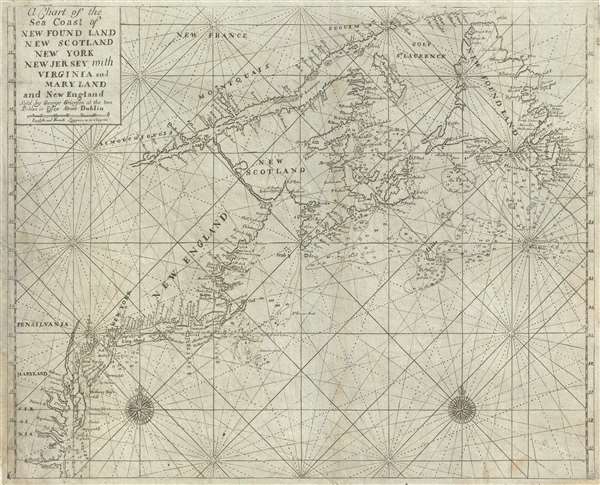
A Chart of the Sea Coast of New Found Land, New Scotland, New York, New Jersey, with Virginia and Maryland and New England.
1749 (undated) 17.5 x 22.5 in (44.45 x 57.15 cm) 1 : 5618700
1749 (undated) 17.5 x 22.5 in (44.45 x 57.15 cm) 1 : 5618700
Description
This is George Grierson's 1749 Dublin piracy of the English Pilot nautical chart or maritime map covering the eastern coast of North America from Cape Henry to the Mouth of the St. Lawrence. Grierson's piracies were issued contemporaneously with their sources in London and are today highly sought after. The map includes the coasts of Virginia, Maryland, New Jersey, New York, Delaware, Massachusetts, Maine, Nova Scotia, and Newfoundland as well as illustrating the Chesapeake Bay and Delaware Bay in full. Shading indicates the various offshore shoals including the Nantucket Shoals, St. Georges Bank, the Shoals of Acadia, the Sable Island Shoals, and others. Depth soundings appear throughout, particularly on shoals and important harbors such as the Chesapeake Bay, New York, and Martha's Vineyard. Various rivers, cities, and towns are noted along the coast including Philadelphia, New York, Boston, among others.
This map is pirated from an earlier map originally published in John Thornton in 1698 and updated by Mount and Page in 1749. The map was issued in various editions of the English Pilot. Ever eager to pirate the most up to date English cartography, Grierson issued his version of this map in the same year as the Mount and Page update, 1749. He also issued a second edition in 1767. Grierson's piracies fully new engravings and were significant in developing Dublin's reputation as a map publishing and engraving center. Today, they are far rarer than the Mount and Page maps from which they are derived and have developed their own cadre of active collectors.
This map is pirated from an earlier map originally published in John Thornton in 1698 and updated by Mount and Page in 1749. The map was issued in various editions of the English Pilot. Ever eager to pirate the most up to date English cartography, Grierson issued his version of this map in the same year as the Mount and Page update, 1749. He also issued a second edition in 1767. Grierson's piracies fully new engravings and were significant in developing Dublin's reputation as a map publishing and engraving center. Today, they are far rarer than the Mount and Page maps from which they are derived and have developed their own cadre of active collectors.
Cartographer
George Grierson (1680 - October 27, 1753) was an Irish printer and publisher active in Dublin during the first part of the 18th century. Grierson began publishing when he married Jane Blow, a daughter of the prominent Irish paper making and publishing family of James Blow. In 1727, he was admitted as a Freeman to the city of Dublin and was appointed to the office of Printer General to His Majesty in Ireland. Operating under the title, 'Kings Printer in Dublin' from 1732 to 1753, Grierson was the only printer in Dublin allowed to print Holy Bibles. Later Grierson's attention turned toward cartography, which he identified as a profitable sideline to Bible work. Most of Grierson's cartographic work involved pirating the work of the prominent English eccentric and map publisher Herman Moll. Grierson's first 'Moll' piracies were published shortly following Moll's death in 1732. Though superficially identical to the maps in Moll's The World Describ'd, Grierson's maps are in fact complete re-engravings, often with new cartouche work bearing unique ‘Irishcentric' dedications and themes. Grierson also issued piracies of The English Pilot and Salmon's Modern History. Although George Grierson can be credited with few original maps, his work established Dublin as a center for cartographic engraving and publication in the 18th century. Today's Grierson's Irish versions of Moll's maps are far rarer than Moll's own work and are highly sought after by collectors. Following his 1753 death George Grierson's son, Boulter Grierson, took over the business, beginning a family printing dynasty that would last well into the 19th century. Grierson's offices were located at the 'Sign of the Two Bibles and King's Arms', Essex Street, Dublin. More by this mapmaker...
Source
Grierson, G., The English Pilot, the Fourth Book, (Dublin: Grierson) 1749.
The English Pilot, published from 1671 to 1794, was the brain child of John Seller (1630 – 1697). Seller, recognizing a lack of quality English-made nautical charts, began to compile and engrave charts for a new maritime atlas as early as 1669. That same year he announced the publication of the English Pilot. The work was intended to be published in geographically specific volumes such that only the necessary maps need accompany a voyage. The English Pilot, The First Book, covering English waters, was published in 1671. Despite his claims, most of the maps in the first book were not English productions, but rather worn out Dutch map plates purchased as scrap and then retooled with Seller's imprint. Nonetheless, the work proved popular among merchant seamen and earned him the title 'Hydrographer in Ordinary' as well as copyright protection for 30 years. Seller failed to fully realize his grand scheme but it was picked up in earnest by other cartographers, including William Fisher, John Thornton, John Wingfield, Richard Mount and Thomas Page. Subsequent volumes followed including The Second Book, covering the Mediterranean; The Third Book covering African and Arabian coasts; The Fourth Book comprising the first British atlas exclusively dedicated to the Americas; The Fifth Book, a volume of practical Navigation; and The Sixth Book focusing on East Asian waters. The English Pilot was issued in over 40 editions with a print run exceeding 100 years. It was also pirated by George Grierson and published in Dublin under his imprint. It is one of the most important British atlases ever published.
Condition
Very good. Light toning. Minor verso repair, left side, form margin, 1 inch. Margin repair, lower right corner.
References
Brown University, John Carter Brown Library, Cabinet Ca767 /1. Phillips, Atlases 1162, no. [15]. Boston Public Library, Leventhal Center, 05_04_000167.