This item has been sold, but you can get on the Waitlist to be notified if another example becomes available, or purchase a digital scan.
1928 Griswold Tyng Pictorial Map of New England
NewEngland-tyng-1928$150.00

Title
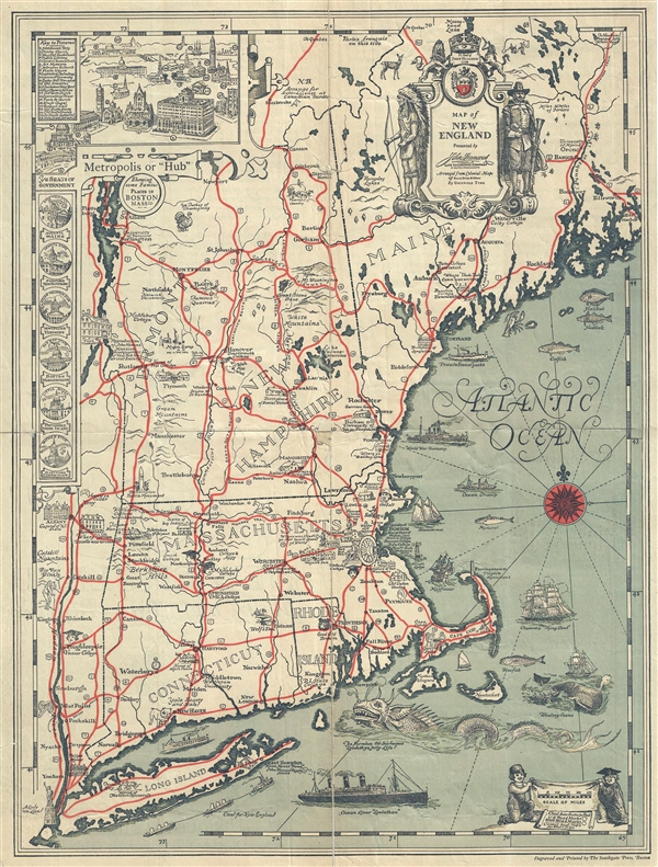
Map of New England.
1928 (undated) 21 x 15.5 in (53.34 x 39.37 cm) 1 : 1267200
1928 (undated) 21 x 15.5 in (53.34 x 39.37 cm) 1 : 1267200
Description
An uncommon 1928 pictorial map of New England drawn by the illustrator Griswold Tyng on behalf of the John Hancock Mutual Life Insurance Company of Boston. The map covers all of New England from Long Island to northern Maine and from Lake Champlain to Mount Desert Island. Features numerous vignettes illustrating ships, sea serpents, fish, lighthouses, and other regionally specific scenes. Historical sites are illustrated with vignette drawings of significant buildings, such as Longfellow's Birthplace, the Statue of Liberty, and the Old Man in the Mountain, among many others. Colleges are represented by their mascots in the case of Yale and Brown. Women's Colleges, such as Vassar, Mount Holyoak, and Wellesley, show pictures of young women in graduation caps. An inset to the left of the map illustrates important buldings depicted on the map as well as state capitals.
Rumsey notes that the map is 'arranged from colonial maps of Blaeu, Speed, and others.' We see little evidence of this other than the fact that the artist took some stylistic inspiration from these charts. For example, the cartouches in the upper right and lower left, which while bearing different figures and designs, are clearly inspired by the cartouches appearing on Blaeu's 1635 Nova Belgica et Anglia Nova.
This map was engraved and printed by Southgate Press of Boston.
Rumsey suggests that this map is 'arranged from colonial maps of Blaeu, Speed, and others.' We see little evidence of this other than the fact that the artist took some stylistic inspiration from these charts. For example, the cartouches in the upper right and lower left, which while bearing different figures and designs, are clearly inspired by the cartouches appearing on Blaeu's 1635 Nova Belgica et Anglia Nova.
This map was engraved and printed by Southgate Press of Boston.
Cartographer
Griswold Tyng (August 13, 1883 - March 6, 1962) was an American painter and illustrator active in Massachusetts. Tyng was born in Dorchester, Massachusetts to Elizabeth (Walworth) and Stephen H. Tyng. He studied art under Joseph De Camp and Howard Pyle at the Massachusetts Normal Art School (now the Massachusetts College of Art and Design). Tyng worked for many years as an illustrator for the Boston Planning Board. He also produced several pictorial maps and illustrated many books, especially children's books, while also pursuing more 'serious' artistic work, especially landscape paintings. Cartographically he is responsible for at least three maps, a 1928 pictorial map of New England, a 1929 pictorial map of the East Coast of the United States, and a c. 1930 pictorial map of Boston Common. Tyng married Clara Margaret Fuller, known as Margaret, on June 10, 1912, with whom he had two children. Tyng was killed outside his home after being hit by a car while crossing the street after mailing a letter. More by this mapmaker...
Condition
Good. Professionally repaired and backed on archival tissue. Chip loss at center, repaired. Fold splits, repaired.
References
Rumsey 8211.003. OCLC 54351361.