This item has been sold, but you can get on the Waitlist to be notified if another example becomes available, or purchase a digital scan.
1852 Williams and Redding Map of New England: Telegraph and Railroad
NewEngland-williams-1852$875.00

Title
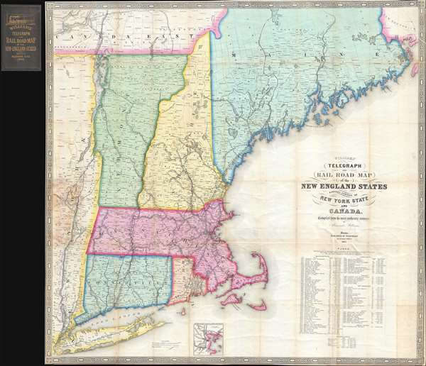
Williams' Telegraph and Rail Road Map of the New England States Eastern Portion of New York State and Canada.
1852 (dated) 32 x 30.5 in (81.28 x 77.47 cm) 1 : 775000
1852 (dated) 32 x 30.5 in (81.28 x 77.47 cm) 1 : 775000
Description
An extremely rare large format 1852 map of New England published by Alexander Williams and George C. Redding. This was the best railroad map of New England issued following the explosion of railroad construction in the late 1840s. It was prepared to facilitate the first wide scale timely newspaper distribution network in New England. The map covers from the Hudson Valley in Eastern New York to the Maine / New Brunswick border, including all of Massachusetts, Connecticut, Rhode Island, Vermont and New Hampshire, as well as parts of Maine. It provides a detailed breakdown of the rail network as of 1852, including identification of railroad companies, distances, and notes on the construction of the many lines. An inset at bottom center details the Grand Junction Railroad.
We can only imagine Williams' frustration in trying to organize and maintain this delivery network without a comprehensive map illustrating all of the railroad lines throughout New England in detail. Thus, with his characteristic industry, Williams set out to create one, producing the presently offered map in 1852, the same year that J. H. Colton issued his own important railroad map of the same region. Even so, Williams' map is far superior to the Colton map. Williams sacrifices topographical detail to focus on clarity in describing railroad network, with graduated makings along the lines, distances, clear notation of stops, and identification of each railroad company. With this map in hand, it is easy to understand how Williams and Redding managed the reliable and fast distribution of newspapers throughout New England.
New England Railroad Network
The rail network in New England began being constructed in the early 1830s, with lines like the Boston-Providence Line and Boston-Lowell Line being the first. Despite these outliers, by far the bulk of the railroad network was constructed between 1841 and 1852, with the majority being constructed after 1847, particularly outside of Massachusetts and Rhode Island. The first compressive railroad map of New England was David Burr's 1839 postal map. Burr included on his 1839 map lines he anticipated being completed by 1840, but even so, at its issue, there were then less than 20 lines active in New England, the majority of which were in Massachusetts. New Hampshire and Rhode Island had only a single active line, Maine and Connecticut had two, and Vermont had none. By 1852, there were more than 100 active lines running throughout New England by various competing companies, many of which used different track gauges and actively worked to confound their competitors. The New England rail network was not comprehensively consolidated onto a single map until 1852, when two maps were issued, the present map by Williams, and a more common map by J. H. Colton.First Newspaper Distribution Network
When this map was issued, Williams was a partner at the George C. Redding bookselling and publishing firm, Redding and Co. The Redding firm was best known at the time as Boston agents for various periodicals and newspapers from around the United States and Europe. Leveraging the potential of the fast expanding railroad network, Williams established the first expansive distribution system for rapidly sending current newspapers and periodicals throughout New England. This was a remarkable and novel achievement for the time, as described by the Boston Globe,…in the following year [1841] Williams became a silent partner in the business with Mr. Redding. Here Mr. Williams found exceptional opportunity for the display of his organizing ability. Up to this time there was no such thing as dispatch in sending magazines and papers to other parts of New England, and he organized a system for his own special purpose. It was by his enterprise that people in the towns of Maine, New Hampshire and Western Massachusetts, and even as far as Canada, were able to receive weekly papers and magazines the day after their publication.Most Accurate and Sophisticated Early New England Railroad Map
We can only imagine Williams' frustration in trying to organize and maintain this delivery network without a comprehensive map illustrating all of the railroad lines throughout New England in detail. Thus, with his characteristic industry, Williams set out to create one, producing the presently offered map in 1852, the same year that J. H. Colton issued his own important railroad map of the same region. Even so, Williams' map is far superior to the Colton map. Williams sacrifices topographical detail to focus on clarity in describing railroad network, with graduated makings along the lines, distances, clear notation of stops, and identification of each railroad company. With this map in hand, it is easy to understand how Williams and Redding managed the reliable and fast distribution of newspapers throughout New England.
Census on Rarity and Editions
Despite the obvious utility of Williams' map, its rarity suggests that it was meant mostly for internal use in the Williams-Redding distribution network or simply not issued in great quantities. The present offering is the rare first edition, but later editions were issued in 1854 and 1855. The Library of Congress owns both of these, but not the first edition. The New York Public Library owns an 1854 edition. Two inferior uncolored examples of the first edition appear at the Boston Public Library.CartographerS
Alexander Williams (August 24, 1818 – January 11, 1900) was a Boston based bookseller and publisher active in the middle to late 19th century. Williams was born near Fort Hill, Roxbury, Boston in 1818, the son of an Episcopalian bookseller, and grandson of Captain Robert Williams. As a young man he was indoctrinated into the book trade by his father and uncle, then the largest booksellers in Boston, who operated under R. P. and C. Williams on Cornhill Square at 209 Washington Street. It is said that the Cornhill bookstore was a popular hangout for luminaries of the period, including Emmerson, Longfellow, Willis, Sargent, Holmes, and others. In 1832 Williams moved to New York in order to expand his knowledge of the book trade under Elam Bliss, a New York bookseller and publisher. In New York, Williams befriended Aaron Burr, J. Fennimore Cooper, Fitz Green Halleck, and Washington Irving, among others. Williams returned to Boston in 1840 to take a position with George W. Redding in the publishing and magazine distribution department of Redding and Company. By 1841, he had become a silent partner in the Redding firm setting up a magazine delivery service throughout New England. By 1855 the newspaper and magazine delivery service became so prosperous that the partners determined to split it off as the New England News Company, with Williams as the head and primary shareholder. Shortly thereafter, Williams left the New England News Company to work again with his father and uncle on Washington Street. In 1869, one of the most iconic bookstores in Boston, the Old Corner Book Shop (27-29 Bromfield Street) became vacant. Williams took it over, operating it until his retirement in 1869. In 1883, he dissolved the old Cornhill Shop, which was at the time a partnership consisting of Williams, C. L. Damrell, H. M Upham, and J. G. Cuppers. Williams lived at 139 Newbury Street, Boston. He died in 1900 of complications relating to pneumonia and advanced age. He was survived by two sons, Alexander Williams J. and Charles C. Williams, and one daughter. More by this mapmaker...
George W. Redding (fl. c. 1840 – c. 1859) was the founder of Redding and Company, Boston based publishers, book and magazine agents, and quack pharmaceutical agents active in the middle part of the 19th century. Redding's personal and business histories are vague. The firm appears to have been founded around 1841 by George W. Redding and Alexander Williams (August 24, 1818 – January 11, 1900). From their offices at 8 State Street, the firm published their own works, acted as an agent for books and magazines from London and New York, and sold salves and ointments. Advertising for the Redding firm's publications begins appearing around 1841. Under the guidance of Williams, a supreme organizer, the firm introduced magazine distribution throughout New England – at the time a novelty through which they enjoyed significant success. The publishing arm of Redding and Company appears to have dissolved around 1855, but the pharmaceutical arm continued until about 1859. The cure-all Russia Salve was among their more successful products. After 1860 there are conflicting reports. Some suggest that Redding himself died sometime before 1873 and the business passed to other owners. Other sources, including the Boston Directory, suggest that the firm continued to operate as late as the 1880s. Learn More...
Condition
Very good. Slight wear on original fold lines. Accompanied by original binder. Backed on archival tissue.
References
OCLC 50514104. Boston Public Library, G3721.P1 1852 .W5. New York Public Library Map Div. 15-5267 (1854). Library of Congress, Railroad Maps, 109. Library of Congress, G3721.P3 1854 .W5.