This item has been sold, but you can get on the Waitlist to be notified if another example becomes available, or purchase a digital scan.
1832 S.D.U.K. Map of New England, New York and New Jersey
NewEnglandNY-sduk-1832-2$75.00

Title
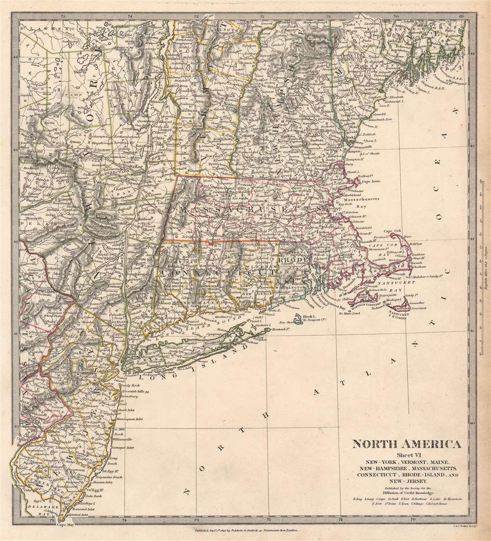
North America. Sheet VI. New-York, Vermont, Maine, New-Hampshire, Massachusetts, Connecticut, Rhode-Island, and New Jersey.
1832 (dated) 14.25 x 13 in (36.195 x 33.02 cm) 1 : 1770000
1832 (dated) 14.25 x 13 in (36.195 x 33.02 cm) 1 : 1770000
Description
This is an 1832 Society for the Diffusion of Useful Knowledge (S.D.U.K.) map of New England, New York, and New Jersey. Created with impressive attention to detail, important towns, lakes, mountains, and other topographical features are noted throughout, with elevation rendered by hachure. The road network is illustrated in detail as well, along with canals, including the Morris Canal in New Jersey, the Farmington Canal (labeled Parmington here) in Connecticut, and the Hampden Canal in Massachusetts. An unlabeled railroad traverses Massachusetts from Boston west to New York and continues into New York toward Albany.
Publication History and Census
This map was engraved by J. and C. Walker and published in 1832 by Baldwin and Cradock for the Society for the Diffusion of Useful Knowledge. We note a single cataloged example in OCLC, at Princeton University. An example is also part of the David Rumsey Map Collection. The complete set of S.D.U.K. maps of North America, however, are well represented in institutional collections. Although the Society formally closed its doors in 1848, subsequent reissues of the S.D.U.K. atlas were printed well into the 1870s by Chapman and Hall, who acquired the original plates.CartographerS
The "Society for the Diffusion of Useful Knowledge" (1826 - 1848) was a Whiggish organization founded in 1828 at the instigation of idealistic British lord Henry Peter Brougham. The admirable goal of the Society was to distribute useful information via a series of publications to the English working and middle classes. It promoted self-education and the egalitarian sharing of all knowledge. While closely tied to the London University and publishing houses on the order of Baldwin and Cradock, Chapman and Hall, and Charles Knight, the Society failed to achieve its many lofty goals in finally closed its doors in 1848. Most likely the failure of the Society resulted from its publications being too expensive for its intended lower to middle class markets and yet not large and fine enough to appeal to the aristocratic market. Nonetheless, it did manage to publish several extraordinary atlases of impressive detail and sophistication. Their most prominent atlas consisted of some 200 separately issued maps initially published by Baldwin and Cradock and sold by subscription from 1829 to 1844. Afterwards, the Society combined the maps into a single world atlas published under the Chapman and Hall imprint. In its day, this atlas was unprecedented in its quality, scope, and cost effectiveness. Today Society, or S.D.U.K. as it is commonly known, maps are among the most impressive examples of mid-19th century English mass market cartographic publishing available. The S.D.U.K. is especially known for its beautiful and accurately detailed city plans. More by this mapmaker...
Baldwin and Cradock (fl. c. 1810 - 1860) were London based publishers working in the early to mid 19th century. They are best known for their publication of the Society for the Diffusion of Useful Knowledge's ground breaking subscription atlas. They also published John Thomson's magnificent New General Atlas from 1814 - c. 1820. In addition to their cartographic corpus, the firm had wide ranging publishing interests in many other areas, including books, broadsides, and an investment in Blackwoods Magazine. They had their offices at 47 Paternoster Row, London, England. This firm also published under the imprint Baldwin, Cradock, and Joy and Cradock and Joy. Learn More...
John Walker (1787 - April 19, 1873) was a British map seller, engraver, lithographer, hydrographer, geographer, draughtsman, and publisher active in London during the 19th century. Walker published both nautical charts and geographical maps. His nautical work is particularly distinguished as he was an official hydrographer for the British East India Company, a position, incidentally, also held by his father of the same name. Walker's maps, mostly published after 1827, were primarily produced with his brothers Charles Walker and Alexander Walker under the imprint J. and C. Walker. Among their joint projects are more than 200 maps for the influential Society for the Diffusion of Useful Knowledge Atlas (SDUK). In addition they published numerous charts for James Horsburgh and the British Admiralty Hydrographic Office, including Belcher's important map of Hong Kong and Carless' exploratory map of Karachi. The J. and C. Walker firm continued to publish after both Walkers died in the 1870s. Learn More...
Source
Maps of the Society for the Diffusion of Useful Knowledge, (London: Baldwin and Cradock) 1832.
Condition
Very good.
References
Rumsey 0890.133. Phillips (Atlases) 794. OCLC 1250645841.